October 14, 2010
Ried Glacier Rapid Glacier loss, Switzerland
Posted by Mauri Pelto
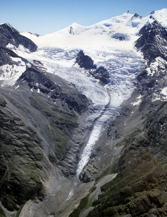
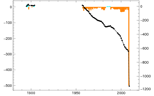
Ried Glacier is beneath the Durrenhorn in the Pennine Alps of Switzerland. The glacier was 6.3 km long in 1973. In 2010 the glacier is 5.1 km long. From the Swiss Glacier Monitoring Network annual measurements, Ried Glacier retreated 300 m from 1955-1990, 8 meters/year. From 1990-2008 retreated an additional 300 m, 30 m/year. Than in 2009 the glacier retreated 500 m. A comparison of a 2004 image taken by M. Funk and a Sept. 2008 image from D. Gara
 indicate why the change was so abrupt. The glacier had been retreating upvalley with a long gentle terminus tongue. This section of the glacier separated from the glacier in late 2008, with the terminus now ending on a steep rock slope. There is still stagnant ice in the valley below the end of the current glacier. It is heavily debris covered and no longer connected to the glacier system. This glaciers recent rapid retreat parallels that of Dosde Glacier, Italy and Triftgletshcer, Switzerland and Rotmoosferner, Austria. A look at the glacier system and the terminus in Google Earth imagery provides a broader view of the glacier behavior. The terminus in this image still extends downvalley with the low sloping tongue that is now separated. Current terminus marked with red-T.

In the imagery above the glacier is still connected to the terminus tongue. It is evident that the glacier has two primary icefalls at that time. The upper icefall is the location of the annual snowline, where accumulation tends to persist throughout the year. Below this point only seasonal snowfall is retained. The retreat history from the Swiss Glacier Monitoring Network is seen below.


 Dean of Academic Affairs at Nichols College and Professor of Environmental Science at Nichols College in Massachusetts since 1989. Glaciologist directing the North Cascade Glacier Climate Project since 1984. This project monitors the mass balance and behavior of more glaciers than any other in North America.