
November 12, 2009
Pine Island Glacier Grounding Line Updated 2012
Posted by Mauri Pelto
The Pine Island Glacier is a principal outlet glacier of the West Antarctic Ice Sheet draining into the Amundsen Sea. The ice stream is 40 km wide as it reaches the sea. Recent retreat, thinning and acceleration have focussed attention on this glacier. This is a brief note in support of a RealClimate article. The grounding line is of principal concern here. This is where the glacier goes afloat. The grounding line is where the bottom of the glacier comes in contact with the ground, in this case the sea bottom. The grounding line is an anchoring point for the outlet glaciers. The length of the glacier that is grounded is being both slowed and stabilized by the basal friction. Beyond the grounding line toward the margin the floating ice shelf is susceptible to a rapid calving retreat and as the grounding line retreats, so would the calving front. Note in the image below that the current grounding line is on relatively high terrain, but is close to a deep basin. The annotated image below is from a British Antarctic Survey image, taken from their autosub program exploring beneath the ice shelf of the Pine Island Glacier combined with data from radar altimeter data flown by NASA. The second image below is a profile of depth under Pine Island Glacier from (Shepard et al, 2001)that indicates that beyond the grounding line the depth remains more than 1000 meters below sea level for approximately 200 km. 
 Grounding line retreat could lead to the glacier retreating into this basin, not a stable situation. Basal melting is of particular concern, has been calculated to exceed 15 m/year. In addition the formation of basal crevasses which are much wider than surface crevasses may be critical in the rifting process. The British Antarctic Survey, NASA and several universities in particular have been focusing on this glacier. The second image shows the grounding line in the surface. This is an annotated satellite image from NASA. Just above the grounding line you can note that the surface of the glacier has some large scale roughness which indicates the impact of the sub-glacier topography.
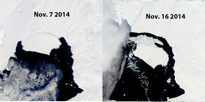
  This topography acts to slow and buttress the glacier. This area is above the topographic rise from the deep basin to the higher terrain of the current grounding line. The ongoing focus on the Pine Island Glacier will be fascinating to watch. In particular the emphasis on the oceanographic aspects beneath the ice shelf. The melt rates beneath the ice shelf are significant, on the order of 15 m/year. This is an aspect that has received less attention and will certainly yield interesting results, considerable technologic frustrations and innovations. The nearby Smith Glacier has experienced a similar inland spread of rifting and retreat. In 2011 an additional rift has formed that is 20-25 km inland of the calving front, first noted by NASA’a Operation Icebridge. November 3, 2011 MODIS imagery is seen below. The rifts in both 2001 and 2011 have begun on the east edge of the ice stream an propogated westward. The propagation is more likely as an exploitation of basal crevasses then surface crevasses. The rift from 2011 led to iceberg formation in the fall of 2013 as seen in MODIS images.
  On October 5, 2011 MODIS imagery indicates no rift. By Sept. 17, 2012 a second rift parallel to the first had developed.

 Dean of Academic Affairs at Nichols College and Professor of Environmental Science at Nichols College in Massachusetts since 1989. Glaciologist directing the North Cascade Glacier Climate Project since 1984. This project monitors the mass balance and behavior of more glaciers than any other in North America.