
18 August 2014
Camille Struck 45 Years Ago Tonight
Posted by Dan Satterfield
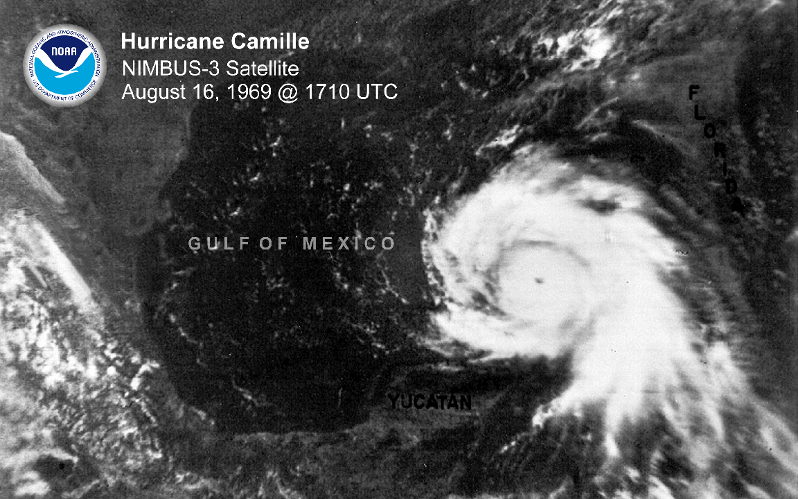
Decent quality, and real-time satellite images were very new in 1969.
The stagnant muggy heat of August began to break 45 years ago today on the coast of Mississippi, as clouds and winds increased. Later that evening the world turned upside down as a 30 foot wall of water whipped by winds of an incredible 190 mph changed the Mississippi Coast forever.Hurricane Camille was one of the most violent hurricanes ever to hit the mainland U.S., and it still ranks with names like Katrina and Sandy.
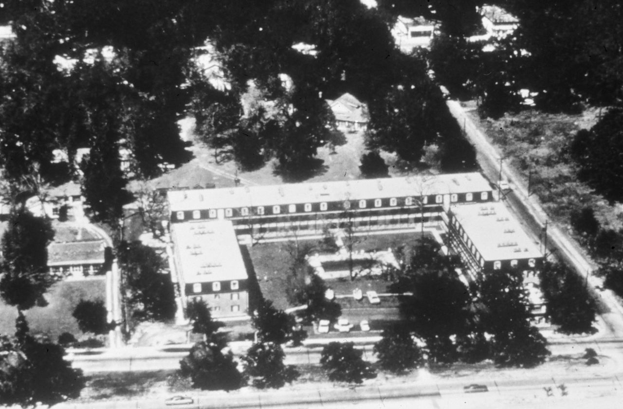
Richelieu Apartments before Camille (NOAA)
Hurricane Camille was not a large hurricane and Katrina produced a higher storm surge with less wind because it was much larger. Residents of an apartment complex in Pass Christian supposedly had a hurricane party rather than evacuate, but this commonly heard story is dubious at best. What is certain is that the apartment complex disappeared.
A shopping center was rebuilt in its place.
Hurricane Katrina wiped that structure out.
The pressure in Camille was measured at 909 millibars by a weather bureau barometer, and that barometer remained in use until it too was destroyed….by Katrina.
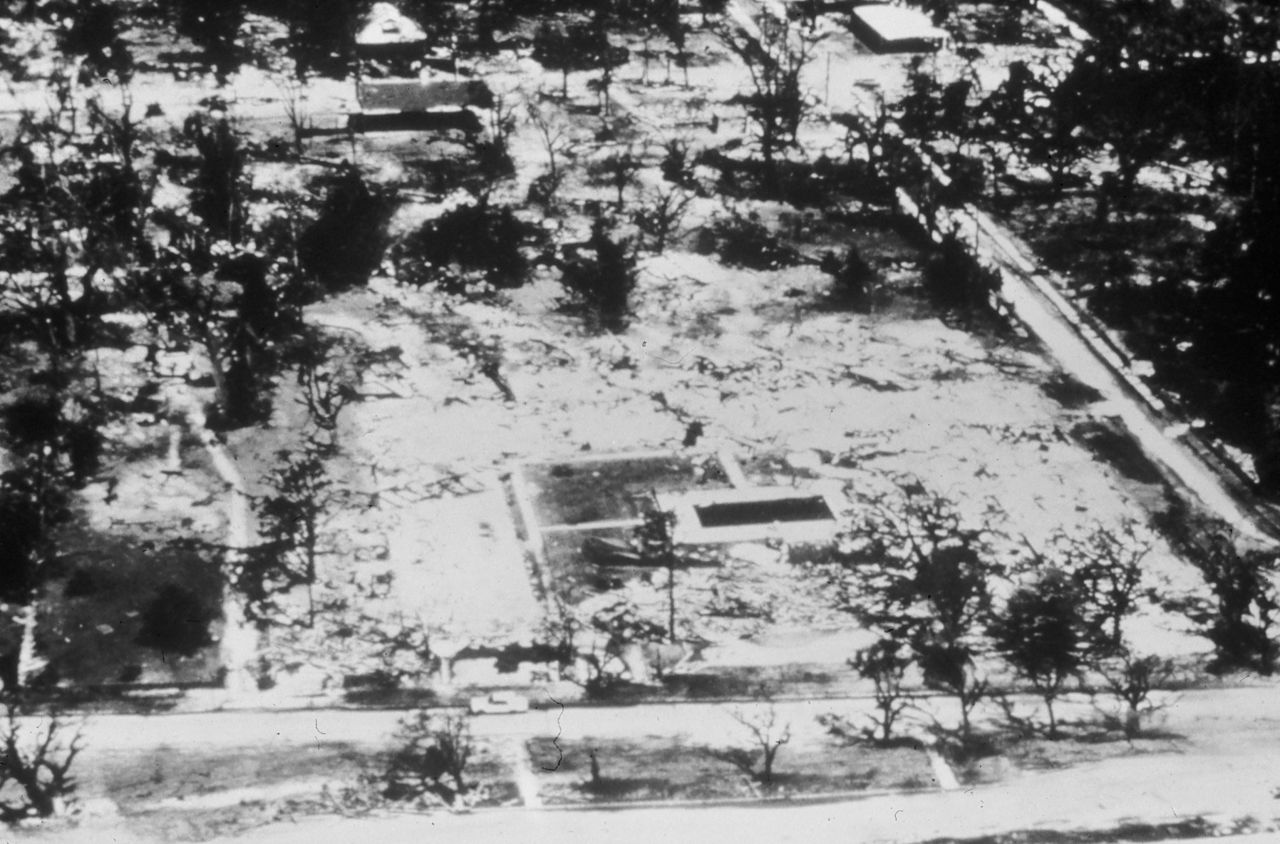
After Camille. (NOAA)
Camille was a category 5 hurricane, and only two others hit the U.S. in the 20th century: Andrew in 1992 hit Miami, and the Labor Day Hurricane in the Florida Keys in 1935. The Labor Day storm storm had 200 mph winds and inspired my favorite movie- Key Largo ( starring Humphrey Bogart, Lauren Bacall, Edward G Robinson, and a Florida hurricane. A studio can’t miss with a cast like that!)
A fascinating report written 30 years after Camille is worth reading. Some quotes:
For the entire length of the Mississippi coast extending three to four blocks inland, the destruction from Hurricane Camille was almost complete. Residences, motels, apartments, restaurants, and other buildings were swept off their foundations, demolished, and deposited in piles of scrap lumber and rubble together with fallen trees, smashed automobiles, and grounded boats (USACE 1970, p. 65) (Figure 19). Only a stairway remained from a house designed by a local architect to be “hurricane proof”. The designer’s body and those of several of his friends who had attempted to wait out the storm in his house were found 45 days later (Leyden 1985, p. 4).
At the Weather Observatory at Boothville, Louisiana, just north of Venice, five weathermen were prepared to ride out the storm and make detailed observations. The observatory was designed to withstand hurricane conditions, and the structure had been built on prestressed concrete pilings with the main floor 12 feet above ground. Emergency power was operating, and radio contact was maintained with the Hurricane Forecast Center in New Orleans. At about 6:40 p.m., a pressure of 959.7 mb was recorded. About the same time, the wind-speed equipment became inoperative after having indicated wind gusts to 107 mph. Soon after, one meteorologist noticed that the water was rising rapidly and had reached the catwalk just below the floor of the observatory. Shortly after, the water rushed into the building. The emergency generator room was flooded, and the weathermen lost all contact with the outside world. They sought refuge in the electronics shop, and the water continued to rise until it was chest-deep on some observers.
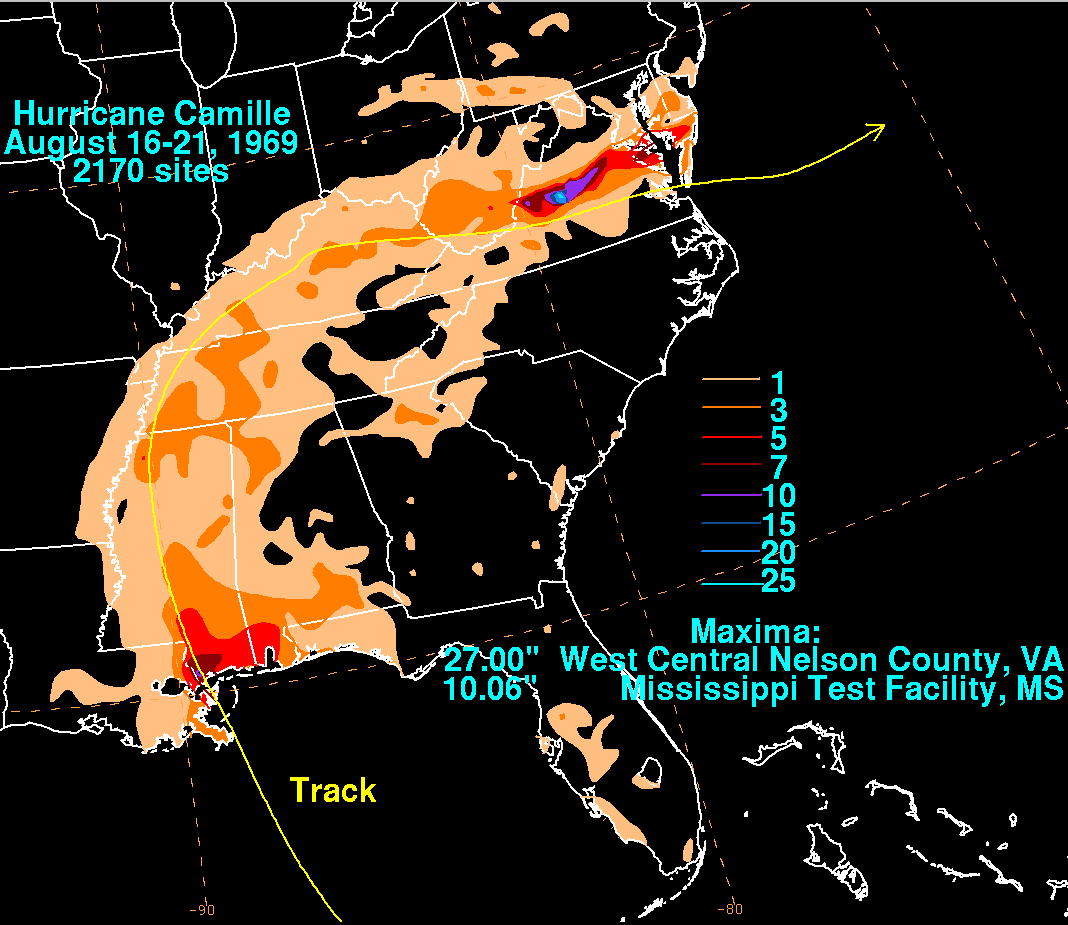
Rainfall from Camille was highest in Virginia. NOAA image from the Hydro-Meteorological Prediction Center (HPC).
What you may not know is that Camille was not just a catastrophe for the Gulf Coast, it produced extreme rainfall as it moved inland, and it’s still the worst natural disaster ever to hit Virginia. Here is what the report says:
As of September 8, 1969, the state had counted 107 dead and 102 injured. The majority of death and damages occurred in Nelson County, Virginia. Of the 313 houses destroyed, 250 were located in Nelson County. Of the 415 houses suffering major damage, 225 of these were located in this county. Of the 153 people dead or missing in Virginia, 126 were residents of Nelson County – a little more than 1 percent of the county’s population; 54 people were killed along a 4-mile stretch of Davis Creek and Huffman’s Hollow (DeAngelis 1969). Communications, including roads, were completely destroyed in many communities (Figure 11). After the flood, only one highway in Virginia was intact. Some 133 bridges were destroyed or damaged, and 25 miles of primary and 175 miles of secondary roads were obliterated, with damages totaling $19 million.
Since 1969, we seem to have learned few lessons, and Sandy and Katrina are already being slowly forgotten. Those who do NOT build (and live) in homes on the coast, still subsidize the flood insurance for those who do, so a hurricane costs all of us, even those far away from its damage. I bet a lot of folks do not know that.
 Dan Satterfield has worked as an on air meteorologist for 32 years in Oklahoma, Florida and Alabama. Forecasting weather is Dan's job, but all of Earth Science is his passion. This journal is where Dan writes about things he has too little time for on air. Dan blogs about peer-reviewed Earth science for Junior High level audiences and up.