
30 April 2014
NWS Weather Radar Upgrade Proving Wildly Successful
Posted by Dan Satterfield
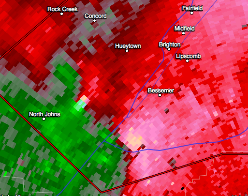
Doppler velocity data showing a supercell storm with intense rotation approaching Bessemer AL (just west of Birmingham). Was there a tornado on the ground? Read on to find out why we knew the answer was yes.
It was near midnight last night (April 28, 2014) when a strong super-cell storm developed an intense rotation as it approached Birmingham, AL (with a population of over a million people). Tornadoes are hard to spot at night (and they can often be wrapped in rain) making them invisible until it’s too late to take cover. While Doppler radar has made it possible to see this rotation inside a storm, it cannot tell us if there is a tornado on the ground. In fact, many times the answer is no, in spite of an intense low pressure center in the storm (a mesocyclone). This had lead to a high ratio of false alarms, but a new technology paid for by we the taxpayers is starting to change that.
A tornado warning was indeed issued by the NWS in Birmingham Monday night, but it was shortly thereafter upgraded to a Tornado Emergency (meaning a large dangerous tornado is on the ground and doing damage). This alert is very rare and it’s a step above a tornado warning. So, how did they know it was on the ground? Yes, there were spotter reports, but these can be unreliable anytime, and especially at night.The answer is dual polarimetric radar.
Over the last few years, NOAA has spent millions of dollars to upgrade almost all of its NEXRAD Doppler radars to this new technology (you can learn more about it here and here). By comparing the signal returned from two different types of radar waves the shape of the particles in a storm can be determined. It turns out that if a tornado is picking up houses trees and buildings, you see all kind of shapes, and there is little correlation between particles. It was thought that this would allow a signature of debris to be detected when a tornado was on the ground, but it was uncertain just how far out this might be possible to see.
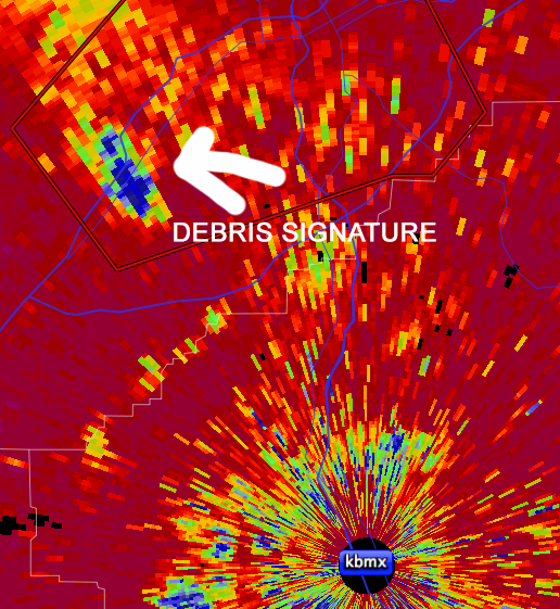
A radar signature indicating debris in the radar beam. A strong rotation was present as well.
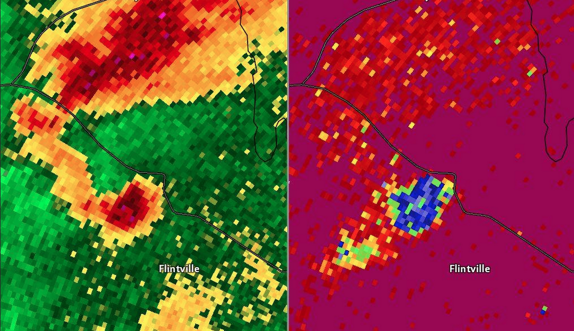
From Ari Sarsalari at WAAY TV. A hook echo is on the left with a signature indicating debris in the air on right. A tornado was present and caused heavy damage in Lincoln County,TN
The tornado outbreak of Sunday and Monday seems to indicate that in large deadly tornadoes this can be seen at quite a distance. The image above is the debris signature that showed up west of Birmingham last night and made it possible for the NWS to issue a Tornado Emergency. It confirmed reports of damage coming in from the public and this was not the only case where one was seen.
Earlier in the day, Ari Sarsalari (at WAAY-TV in Huntsville, AL) spotted this on radar just north in Lincoln County TN. So did Chris Darden (Meteorologist in Charge at the NWS in Huntsville), and the NWS office immediately issued a strongly worded tornado warning. That warning verified, as an EF-3 tornado was on the ground, which resulted in deaths and injuries. Darden said that “the dual polarimetric data has been a huge help, and has given added confidence in the warning process”.
Spencer Denton, the Chief Meteorologist at WAAY-TV agreed- “I think when we mention the word “debris” being lofted into the air, it has some impact on their decision to take cover. I went a little further and described what it could be…maybe trees, limbs, a building or structure…I think that could cause more urgency, especially for those that may not take warnings as serious as they should.”
Welcome to 21st century severe weather NOWCASTING. Dual pole radar does a lot more than this, it’s making rainfall estimations and snowfall predictions much more accurate as well. I strongly suspect that Spencer is right, and many folks who might not take a tornado warning seriously, will act differently if the person on TV tells them that there is debris in the air. Everyone likes to complain about the government spending money, but this is one case where it sure seems the taxpayers got their money’s worth.
In a big way.
 Dan Satterfield has worked as an on air meteorologist for 32 years in Oklahoma, Florida and Alabama. Forecasting weather is Dan's job, but all of Earth Science is his passion. This journal is where Dan writes about things he has too little time for on air. Dan blogs about peer-reviewed Earth science for Junior High level audiences and up.
Amen! Watched the Weather Channel and Local Arkansas stations via internet from California most of the night. The extreme precipitation is so unusual considering the amounts. In California we would expect this to be because of an atmospheric river. Do you know what the driving force was behind the impressive amounts?
yes, this system tapped a deep layer of moisture from the Gulf and the Tropical Atlantic. Flooding rains often result when a clear connection is present.
Dan,
Thanks for this explanation. I still miss your on-air explanations here in Huntsville. But I do have a question (and a comment) that I will probably also ask the folks upstairs (I am a solar scientist in the NSSTC), once they recover from this event. From what you have seen, how does the set-up for this outbreak compare with the April 27, 2011 event?
My comment: I noticed in footage of a storm shelter in the New Market area that they are not allowing pets. I seem to remember that survivors of Hurricane Katrina would not leave their pets, nor would I. Storm shelters should allow pets.
I completely agree!