
28 April 2014
Major Severe Weather Outbreak Underway In Plains/Southeast
Posted by Dan Satterfield
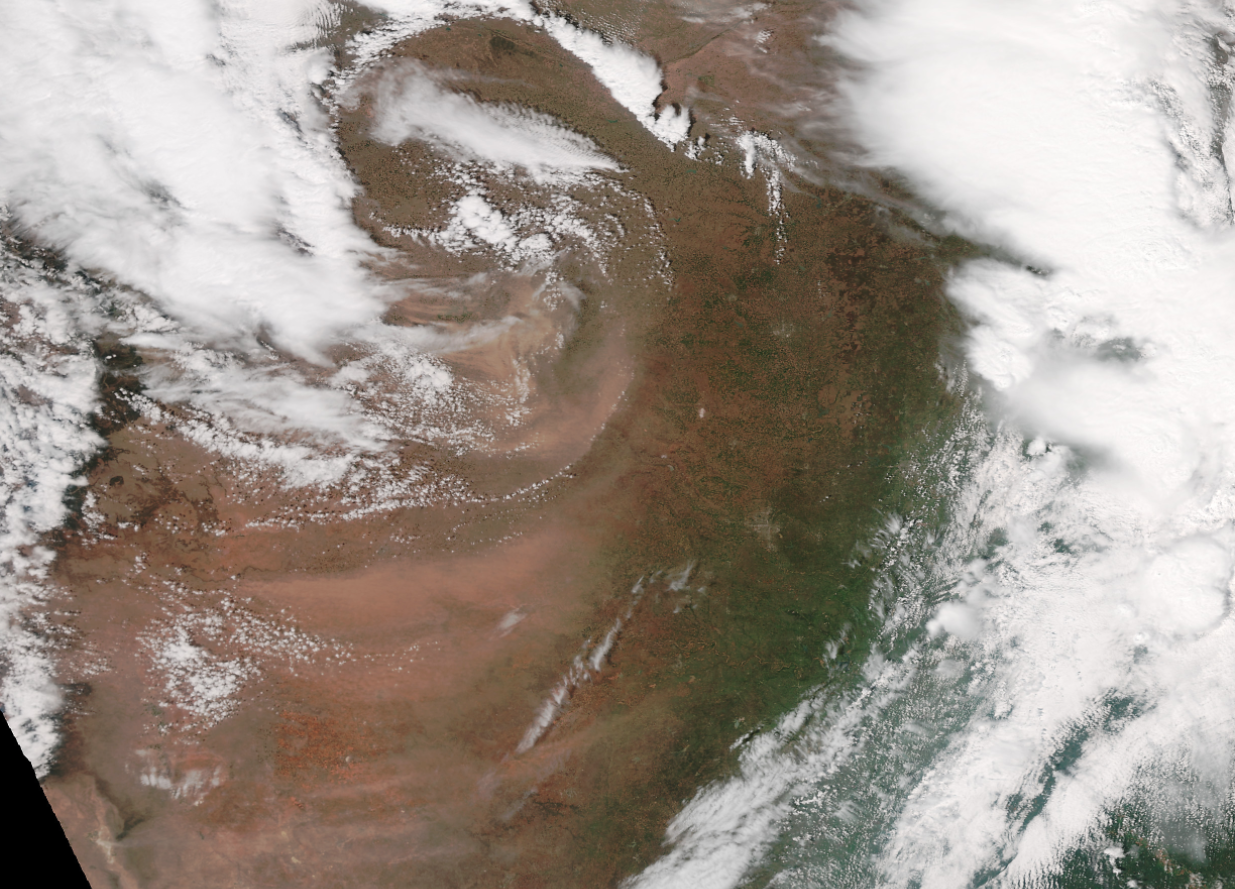
Blowing dust in OK,TX and NM,KS from the Suomi satellite this afternoon.
A strong low pressure system is really winding up in the Plains this Sunday evening, and winds are gusting to 48 mph behind dry line front through Oklahoma and Texas. Ahead of the dry line, a moist and extremely unstable airmass is in place, and storms have already developed. Keep in mind that tornadoes require both unstable air AND strong low-level wind shear, and there is plenty of both in Arkansas and Missouri.
NOAA sent up a special weather balloon sounding from Little Rock this afternoon, and it showed extreme instability and wind shear. There are several different parameters we use to measure these factors, and the special sounding was enough to put out a rare HIGH risk from the Storm Prediction center in Norman. This was followed by an equally rare PDS Tornado Watch (PDS=Particularly Dangerous Situation) for central and southern Arkansas as well.
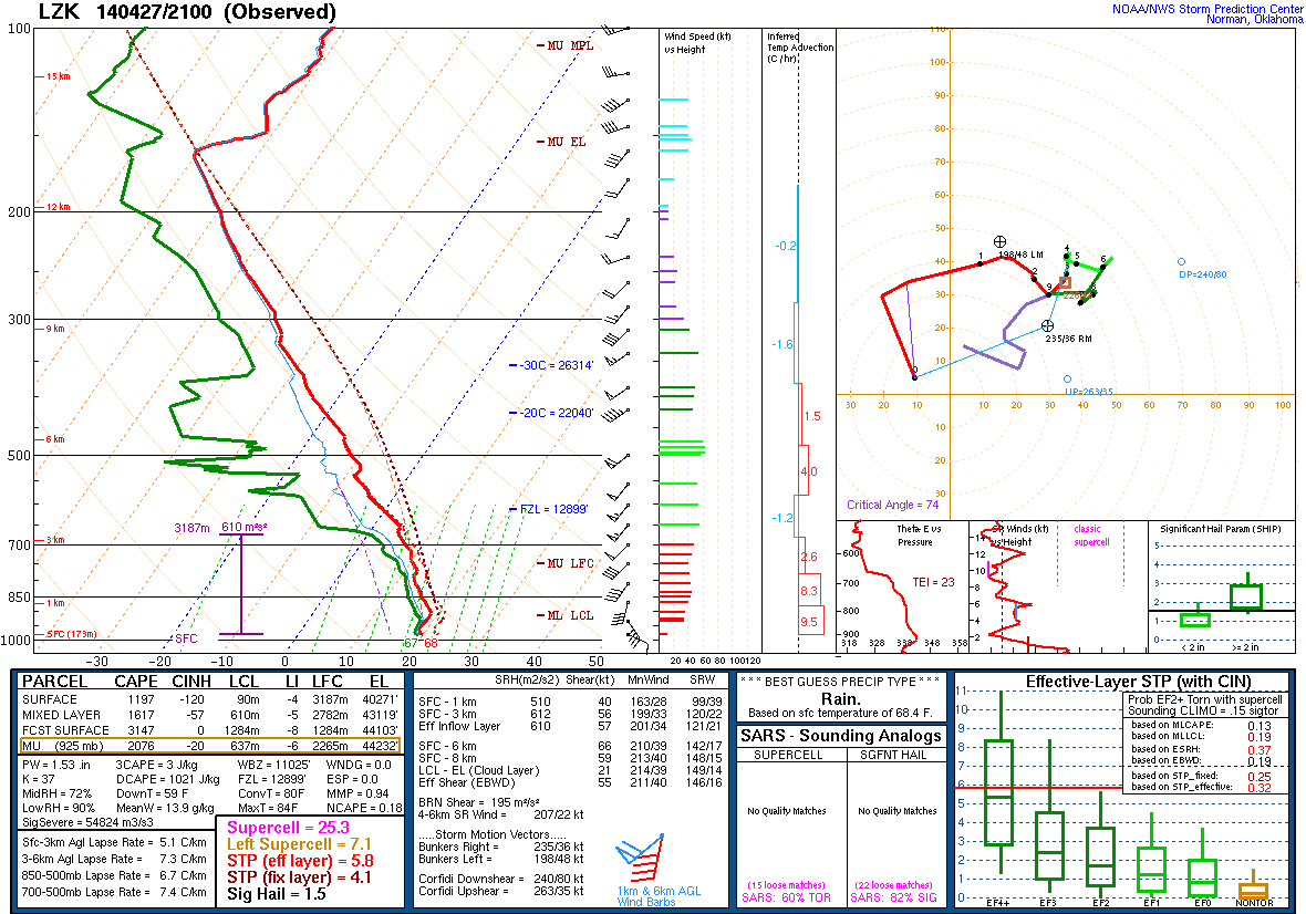
Little Rock sounding from 18 GMT Sunday showing extremely favourable conditions for large violent tornadoes.
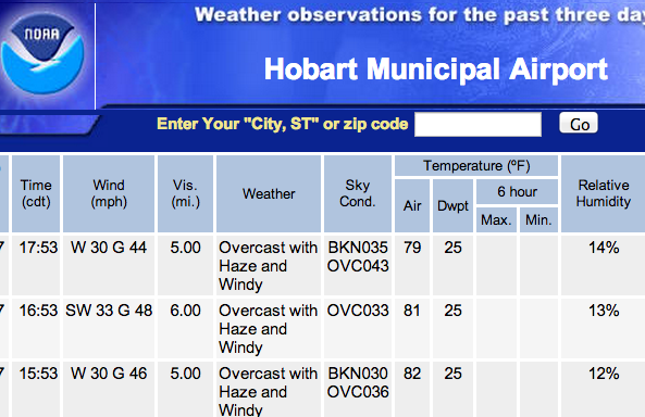
Weather observation from Hobart in western Oklahoma shows winds gusting to 48 mph with visibilities reduced to 5 miles in dust. Oklahoma City is also getting gusts to just under 50 mph.
The data from the sounding is below, and while the numbers are geek to non mets, the supercell index in the high 20’s is very rare. I’ve seen tornadic supercells with an index of 6 and lower. Higher than 15 is quite rare. The Storm Relative Helicity is a measure of the horizontal rotation in air as “seen” by a storm as it is steered along by the winds, and this too is very high and favourable for violent EF 4 and EF 5 tornadoes.
There are tornadic supercell storms in Missouri, Mississippi and Arkansas as I type this, and if you are in the watch area, remain very weather aware. Choose where you get your information from carefully; A CBM meteorologist on TV, or the NWS is your most reliable method.
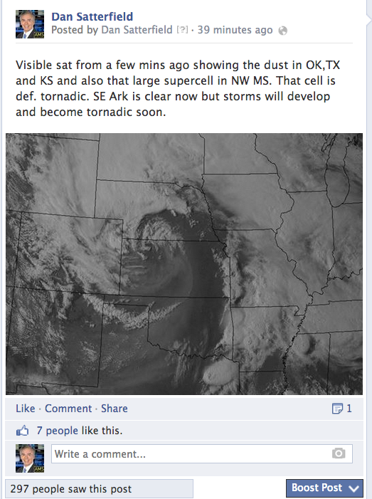
I have 32,000 likes on my FB page, but FB only showed this post to 297 people. You must bookmark the pages and check it for weather updates. Twitter is best.
By the way, some on air broadcasters with an old AMS seal were allowed to upgrade to a CBM seal even though they do not have the education requirements now in place. If you’re wondering, check out their bio. If they have a degree in meteorology, they will have almost always have that listed. “Studied meteorology at” is a code word for no degree. That said, i know some excellent broadcast mets who do not have an undergrad degree, but a CBM seal is a minimum to look for these days.
One last warning, if you follow your local met or NWS on Facebook, then BOOKMARK the page and check frequently for updates. Facebook only shows the posts to a very small number of followers who “like a page”. Look at the example from my FB page (see image). I have over 30,000 followers but less than 2000 ever see a post I make unless they go directly to my page. Twitter is a more reliable way to get weather info in critical situations. Best of all set your phone up to receive warnings and get a NOAA weather radio, and when a warning comes, turn your TV to someone you trust for the details.
Storm chasers and online Facebook pages from non-meteorologists often put out very hyped information. BEWARE of these info-wars type accounts. The Alabama EMA even posted a twitter forecast that was soon deleted comparing the impending outbreak to April 27th. A local broadcast meteorologist took exception to it and he should have. A CBM on TV will work very closely with NWS folks to get reliable info out. There is an amazing amount of cooperation between the NWS and local broadcasts meteorologists, and it’s because we all care about giving life saving info quickly and accurately.
 Dan Satterfield has worked as an on air meteorologist for 32 years in Oklahoma, Florida and Alabama. Forecasting weather is Dan's job, but all of Earth Science is his passion. This journal is where Dan writes about things he has too little time for on air. Dan blogs about peer-reviewed Earth science for Junior High level audiences and up.
Sure do miss you in Alabama.
Dan, isn’t there a “classic” shape to the temperature and dew point lines on soundings in tornado-prone areas? Does the sounding above have that shape?
Yes, It’s called a goal post sounding. It indicates low level moisture with dry air aloft and a small capping inversion to hold off convection so that the instability is released suddenly.