28 October 2012
Halloween Superstorm Heads for Mid-Atlantic
Posted by Dan Satterfield

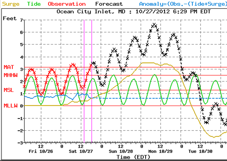
Storm surge forecast for Sandy Hook New Jersey. If this verifies we will see a billion dollar damage event. MAT means Maximum astronomical tide. MHHW= Mean higher high water. Expect flooding when the level exceeds MAT.

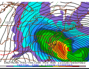
This is a forecast based on several runs of the same model with slightly different initial conditions. This is the average of all those runs. Forecasters refer to this output as short range ensemble forecasts.
The winds are already increasing along the Eastern Seaboard tonight as Sandy heads northward. I was at Cape Henlopen in Delaware before dark, and the ocean was already roaring with 5-6 foot swells. There is still some disagreement int he model guidance but I’d put the chances of landfall between Rehoboth Beach, Delaware and Sandy Hook NJ at 70%. As Sandy turns into an extratropical storm the winds will no longer be concentrated near the center and already tropical storm force winds are over 400 miles from the center.
The beaches in Delaware, and along the Eastern Shore of Maryland will see winds over 45 mph by Sunday afternoon and gusts to 60 Sunday night. As the storm approaches the Jersey coast, the winds will become northwesterly over Delaware and all of the Delmarva Peninsula. Waters will then will rise on the Chesapeake Bay side. For northern New Jersey and New York, it is a worst case scenario with the winds piling the water up around Sandy Hook and New York City. It is possible that we could see literally millions without power over several states by late Monday.
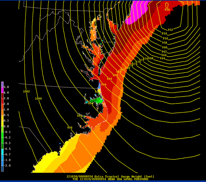
and area wide storm surge:

If the center comes ashore further south torward Lewes in Delaware or Ocean City Maryland then the highest water levels will be near and to the right of the storm center.
One important note, the NWS will be issuing storm warnings and high wind warnings for areas north of the Carolinas because Sandy will be turning into a hybrid storm and will no longer be a tropical storm. Just remember, 70 mph winds have the same force no matter what the temperature structure of the storm looks like.
Another point to consider is that since the 1938 hurricane the sea level along the coasts is 1 to 1.75 feet higher, and the atmosphere is holding about 7% more moisture because it is over a degree celsius warmer on average. The exact same storm as 1938 will be wetter and do more damage because of this. Sea level rise due to climate change will make itself known, not little by little, but in big super-storms like this. It’s also possible that the big blocking high over Greenland that is steering Sandy into the NE Coast is stronger because of the dramatic loss of sea ice this summer.
New research indicates that the sea ice loss causes the storm track to amplify, with stronger blocking highs and lows in the upper atmosphere. Did climate change cause this storm? No, probably not, but it is making it worse. No scientific doubt about that.
Something to think about… BE SAFE.


 Dan Satterfield has worked as an on air meteorologist for 32 years in Oklahoma, Florida and Alabama. Forecasting weather is Dan's job, but all of Earth Science is his passion. This journal is where Dan writes about things he has too little time for on air. Dan blogs about peer-reviewed Earth science for Junior High level audiences and up.
Really confused, and concerned, why does Accuweather site show gusts of 70-87 mph for Mon/Tue for the Arlington/DC area?
What model are they using to predict this data? Why are these wind predictions not posted on any other weather service (e.g. Intellicast, WJLA weather, Weather.com, etc.)?
Thank you.
I cannot answer for why the accuweather site has that. I do not think much of their forecasts to be honest. It will not be nearly that bad in DC. The surge forecasts are done with a special model designed for just that and it uses wind data from the higher resolution numerical models we use to forecast with.