
13 April 2012
Tornado Outbreak In Oklahoma Saturday? SPC issues rare “High Risk” two days out.
Posted by Dan Satterfield

High risk outlooks from the Storm prediction Center are rare, but the issuance of one two days out is extremely rare and this evening SPC did just that. The advancements in forecasting over the last 15 years have been amazing and high risk outlooks are bad news for those covered by them. They mean a major outbreak of deadly tornadoes is very possible.
Those of you from Oklahoma City to Wichita, and into Central Kansas, should be VERY weather alert Saturday. So should those in the moderate risk area.

One way of measuring the instability and wind shear is called the STP or Signficant Tornado Parameter. This image is from a numerical weather model showing a very high STP value for Saturday afternoon over Oklahoma and Kansas. Image from Earl Barker's Model Page.
There are two main ingredients for major tornado outbreaks.
1. Wind shear:
Winds increasing with height and changing directions in just the right way. Meteorologists measure this wind shear in a variety of different ways and one of them is called helicity, which measures the wind shear and how favourable it is for being converted into a rotating updraft.
2. Instability:
The type of instability favourable for tornadic storms is a warm and moist layer near the ground, with dry and colder air above it. It is also necessary to have what is called a cap in place. This is a temperature inversion that holds the release of deep convection until the cap breaks and the instability is released all at once. This causes storms to suddenly and explosively develop.
A warm layer of dry desert air in the mid levels (Advected from the Desert Southwest) can act as a cap, and this is one of the reasons so many tornadoes occur in Oklahoma and Kansas.
A very unstable atmosphere with no cap tends to produce lot of showers with severe weather being rare. Your local weather person may mention CAPE when talking about instability and this stands for Convective Available Potential Energy. You can see some of the multitude of different formulas and their values for wind shear and instability on the SPC web site here.
 Dan Satterfield has worked as an on air meteorologist for 32 years in Oklahoma, Florida and Alabama. Forecasting weather is Dan's job, but all of Earth Science is his passion. This journal is where Dan writes about things he has too little time for on air. Dan blogs about peer-reviewed Earth science for Junior High level audiences and up.
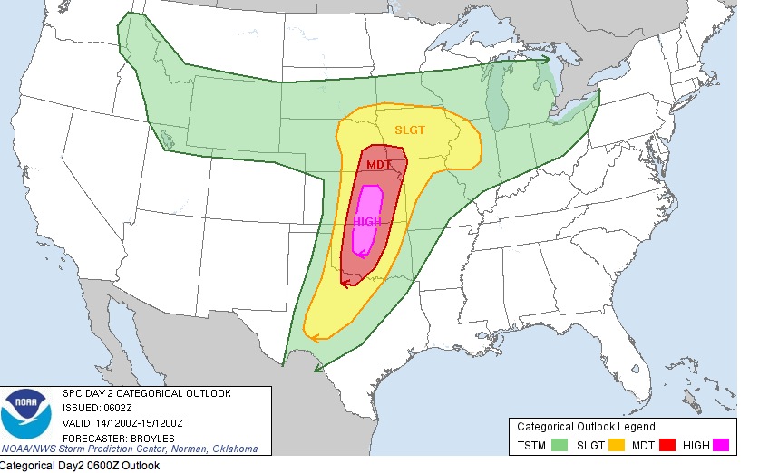
Thanks, Dan!!! We depended on you often here in North Alabama. Now I’m looking to you there in Oklahoma since our son is in Oklahoma City. I’ve ‘shared’ this forecoast.