
9 June 2011
Rare Heat Burst in Wichita
Posted by Dan Satterfield
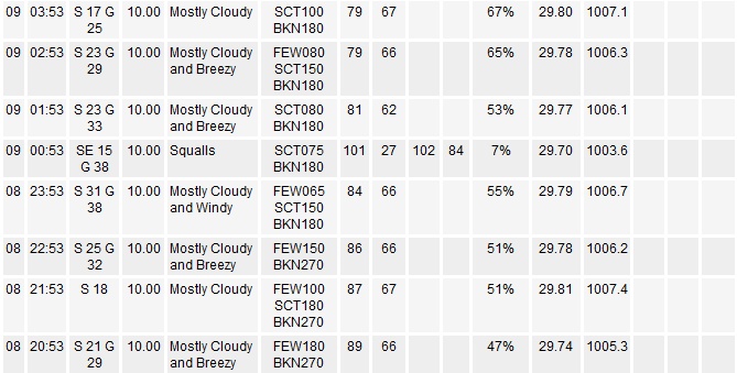
Weather obs at Wichita Airport showing the jump in temperature from the mid 80's to over 100F at 1 AM!
A rare heat burst was recorded last night in Wichita, Kansas! The temperature at midnight was 84F but an hour later, as a thunderstorm nearby died out, the temperature hit 102F! The winds gusted to over 45 mph at the same time. Needless to say it was not a night to be a lineman for the county (If you don’t get that you should really buy a Glen Campbell record)!
So what caused it?
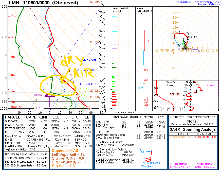
RAOB from near Wichita at 7 PM Wednesday night. The green line is the dew point recorded by the weather balloon as it rose. Notice the dry air above the surface.
There are some real clues as to the cause of these events in the upper air weather sounding (taken at 7 PM local time) from near Enid Oklahoma. Notice the the big layer of dry air just above the surface. The atmosphere was very unstable though, and thunderstorms were in the forecast. At around midnight a thunderstorm developed just south of Wichita, and set the stage for the heat burst.
As rain fell into the dry air layer at around 2-3 thousand meters above the surface, it evaporated rapidly. The evaporating rain cooled the air very quickly, and this cool air was now much heavier than the air around it. This heavy, rain cooled air, fell rapidly to the surface, but heated due to compression at the standard adiabatic rate of 10 C per 1000 meters. If it fell 2500 meters, then the temperature of that rain cooled air would have risen 25C!
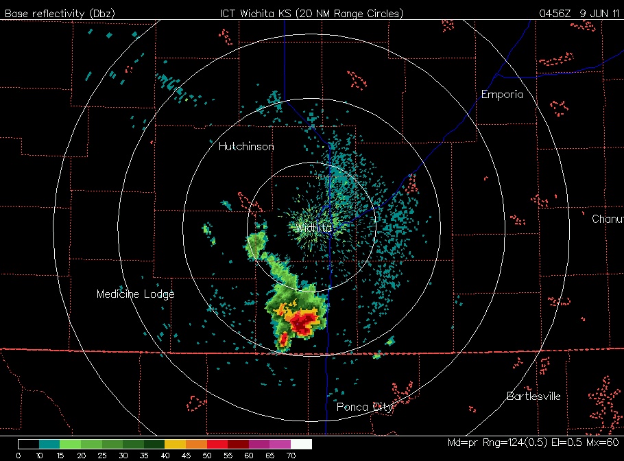
The Wichita radar shows a thunderstorm just south of the city at midnight.
 Pretty amazing isn’t it. Physics works!
 Dan Satterfield has worked as an on air meteorologist for 32 years in Oklahoma, Florida and Alabama. Forecasting weather is Dan's job, but all of Earth Science is his passion. This journal is where Dan writes about things he has too little time for on air. Dan blogs about peer-reviewed Earth science for Junior High level audiences and up.
interesting stuff! Here in Ontario, the temperature dropped from 88 F to 68 F between 3:30PM and 4:00PM yesterday, just as a storm passed through.
This is a wonderful illustration of how energy is exchanged in the mega scale Stirling engine that we live under.
Those are rare! I’ve never been in one myself. What I find most interesting is how the dewpoint fell to 27º as the heat burst arrived, leaving relative humidity of 7%!!