
21 August 2015
Friday fold: a kink fold at Baldwin Gap
Posted by Callan Bentley
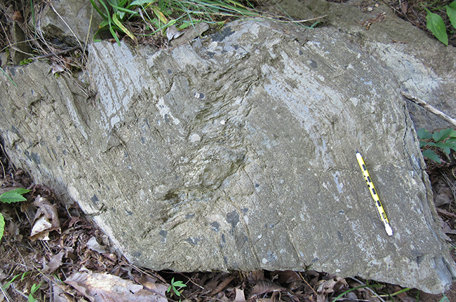
Ladies and gentlemen, I give you…
The Friday fold:
This beauty came to my attention on Monday, when I was lucky enough to go on a field trip with my friends Leigh and Mary. They are founding members of our local informal geology club, and we have been meaning to take a Cedar Creek field trip together since I moved out to the Fort Valley.
One of the sites we visited is a roadcut along the southern side of Baldwin Gap, a small water/wind gap in Little North Mountain.
While at Baldwin Gap, the question they posed to me was whether siliciclastic strata had been thrust on top of carbonates, and what unit was what.
We parked near the top of the hill (east) and walked downhill (west). We puzzled over what we were looking at – Pseudostenography of the conversation:
Was that Martinsburg turbidites?
No, can’t be Martinsburg, because here’s a quartz sandstone.
Wait, here are some redbeds – that looks like Bloomsburg. Hmmm – what unit could this be?
Sure enough, here at the bottom of the hill are limestones, including mudcracked limestones, which suggests Tonoloway Formation. Is this one unit? Two divided by a thrust fault?
…more than two…?
As far as structures go, we noted several folds (the one above was best expressed) and two small-offset reverse faults, with westward dips.
Huh.
A field experience like that, for which I had not specifically prepared, raised questions in my head, and I went home eager to answer those questions.
Fortunately, the area has already been mapped.
The Geologic Map of the Middletown, Virginia quadrangle (1999) by Orndorff, Epstein, and McDowell was the resource that confirmed our field observations and put them into a regional framework. Here’s a screenshot I took, annotated with key units, and including a detail of the thrust-faulted geology of the gap itself:
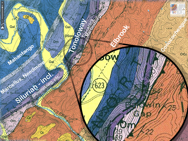
The ridge into which the gap is cut hosts not one, not two, not three, but four separate blocks, stacked up along thrust faults. This explains the diversity of llithologies we saw, and –delightfully– confirmed our assessment of which units we were seeing. Sure enough, there were clastics at the top of the hill (east), thrust on top of limestones at the bottom (west). The map-scale faults dip east, so the small-scale faults we observed were antithetic to that orientation – not an uncommon thing to observe.
The fold is probably in Tonoloway (or Helderberg?) – it was pretty much the westernmost outcrop in the gap.
This outcrop is worth sharing with the world, so in the fall or winter, when the vegetation dies back a bit, I’ll revisit it with my GigaPan.
Thanks for showing me this place, Mary and Leigh!
 Callan Bentley is Associate Professor of Geology at Piedmont Virginia Community College in Charlottesville, Virginia. He is a Fellow of the Geological Society of America. For his work on this blog, the National Association of Geoscience Teachers recognized him with the James Shea Award. He has also won the Outstanding Faculty Award from the State Council on Higher Education in Virginia, and the Biggs Award for Excellence in Geoscience Teaching from the Geoscience Education Division of the Geological Society of America. In previous years, Callan served as a contributing editor at EARTH magazine, President of the Geological Society of Washington and President the Geo2YC division of NAGT.