
12 August 2015
Student guest post: the Belt Supergroup in Glacier National Park
Posted by Callan Bentley
As longtime readers know, late summer is when my Rockies students submit their final projects – web-based explanations of key geologic sites they examined during the trip.
Today, I offer you a guest blog post by student John Leaming. You’ll notice that I’m not *completely* absent from the post, however – I make a couple of cameos as “sense of scale.”
Enjoy,
-CB
______________________________________________________________
Glacier National Park, Belt Supergroup
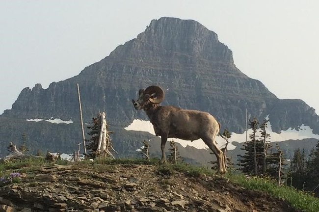
I recently traveled through Glacier National Park as part of a Field Geology Course of the Northern Rocky Mountains. The distinctive and very distinguishable strata observed throughout the park’s landscape showcase the mainly sedimentary rock that comprises the Belt Supergroup.
Click here for a map of Glacier National Park, courtesy of National Park Service.
The Belt Supergroup which comprises most of the mountains in Glacier National Park, is a thick series of sedimentary rock layers that were formed from an ancient passive rifting event about 1.6 to 1.4 Ga, where the Siberian Platform separated from the North American Craton, forming a massive Mesoprotozoic age sea basin known as the Belt Basin or Belt Sea. This basin would become the depositional location for an immense amount of sediment deposited from the surrounding landscape. Due to mass wasting and erosion, the rapidly subsiding Belt Basin was able to accommodate more than 15,000 ft. of sediment deposited ~1.47 to 1.4 Ga. Sediments such as beach sands, shallow water and fine sands, mud, silt, and limestone from varying depositional environments within the basin at the time, formed the distinctive rock layers we see today in the Belt Supergroup.
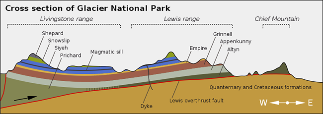
Image from formontana.net
The Formations of the Belt Supergroup
The sedimentary rock formations within Glacier National Park can typically be distinguished by their color. From oldest to youngest, the formations are: Prichard and Altyn, Appekunny, Grinnell, Empire, Helena or Siyeh, Snowslip, and Shepard.
- The Prichard Formation is found in the western portions of the park and is ~1.375 to 1.4 Ga siltstone and dark-gray argillite, which is a lightly metamorphosed mudstone, and is ~4,000 ft. thick. These rocks are roughly the same age as rocks found in the Altyn Formation, but were deposited in a deeper low oxygen water environment, resulting in its darker color.
- The Altyn Formation is found in eastern portions of the park and is composed of ~1.350 to 1.450 Ga limestone and dolomite ~780 -840 ft. thick. They are light-gray or have been weathered to a light tan.
- The Appekunny Formation is composed of ~1.375 to 1.4 Ga mudstone and argillite ~2,200 ft. thick, and are gray to light green in color due to the presence of chlorite minerals, and deposition in a slightly deeper lower oxygen environment
- The Grinnell Formation is similar to the Appekunny Formation, and is composed of sandstone and argillite ~1740-2590 ft. thick, is rich in hematite, and has a deep brick-red color. This indicates that it was deposited in a shallower oxygen rich environment. The iron content in both formations is roughly equal, and it is the depth of the water and the oxygen levels that give them their distinctive color.
- The Empire Formation is a transitional formation composed of argillite and siltite ~400-500 ft. thick. It has a combination of features of the Grinnell Formation that lies below it and the Helena Formation that lies above it.
- The Helena or Siyeh Formation is composed of ~1.1 Ga limestone and dolomite ~2460-3400 ft. thick, and is medium to dark gray in color, but often has an orange buff or honey colored weathering rind.
- The Snowslip Formation is composed of ~1 Ga red and green argillite and sandstone ~1170- 1600 ft. thick, and is only exposed at high elevations within the park. Like the Shepard Formation much of the rock that involves them has been eroded away.
- The Shepard Formation is composed of argillite, siltstones, and dolomite, and quartzite ~550-1150 ft. thick. The Snowslip and Shepard Formation make up the base pf the Missoula Group and the top two layers of remaining Belt rock in Glacier National Park.
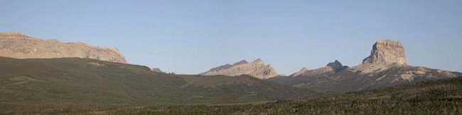
Chief Mountain
A prominent feature seen in the landscape while travelling eastward in Glacier National Park is Chief Mountain, seen at the right of the photo below. It lies in the northeastern corner of the park on the border between Glacier National Park and the Blackfeet Indian Reservation. At an elevation of 9,080 feet, its unique shape is discernable from miles away, and is regarded as a sacred location to the Blackfeet Indian Nation.
Click here for topographical map of Chief Mountain
Chief Mountain also represents a captivating example of overthrust faulting. This significant structural feature is known as the Lewis Overthrust.
The Lewis Overthrust began ~170 Ma, when Earth’s crustal plates were elevated in a mountain building event called the Sevier Orogeny. Towards the end of this orogeny, a huge slab of rock ~280 miles wide and ~3 miles thick was moved ~50 miles from the west to the east. The huge rock mass containing stronger rocks slid over the softer more easily deformed rock that lie below. The hanging wall moved up and over the footwall, resulting in much older rock being situated over younger rock.
In the photo above, erosional forces have stripped away much of the upper portion of the original Precambrian rock to the left of Chief Mountain, and this isolated remnant of the thrust sheet is called a klippe. Erosion has revealed much of the exposed rocks and structures seen in Glacier National Park today.
The opposite of a klippe is called a fenster, where a portion of footwall is entirely surrounded by hanging wall. It is a tectonic window that has eroded through to lower rock. It should be noted that that this geologic structure does not present itself in the area of Glacier National Park.
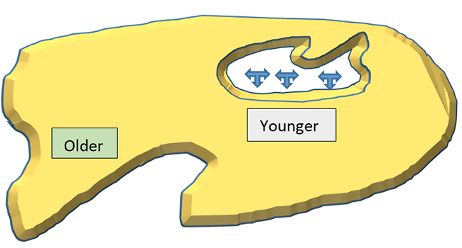
In the depiction created above, the fenster can be seen on the right as an eroded opening into the underlying rock.
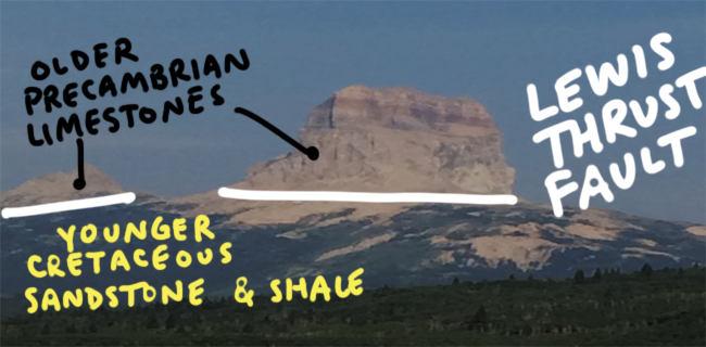
In this photograph of Chief Mountain taken from the east, the upper plate of overlying Precambrian rocks are more than 1.4 billion years older than the underlying Cretaceous age rocks. Chief Mountain is composed of belt rock from the Altyn and Appekunny formations. The Lewis Overthrust is visible at the base of the Altyn Formation.
Most of the sedimentary rocks from the Belt Supergroup seen in Glacier National Park are Mesoproterzoic in age, and were deposited around 1.45 Ga to 800 Ma. Unlike other areas that have undergone mountain building, these rock formations in the park have preserved many of the characteristic features of sedimentation.
A photo of mud cracks from the Grinnell Formation on the way to Grinnell Glacier. These mud cracks were formed under the same conditions found today in areas exposed to wet, then dry conditions.
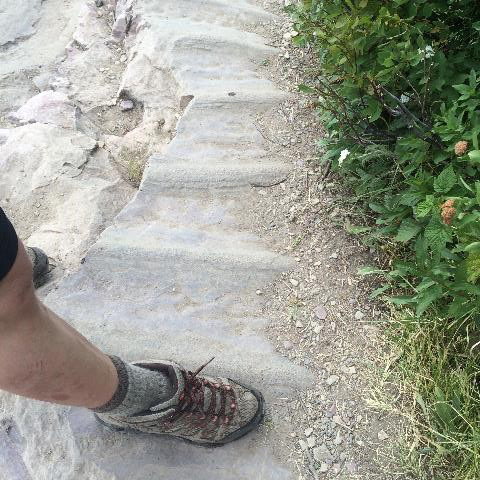
A photo of oscillatory ripple marks captured in the Grinnell Formation. These shallow water features are the result of gentle wave action in the fine silty clay.
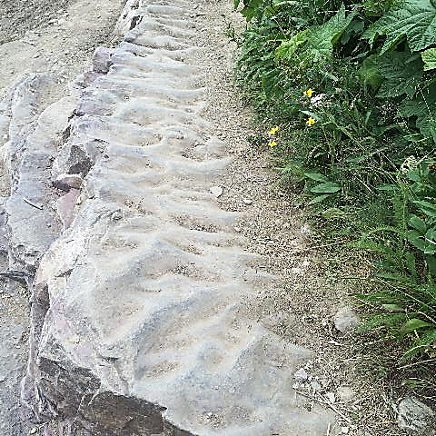
Another photo of ripple marks in the Grinnell Formation along the way to Grinnell Glacier.
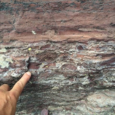
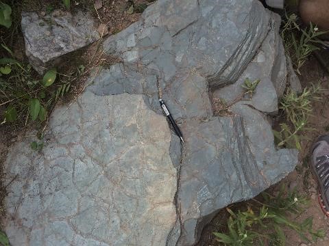
This photo shows mud chip rip-up clasts in the Grinnell Formation, and is indicative of an ancient storm. The high energy currents carried sand and ripped up clay particles which were deposited into the muddy surroundings.
Stromatolites
Within the Helena Formation, a fossilized bacterial life called stromatolites can be observed in the sedimentary layers and rock outcrops. They are a cyanobacteria blue-green algae that grew in the relatively warm, shallow waters of the Belt Basin, and their existence can be traced back more than 3.5 Ga, making them one of the oldest lifeforms on this planet. They lived in mat-like colonies and would precipitate limestone on fine sediments onto successive layers. As they continued to grow higher in an effort to reach sunlight, they created their distinctive dome shaped appearance. Stromatolites generate a layer of protective slime that covers their cells, and a new layer can be generated when the old layer gets covered in too much sediment. These dome shaped layers are often referred to as a cabbage heads. Due to the abundant volume of stromatolites during this time, they are responsible for producing much of the oxygen in the Earth’s atmosphere at that time, by consuming carbon dioxide in the water, and releasing oxygen through photosynthesis. The Altyn and Snowslip Formations also contain beds of stromatolites, but the best examples seen in the park are undoubtedly seen in the Helena Formation.
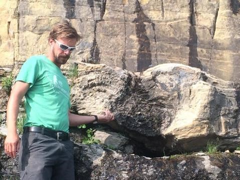
A lesson on the stromatolite layer along Going-to-the-Sun Road, being taught by Professor Callan Bentley. This stromatolite layer is ~3 feet high and 25 feet long.
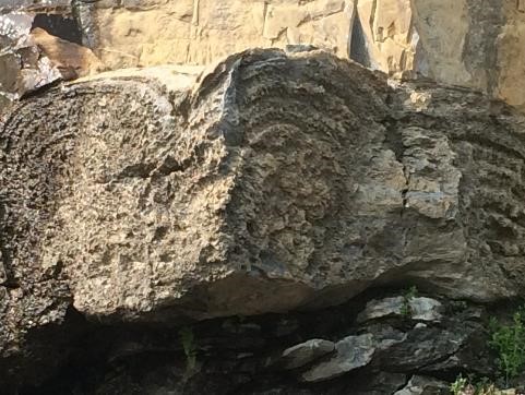
A closer cross-section view reveals the intricate layers within the matting, and the distinctive dome shape, also called cabbage heads. Note the buff color of the weathered Helena limestone visible above the layer of stromatolites.
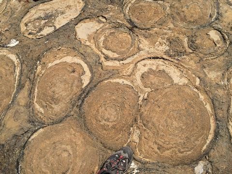
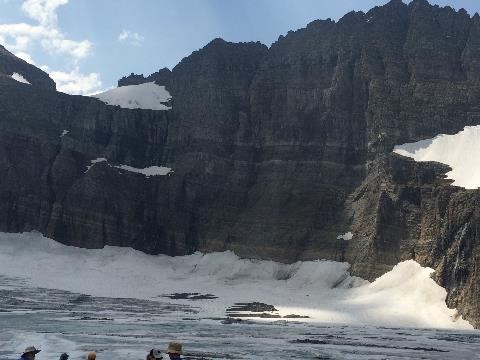
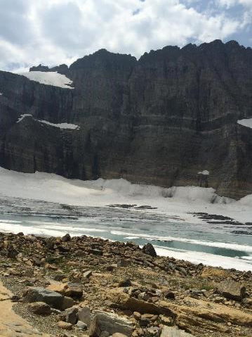
This huge exposure of honey-colored stromatolites are found in the Helena formation at Grinnell Glacier. These stromatolites have been ground down over time by the glacier, providing a unique view above this particular colony.

One final picture of the stromatolites with Professor Callan Bentley, which conveys just how expansive this layer at Grinnell Glacier is.
The Purcell Sill
Not all of the distinctive rock layers in Glacier National Park are sedimentary in origin. The dark band that stands out in stark contrast throughout most of the strata within mountains seen in the park is called the Purcell Sill. It is a 130-250 ft. layer of fine grained mafic igneous rock called diorite, which intruded between the layers of lighter colored limestone. The younger 725-775 Ma intruding sill, contact metamorphosed and baked the surrounding 1.1 Ga limestone of the Helena Formation, creating its bleached appearance.
The Purcell Sill shown here at Grinnell Glacier stands out in stark contrast as the black stripe in the middle of the strata.
Another picture of the diorite sill found within the Helena formation at Grinnell Glacier. Note the light colored limestone that has been contact metamorphosed above and below this intrusion.
Looking Glass Road
This outcrop located just outside of Glacier National Park, contains a variety of young sedimentary deposits that range from fine silt beds that crumble in your hand, to lithified beds containing siltite and larger size rocks and cobbles that have been tilted nearly 90 degrees. These layers of strata were deposited as a result of the last ice age during the Pleistocene that ended ~12 ka.
Click here to see the Google Map location
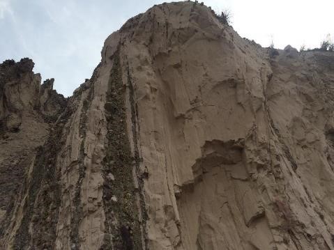
This picture shows the vertical bedding of fine glacial powder, siltstone, and glacial till within the outcrop.
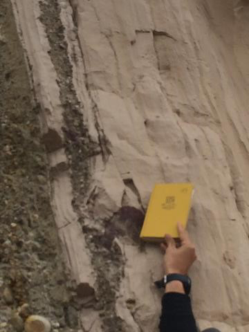
This picture shows the finer grained siltstone, which results from the depositing of glacial powder. There is evidence of dropstones where fragments of rocks drop out of a glacier, and are deposited into the finer grained sedimentary layer below.
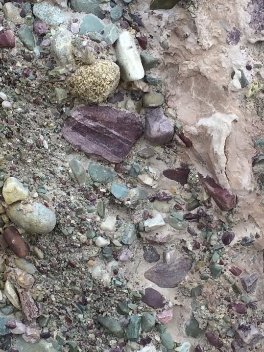
This picture shows a close-up of the beds composed of small rocks and cobbles, which are likely the result of glacial till that was transported and deposited by a glacier
Here is a synopsis of what occurred at this outcrop. After the glacier deposited its end moraine, the glacier retreated. As it melted, it deposited fine powdery silt that settled out in a glacial lake. Dropstones were transported, or floated out into the lake within pieces of the glacier, where they dropped into the silt as the glacial pieces melted. Additional gravel and small rocks were deposited in the lake by glacial outwash. The glacier then advanced, acting like a bulldozer, and scraped up all the lake sediments that were deposited previously in its path. The glacier receded a second time, and after melting away, left the vertical beds of sediment made up of the silt, gravel, cobbles, and dropstones seen here along the Looking Glass Road. It is fascinating to see, that the tilting of these beds are so unique, when compared to other structures within the park associated with mountain building.
 Callan Bentley is Associate Professor of Geology at Piedmont Virginia Community College in Charlottesville, Virginia. He is a Fellow of the Geological Society of America. For his work on this blog, the National Association of Geoscience Teachers recognized him with the James Shea Award. He has also won the Outstanding Faculty Award from the State Council on Higher Education in Virginia, and the Biggs Award for Excellence in Geoscience Teaching from the Geoscience Education Division of the Geological Society of America. In previous years, Callan served as a contributing editor at EARTH magazine, President of the Geological Society of Washington and President the Geo2YC division of NAGT.
A well-done virtual geologic tour, especially because I led our University of Washington summer field course to Sun River and Glacier, and some of your stops, in mid-July. We camp at the St. Mary’s KOA. However, I was really disappointed at the volume of traffic. The parking lot at Logan Pass closed at 10:45 a.m. It is also extremely difficult to find parking space for five vehicles on Going-to-the-Sun road at some of the geologically superb stops: the stromatolites, the Grinnell, and the Altyn. I think the park, given its limited resources, can find ways to be more welcoming to geologists.