
4 July 2014
Friday fold: Warspite Anticline
Posted by Callan Bentley
A final guest Friday fold from reader Howard Allen, who I’m pleased to be meeting up with in Banff late next week…
Howard writes the following in describing this lovely scene:
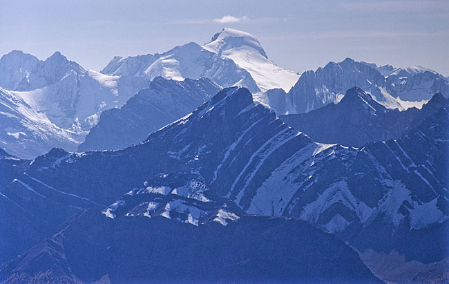
Warspite Anticline, Peter Lougheed Provincial Park, Alberta. Photo is a telephoto shot (hence the strong blue alpine haze–the colour cast is an accurate rendition of the original daylight Kodachrome slide), looking southwest at an angle to regional strike. The peak at top centre is Mount Joffre, the highest peak in the area. The dark peak in centre, on the left limb of the anticline, is Mount Warspite. Photo was taken in 1998 from the summit of the north end of “Kent Ridge” (= the western ridge of Mount Inflexible) at 50.7706, -115.2210. The peaks in the middle ground, with nearly vertical bedding, between Mt. Warspite and Mt. Joffre, belong to Mount Lyautey. This view shows the opposite (north) side of Lyautey, and the Lyautey Syncline. The syncline axis is hidden in this view by the peak of Mount Warspite, but you can see it on the next range south, forming a snow-covered col on the left side of the photo, about 1/3 the way down from the top.
Thanks, Howard! See you next week!
To everyone else:
- Happy Friday!
- Happy American Independence Day!
- Happy Final Friday Fold For Now… I’ll resume the blogging in August after I get back from travels out in these same mountains.
 Callan Bentley is Associate Professor of Geology at Piedmont Virginia Community College in Charlottesville, Virginia. He is a Fellow of the Geological Society of America. For his work on this blog, the National Association of Geoscience Teachers recognized him with the James Shea Award. He has also won the Outstanding Faculty Award from the State Council on Higher Education in Virginia, and the Biggs Award for Excellence in Geoscience Teaching from the Geoscience Education Division of the Geological Society of America. In previous years, Callan served as a contributing editor at EARTH magazine, President of the Geological Society of Washington and President the Geo2YC division of NAGT.
The sedimentary expressions in the Canadian Rockies is just amazing. Plus what a great contrast between original earth structure and the random torn remnants left after erosion takes over at the surface.