
6 August 2014
Guest post: Glaciolacustrine deltas in the Canadian Rockies
Posted by Callan Bentley
[guest post by Maddy Rushing, George Mason University, one of Callan’s students this year in Regional Field Geology of the Canadian Rockies]
The Canadian Rockies are well known for their superb glaciated landscapes and active ice fields. Not so well known, are the glaciated landforms that lay beneath the surface. Observing the rock record and numerous outcrops throughout these mountains, one can find a map of the past.
First, we will take a look at modern day glacial deltas to be seen in the Canadian Rockies today. Peyto Lake in Banff National Park, Alberta. The image below from Google Maps depicts Peyto Lake as a glacial-fed lake having its primary inflow from Peyto Creek which drains water from the Caldron Lake and Peyto Glacier and finally flows north, into the Mistaya River.
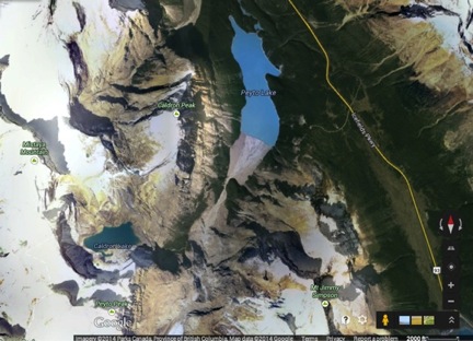
The delta of focus is located at the southern most end of Peyto Lake. This delta is of ice-contact variety for its deposition occurs at the margin of the glacier. The sediment being deposited at this delta accumulates from various locations regarding the glacier. Most of the sediment travels through subglacial rivers or streams, however the glacier itself transports some sediment on its own.
Here is a closer look at the delta: (zoomed in from Google Maps)
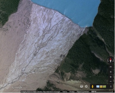
The GigaPan below (by Callan) shows the delta from a profile view. Looking closely, you can see the dendritic drainage system typical of deltas.
And as you can see, the location is quite beautiful.
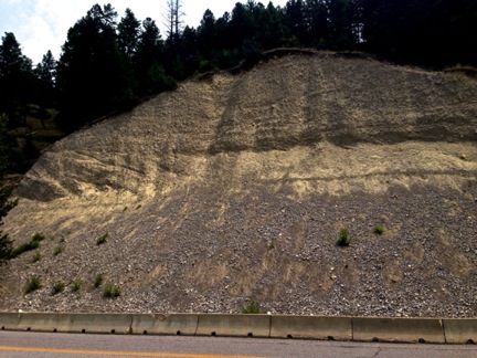
Outcrops can provide a great visual representation for how these deltas form and show what they look like so that geologists may be able to find them in other locations to better understand the geological changes that a certain area has undergone. The following outcrop was found in Kootenay National Park, right outside of Radium Hot Springs.
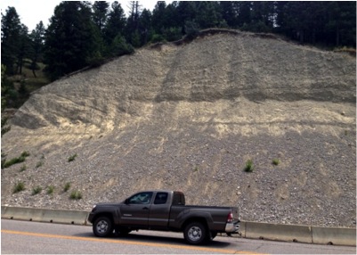
These are sediments we interpreted as having been deposited by a prograding glaciolacustrine delta. The delta likely was formed during one of the more recent of numerous glaciation periods in the Canadian Rockies; perhaps the Illinoian? Considering the outcrop has not been dated and assuming it was in fact formed during the Illinoian Glaciation, it is reasonable to infer that the approximate age of this outcrop is 130,000 years. This delta is a coarse grained lacustrine delta as opposed to a marine delta with gentle slopes and fine grained sediment such as the Mississippi Delta. These coarse grained deltas are known as Gilbert Deltas (named after Grove Karl Gilbert of USGS) and are characteristic of rivers or streams coming into contact with freshwater lakes. Gilbert Deltas have three stratigraphic components: a topset, foreset, and a bottomset. The picture below shows the orientation of these beds.
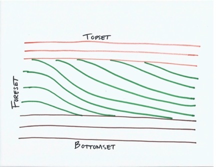
Topset beds are deposited by streams or distributaries, typically consisting of coarse- grained sediment that leaves a horizontal layer across the top of a delta. Foreset beds are found below the topset beds and are deposited by sediment that was carried down the end of a delta into deeper waters than the topset beds and thus are a bit more fine-grained as well. Foreset beds characteristically have a slight angle that suggests the direction of flow and delta growth. Finally, the horizontal bottomset beds underlie the foreset beds and are deposited in deeper, calmer waters leaving the finest delta sediment. The sequence of these beds provide an exquisite deltaic cross-section such as this one on Kootenay Highway.
The image below is a better look at this outcrop:
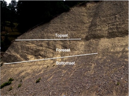
Unfortunately, there was not ample enough time to spend at this outcrop to get images of better quality or ones that incorporate scale (here’s a link to GoogleMaps StreetView of the outcrop: Kootenay Hwy Glacial Delta Outcrop). Regardless, the stratigraphic relationship is clearly recognizable. An annotated image of a zoomed in portion of this outcrop is depicted above, showing the relationship between the three stratigraphic components.
Observing this outcrop, allows us to interpret this area as a pervious glaciolacustrine delta similar to the modern day glaciolacustrine delta seen at Peyto Lake. Making these observations is important within the geological field because it allows us to compare and contrast the type(s) of environment(s) a particular area has confronted, ultimately to better understand the geological changes of that area. The Canadian Rockies is a great place to go to make these observations as well as enjoy the area on it’s own.
 Callan Bentley is Associate Professor of Geology at Piedmont Virginia Community College in Charlottesville, Virginia. He is a Fellow of the Geological Society of America. For his work on this blog, the National Association of Geoscience Teachers recognized him with the James Shea Award. He has also won the Outstanding Faculty Award from the State Council on Higher Education in Virginia, and the Biggs Award for Excellence in Geoscience Teaching from the Geoscience Education Division of the Geological Society of America. In previous years, Callan served as a contributing editor at EARTH magazine, President of the Geological Society of Washington and President the Geo2YC division of NAGT.