
25 August 2010
Jointed Virgelle
Posted by Callan Bentley
One of the stops my Rockies students and I made this summer was a dinosaur paleontology tour through the Two Medicine Dinosaur Center in Bynum, Montana. The folks there are very accommodating, and at my request gave the class a bit of stratigraphic context for the dinosaur fossils. For instance, we visited the geologic formation which underlies the dinosaur-bearing Two Medicine Formation: it’s a beach sandstone called the Virgelle Formation. The Virgelle was deposited along the shore of the Western Interior Seaway, a Cretaceous-aged transgression of seawater onto the North American continent.
While our guide Corey discussed the primary structures that showed the unit to be “beachy” to my students, I got distracted by this outcrop:
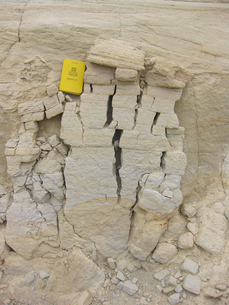 Field notebook for scale (long side 18cm).
So what’s so great about this? It struck me as a nice little demonstration of the relationship between stress directions and joint orientations. σ1 is our maximum principal stress direction (i.e., the direction of greatest stress), in this case caused by acceleration due to the force of gravity. σ2 is perpendicular to the screen of your computer (and the plane of the photograph): that is the intermediate principal stress direction. σ3 is our minimum principal stress direction (weakest stress), in this case pushing in from the sides (atmospheric pressure only, no overlying rock weight):
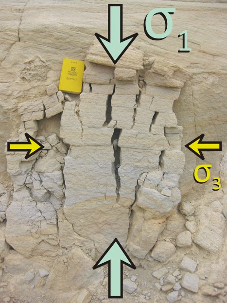
By definition, σ1 is greater than σ3.
So we have a low-level confining stress paired up with the differential stress imparted by the heavy rock pushing down on the slab of sandstone beneath it. As long as that difference in stresses is greater than the strength of this weakly lithified Virgelle sandstone, then the rock will break, and the orientation of those breaks will be ~parallel to σ1, and ~perpendicular to the extension direction, σ3:
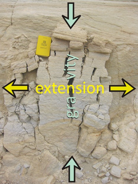
You’ll also note that the bedding planes in the Virgelle sandstone are planes of weakness, accommodating the extension by allowing blocks of sandstone to slip sideways over what amount to small-scale “detachment faults” (low-angle, upper block sliding downward relative to lower block).
So does an understanding of these stress directions and the resulting structures’ orientation do us any good beyond this one lone slab of fractured sandstone?
Indeed it does. Keeping in mind that we are rotating our perspective from horizontal (“side view”) to vertical (“bird’s eye view”), consider the following map of central Asia:
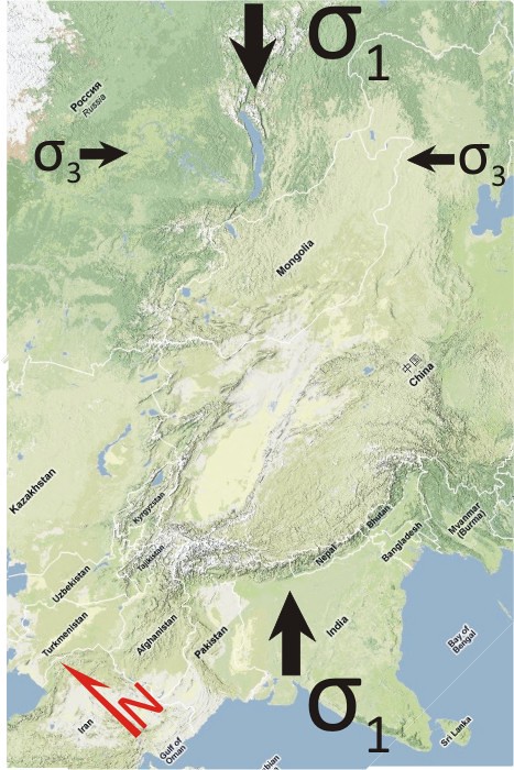
As the Indian subcontinent impacts the Eurasian continent, it moves towards the northeast. This results not only in the northwest-southeast-trending Himalayan mountain front at the site of impact, but also in extensional faulting further into the heart of the continent. Down-dropped blocks of crust in desert areas show up as northeast-southwest-striking rift valleys, but in wetter areas, those low-lying cracks fill with water, and show up to us as linear lakes.
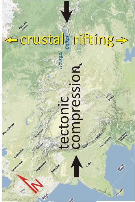
Lake Baikal in Russia is a famous example of this, but Mongolia’s Lake Hovsgol is a smaller version of the same thing. The lakes are oriented with their long axis ~parallel to the σ1 direction, as they have been opened up due to stretching in the σ3 direction.
Caveat blog-reader: The kinematics and dynamics of central Asia are actually a lot more complicated than this simplistic picture I’ve painted. My main point in drawing the parallel between the two examples is that outcrop-scale structures can serve as analogues that can help us understand regional-scale processes.
 Callan Bentley is Associate Professor of Geology at Piedmont Virginia Community College in Charlottesville, Virginia. He is a Fellow of the Geological Society of America. For his work on this blog, the National Association of Geoscience Teachers recognized him with the James Shea Award. He has also won the Outstanding Faculty Award from the State Council on Higher Education in Virginia, and the Biggs Award for Excellence in Geoscience Teaching from the Geoscience Education Division of the Geological Society of America. In previous years, Callan served as a contributing editor at EARTH magazine, President of the Geological Society of Washington and President the Geo2YC division of NAGT.