
20 April 2008
Piedmont geology along the Billy Goat Trail
Posted by Jessica Ball
On Saturday, I had the opportunity to go on a great geology hike with Callan Bentley in the C&O; Canal National Historical Park, which follows the Potomac River where it becomes fast, deep and narrow and flows through Mather Gorge. The park is divided between Virginia (the Great Falls National Park portion) and Maryland, and the Billy Goat Trail (so named because it involves a tiny bit of scrambling) parallels the Potomac on the Maryland side. Having visited the Virginia side for an undergrad geology trip, I have to agree with Callan that Maryland side has much more to offer – including some very exciting exposures of a rock that Callan, who’s traveled all around the world, has only seen in two places. (About the only thing Virginia has that Maryland doesn’t is the high water level pole, and that just doesn’t measure up. Har.)
Great Falls is a wonderful place for a field trip because its history spans more than 500 million years, including three orogenies, a few ice ages, and even historical alterations to the land. One of the latest geologic maps published by Southworth and Fingeret of the USGS (2000) can be found here, with more detailed descriptions of some of the units I’ll be discussing. (If I get anything wrong, it’s because of my own rusty memory, and not Callan – he gave a stellar tour!)
The units we encountered on the hike included metagraywacke, granite, lamprophyre, amphibolite, and various visitors from the Blue Ridge. Here we go:
Some sexy folding in Lower Cambrian metagraywacke. Graywacke is basically a “dirty” sandstone: instead of being purely quartz grains (as in quartz sandstone), or quartz and feldspar (arkosic sandstone), it contains clay. When it’s metamorphosed, the clay becomes muscovite or biotite mica, which shows up in the darker stripes. This unit was deposited by turbidity currents in an ocean basin (you can see graded bedding sequences in some places), and during the Taconian orogeny was smashed between the North American continent and an incoming volcanic island arc. The compressional stresses created the prominent folding seen here.
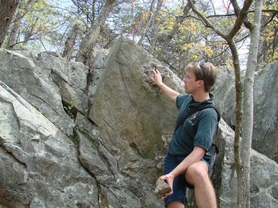 Hydrothermally deposited quartz veins in the metagraywacke. Some of these can contain gold – there was even a gold mine in the park area from 1865 to 1940.

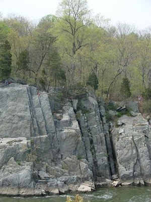
This photo shows the Virginia side of the river, where several Late Devonian lamprophyre dikes have intruded into the metagraywacke. The joints in the graywacke reached deep enough into the crust that they tapped into hot (but not molten) rock; the rock “took advantage” of the situation and, melting as it rose higher in the crust and decompressed, filled in the joints. What’s fascinating about these dikes is that, although they are present on both sides of the river, they don’t line up. So what gives? If one theory is to be believed, the bedrock in the riverbed, in the form of a right-lateral fault. Evidence in favor of this includes the Mather Gorge itself, which is straight enough to line up with a ruler (if the ruler were half a mile long). Unfortunately, it’s impossible to see – the river is too fast to dive in, and the bottom is covered with mud and really big boulders – and it doesn’t outcrop anywhere that Callan was able to find. Another possibility is that the dikes are not straight but kinked where the river crosses them – again, impossible to test without making all the water and mud and rocks disappear.
 Even more sexy folding in metagraywacke.

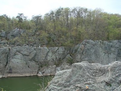
Strath terraces marking the ancient riverbeds of the Potomac, and a good example of why you can’t apply superposition to everything. These straths are evidence of downcutting by the river in periods of low sea level (ice ages). The very top ledge indicates the position of the oldest riverbed; the next one down represents the lowest level the Potomac incised to during one ice age, and where it stopped for some time. Then another ice age came along, and the river incised downward again to the level it is currently at. This photo shows other evidence of where the river once was: a dissected pothole. The river is actually currently capable of reaching this height during floods, but because potholes take long periods of abrasion to form, we know this one is a feature of the ancient riverbed and not modern flooding (which is relatively short-lived).
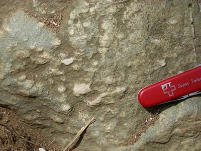
 The aliens have landed! Well, not really, in the xenolith sense. But it is a visitor from far upstream – a chunk of the Catoctin Formation, a Blue Ridge unit of Neoproterozoic age. The Catoctin is composed of greenstone (metamorphosed basalt),
and contains lots of chlorite and epidote (which give it the blue-green and pistachio mottling).
 This particular boulder is really neat, because it contains quartz-filled amygdules (not vugs, thanks for reminding me, Callan! It’s amazing what I can forget in a year…). The amygdules show that the basalt was originally vesicular; they managed to survive the metamorphism and get filled with quartz (and maybe some calcite?) later on. Original flow features, yay!
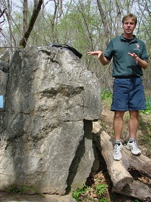
THE coolest rock on the hike. Callan’s already talked extensively about these, so I won’t elaborate much more on migmatites, but suffice to say that it’s absolutely amazing to see granite “sweating” out of a metamorphosed sedimentary rock. This boulder also shows some really great little deformation features, in the form of folding and boudinage, or little pinched out “sausages” of quartz. That rock’s been through a rough life: bulldozed, squeezed and roasted.


Another visitor from afar: a boulder of Blue Ridge granite containing blue quartz (pretty rare stuff!) This is likely Old Rag granite, formed during the Grenvillian orogeny more than a billion years ago.

Another favorite stop, this is an isolated outcrop of amphibolite, or metamorphosed gabbro. The pebbly texture is a result of large crystals of amphibole (of course). The working hypotheses for this location are A) the gabbro was injected as a sill into the metagraywacke/graywacke and then metamorphosed, or B) that the gabbro was already present on the subducting oceanic plate during the Taconian orogeny, and was scraped up as part of the accretionary wedge and metamorphosed with the sediments.
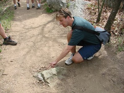
 Callan’s pointing out another great example of deformation: parasitic folds and boudinage in a larger, almost isoclinal fold.
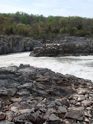
 A view of the joint sets at Great Falls. There are at least 6 different sets in the area, although none of them actually line up with the river – another good argument for a fault running through Mather Gorge.
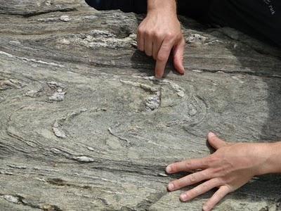
So why are the quartz veins so parallel here? While they could have been originally emplaced that way, the reality is actually much cooler: These veins are folded completely back on each other, and then folded again. The first deformation (F1) created isoclinal folds, and the second (F2) created the tight, or “squiggly” part of the folds.

I didn’t realize just how much I missed going on geology field trips – or how easy it is to let your mind drop out of “geology mode”. I’m glad for the refresher, and for the chance to get used to thinking on my toes again. (I am not so glad that I managed, somehow, to acquire a dozen itchy spider bites. I’m not dead, so I’m assuming they aren’t poisonous, but about half of them are in places on my back that I can
‘t reach, and they’re driving me nuts. Guess I should start marinating myself in DEET again.)
By the way, Callan will be leading a few more of these hikes, so if anyone’s in the DC area, check out the schedule and sign up!
 Jessica Ball is a volcanologist at the U.S. Geological Survey, researching volcanic hydrothermal systems and stability, and doing science communication for the California Volcano Observatory. She previously worked at the Geological Society of America's Washington DC Policy Office, learning about the intersection of Earth science and legislative affairs. Her Mendenhall postdoc and PhD focused on how water affects the stability of volcanoes, and involved both field investigations and numerical modeling applications. Her blogging covers a range of topics, from her experiences in academic geosciences to science outreach and communication to her field and lab work in volcanology.
[…] I wrote a post a while back on the hike that I took with Callan along the Billy Goat Trail on the Maryland Side of the Falls. As I mentioned there, Great Falls cuts into bedrock in the Piedmont province, mostly Lower Cambrian metagraywackes (that’s metamorphosed ‘dirty’ sandstone without the fancy terms). The ‘dirty’ part is actually clay in there with the quartz sand that formed the original sandstone; when it metamorphoses the clay becomes muscovite or biotite mica. The graywackes at Great Falls were deposited by turbidity currents in an ocean basin (you can see graded bedding sequences in some places), and during the Taconian orogeny they were smashed between the North American continent and an incoming volcanic island arc. (If you’d like the full history, go read Callan’s excellent “Geology of the Billy Goat Trail” handout.) […]