
1 April 2021
Düzce Zonguldak: a spectacular retaining wall failure on a highway in Turkey
Düzce Zonguldak: a spectacular retaining wall failure on a highway in Turkey
On 26 March 2021 a spectacular retaining slope failure occurred on a highway at Düzce Zonguldak in Turkey. I haven’t seen any images of this failure in the UK media, which is a shame as it is an unusual event. Haber Golkoy has this image of the landslide:-
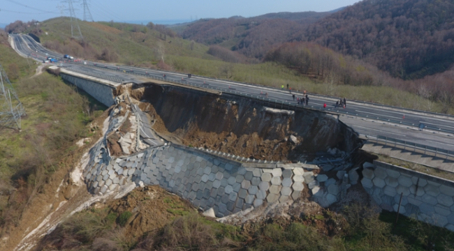
The highway slope failure at Düzce Zonguldak in Turkey on 26 March 2021. Image from Haber Golkoy.
.
According to the news reports the slope failed overnight. No-one was hurt. Unsurprisingly, the road is now closed, with traffic being diverted onto local roads. This view, from an image posted by Cumhuriyet, provides a better idea of the materials involved:-
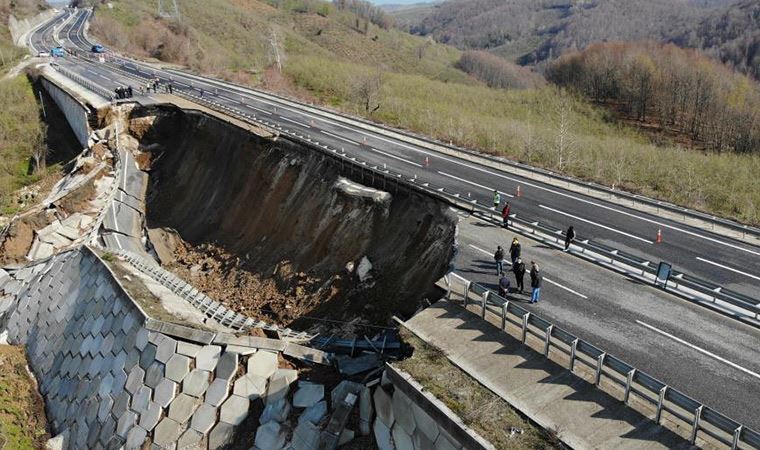
, A close up view of the highway slope failure at Düzce Zonguldak in Turkey on 26 March 2021. Image from Cumhuriyet.
.
It is interesting that the road has been built across a topographic depression on an embankment made from fill. I am no expert on retaining structures – is this a mechanically stabilised retaining wall? [In the comments below Fabien Peyrel has confirmed that this is a Mechanically stabilized earth (MSE or reinforced soil) structure]. The wall has slumped spectacularly.
Scenarios for this event here could include failure through the foundation of the structure (a bearing capacity failure) and/or a build up of excessive pore water pressures in the fill causing a fillslope failure. The latter would imply inadequate drainage of the fill, either because of poor design or construction, or because of poor maintenance. Again, I would be very interested in the views of others in the comments.
The news reports suggest that the road at Düzce Zonguldak was opened in 2012. The highway was reportedly constructed by Limak Holding.
Clearly reconstruction of this highway is going to be a substantial task. If the failure is the result of a design, construction or maintenance error then other sections of the road may well be at risk too.
30 March 2021
The resilience of rail infrastructure: reports from the Network Rail earthworks and weather advisory task forces
The resilience of rail infrastructure
On 12 August 2020 a very serious rail accident occurred at Carmont near to Stonehaven in Scotland when a fast-moving train struck a pile of debris on the track. The train derailed, with some of the set crashing down an embankment. Fortunately the train had only nine passengers and crew onboard, but sadly three of them were killed.
The accident occurred on a section of track that had been subject to a number of landslides and other geotechnical failures in recent years, and it happened during a well-forecast period of heavy rainfall. Inevitably this focussed attention on the state of the geotechnical assets managed by the UK rail infrastructure operator, Network Rail. It also raised questions about the viability of an early warning system for heavy rainfall events on the rail system.
In the aftermath of the accident, the Secretary of State for Transport commissioned two reports in addition of course to the accident investigation. These reports were:
- An Earthworks Taskforce Management report led by Lord Robert Mair
- A Weather Advisory Taskforce Report led by Dame Julia Slingo
In addition, Network Rail have produced a report providing an update on the Resilience of Rail Infrastructure.
The reports have now been published online. I’m going to state clearly an interest here as I was a member of the Earthworks Taskforce, and indeed within that report there is a separate report on The Role of Technology in Slope Management that I authored.
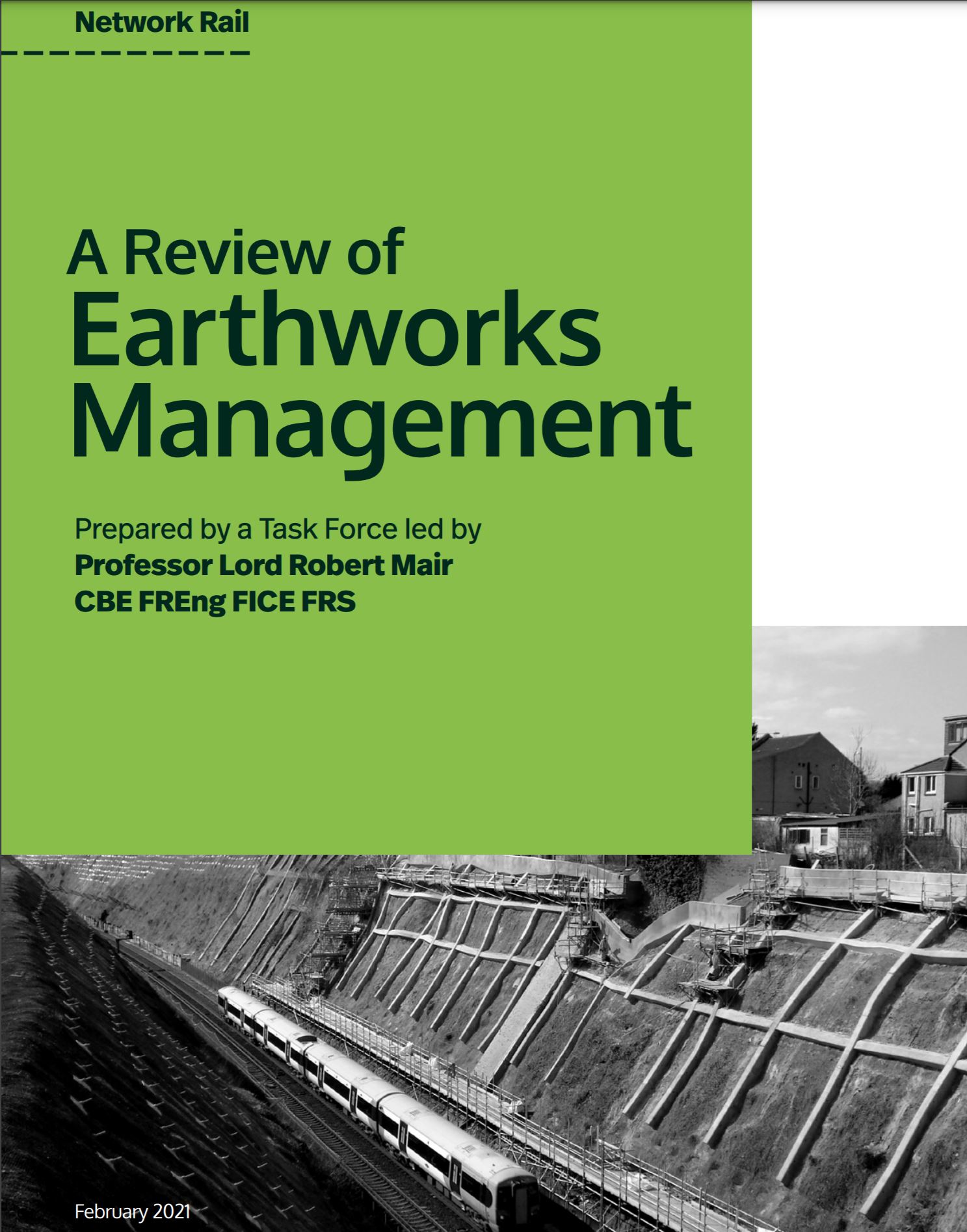
The front cover of the Network Rail report on Earthworks Management
As I was a member of the Earthworks Management task force I’m not going to comment on the reports – that is for others. It it is, I believe, an exceptionally detailed and comprehensive review of the topic (including the appendices it runs to over 540 pages). It provides an excellent history of the development of earthworks on the UK rail system, the mechanisms of failure, management approaches and potential areas of research.
I think the two reports will be considerable interest to a wide variety of people, not just those in the UK and those working on rail networks.
The Executive Summary of the Resilience of Rail Infrastructure report makes the following key observation:
Most earthworks and drainage beside our railway were built more than 150 years ago. They were constructed without detailed engineering design and not to current standards at a time when the risks associated with earthworks were not scientifically understood. Consequently, cuttings and embankments were constructed with steep and unreinforced slopes. Commonly, drainage systems were not built with the original earthworks and the drainage that was installed was not designed to cope with floods. While they have served us well, and despite many improvements over the years, they are not as robust as a modern-day equivalent. Earthworks structures are complex to manage due to underlying geology, adjacent environments and assets, local weather patterns and a propensity for very localised failure. Rebuilding thousands of miles of earthworks and drainage systems to modern-day standards is not practicable, either from a funding or deliverability perspective.
The magnitude of the challenge is very clear, but these two reports are intended to provide a clear roadmap to keep the UK railways safe.
29 March 2021
Yarlung Tsangpo: another giant, high mountain landslide on 22 March 2021
Yarlung Tsangpo: another giant, high mountain landslide on 22 March 2021
On Friday evening, as I was queueing to receive the first dose of the Oxford / Astra Zeneca vaccine for Covid-19 (a wonderful day), I received an email from Göran Ekstrom of Columbia University making a small group of us aware that he had detected, using seismic instruments, a probable large-scale landslide in the vicinity of the Yarlung Tsangpo in Tibet. As always, the seismic data gives an indication of location, but not a precise grid reference, and an idea of the mass (in this case about 100 million tonnes – a very large one indeed).
Fastest out of the blocks was Marten Geertsema, who used partially cloudy Planet Labs satellite imagery to identify a possible site. Yesterday, Planet Labs data with low levels of cloud became available. Dan Shugar from the University of Calgary was able to identify that the location was correct, and that a large landslide had occurred:-
https://twitter.com/WaterSHEDLab/status/1376247670419808259
.
This is the Planet Labs image of the site, captured yesterday:
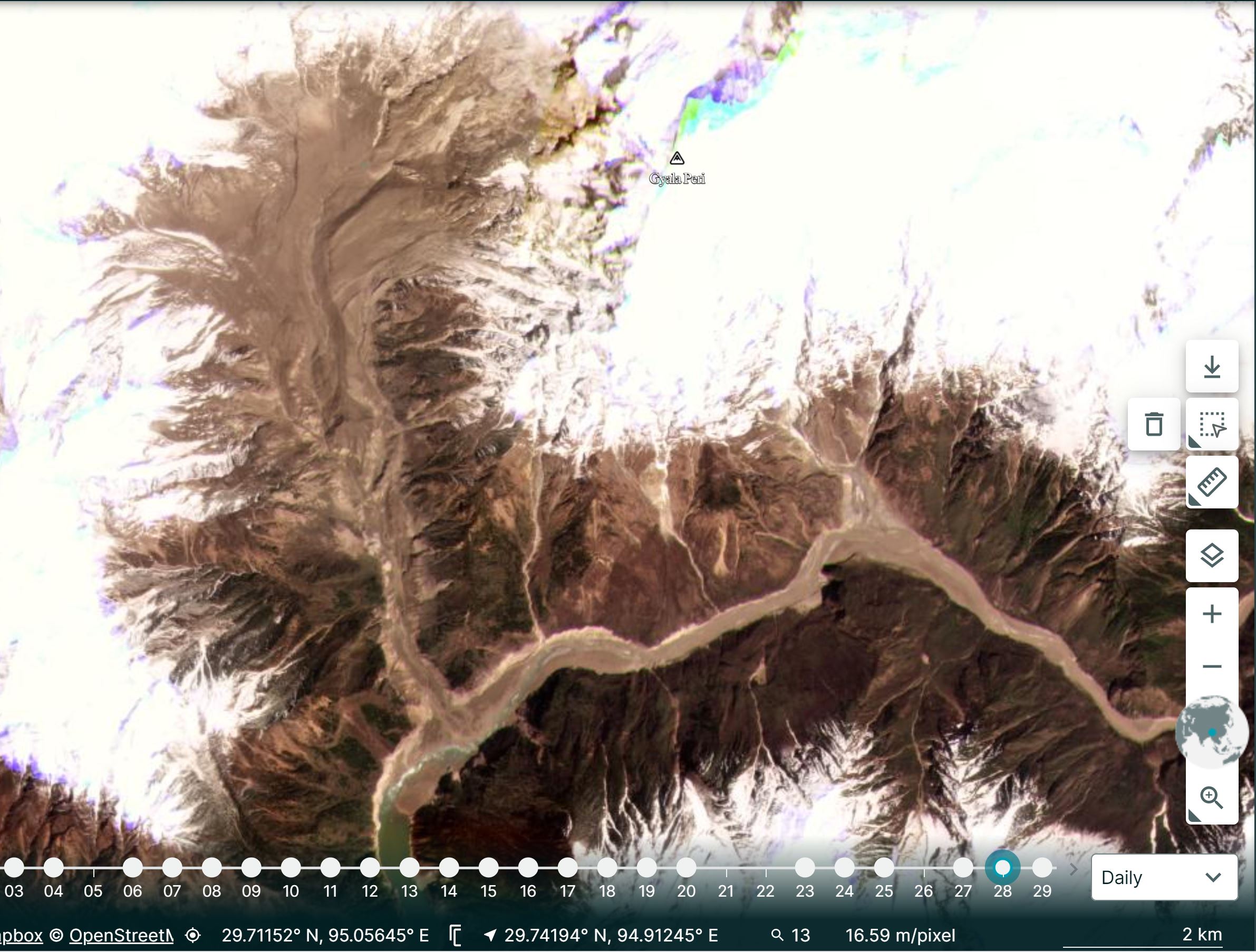
Planet Labs image of the 22 March 2020 landslide at Tsangpo in Tibet. Image cop right of Planet Labs, used with permission.
.
The coordinates of the site, 29.815, 94.932 are the centre of the landslide source. Note the scale in the bottom right corner.
Dan and I slightly disagree with how this (and Chamoli) should be described (which is fine of course). Dan describes this event as the collapse of hanging glaciers, whereas I consider it to be a rockslide that has taken some ice with it. Researchers love semantics! Either way, at Yarlung Tsangpo it is clear that a large amount of rock and ice have detached from the east side of the tributary valley, moving westwards and then to the south. Once again this has formed a catastrophic channelised flow that has travelled down the channel to deposit a large volume in the main channel. This was probably blocked briefly, but as the image above shows water is now flowing freely.
Note the huge increase in turbidity of the water downstream of the blockage on the Yarlung Tsangpo.
Stuart Dunning of Newcastle University tweeted a very interesting aspect of this site yesterday in response to a tweet from Dan:-
@davepetley active place this! pic.twitter.com/wdkPkZh1LM
— Stuart Dunning (@Rock_Avalanches) March 28, 2021
.
This must be one of the most dynamic landslide locations on Earth. I have previously written about another landslide at exactly the same site. That event looks broadly similar to this one.
As Dan’s tweet above notes, there is a discussion about hydropower development in this area. As with Chamoli, that would seem unwise given the landslide threat.
.
Reference
Planet Team (2021). Planet Application Program Interface: In Space for Life on Earth. San Francisco, CA. https://www.planet.com/
26 March 2021
Raoul Island: landslides from the 5 March 2021 M8.1 earthquake
Raoul Island: landslides from the 5 March 2021 M8.1 earthquake
Onn 5 March 2021 a M=8.1 earthquake occurred off the coast of New Zealand. Located close to the fault is Raoul Island, the largest and most northerly of the Kermadec Islands. The island, which has a surface area of about 29.4 km2, has been volcanically active in a geologically recent timeframe. It is hilly, with terrain extending to 516 m. As such it was likely that it would suffer landslides triggered by the earthquake.
Under the banner of Geonet, GNS Science researchers have released some initial information about landslides triggered by the earthquake, based upon field observations and the analysis of satellite imagery. In total they have mapped over 300 landslides triggered by the earthquake or its immediate aftershocks – quite a high number for a comparatively small area. They have released a map of the landslides, which cluster on steep terrain and along the coast. The image below was collected by Planet Labs, showing of a part of Raoul Island on 9 March 2021:
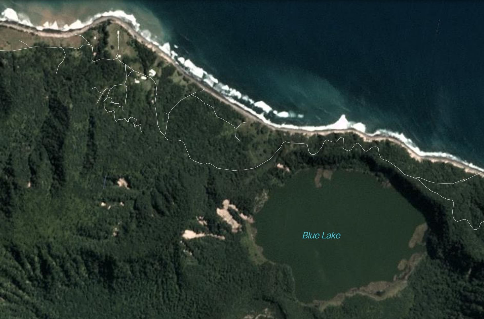
Coseismic landslides on Raoul Island. Image copyright Planet Labs, used with permission.
.
The Geonet report includes some photographs of the landslides seen in the Planet Labs image:-
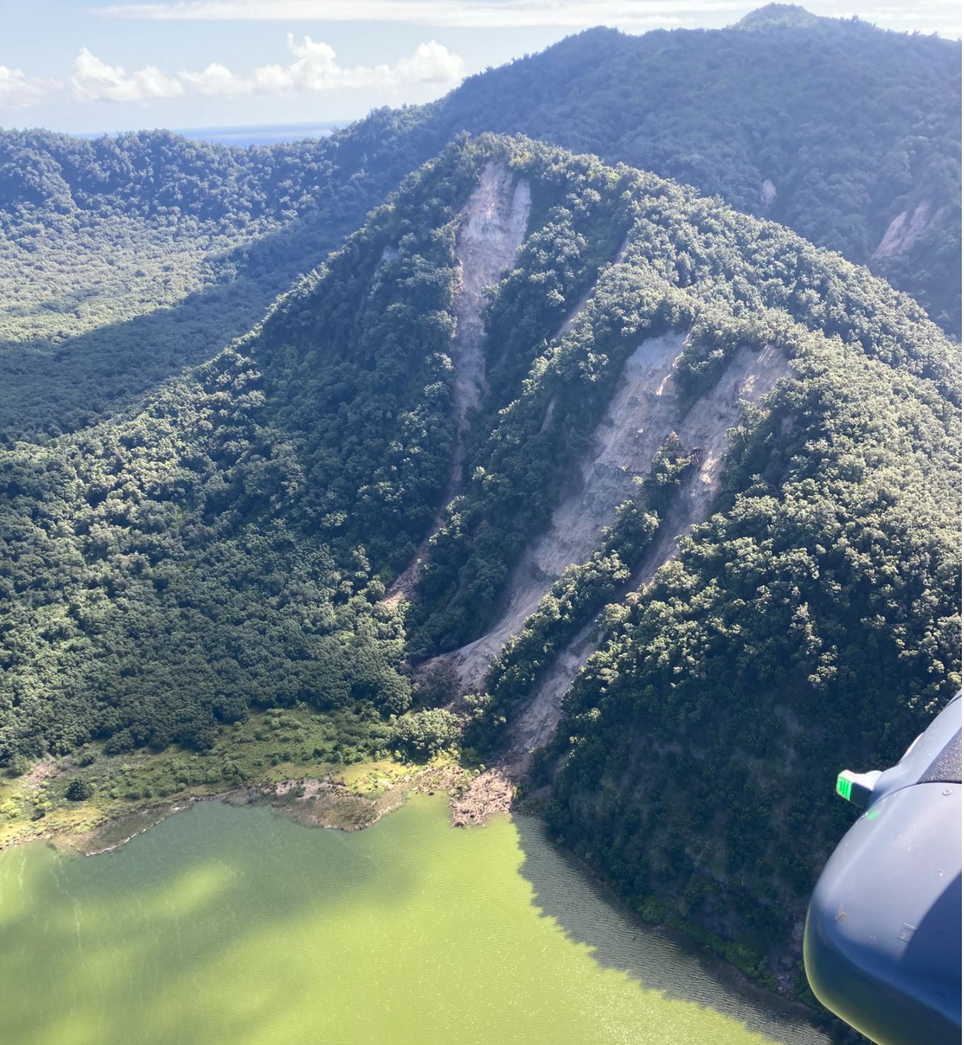
Landslides on the edge of Blue Lake on Raoul Island. Image from GNS Science / Geonet.
.
The research team have made the following observations about the landslides:
The most spectacular landslides were around Blue Lake, and along the rugged coastline. There was a significant slip at Bells Beach, where about 400 m of coastal cliffs collapsed, leaving a plume of sediment in the ocean. Most of the landslides were relatively small (100-200 m³) rock and soil avalanches and falls, but there were some larger ones up to about 20,000 m³. The largest landslides were on the north-east coast near Hutchison Bluff, and around the crater of Blue Lake, most landslides comprised rock and soil avalanches and falls.
Reference
Planet Team (2021). Planet Application Program Interface: In Space for Life on Earth. San Francisco, CA. https://www.planet.com/
25 March 2021
Wongawallan: a damaging landslide in Australia
Wongawallan: a damaging landslide in Australia
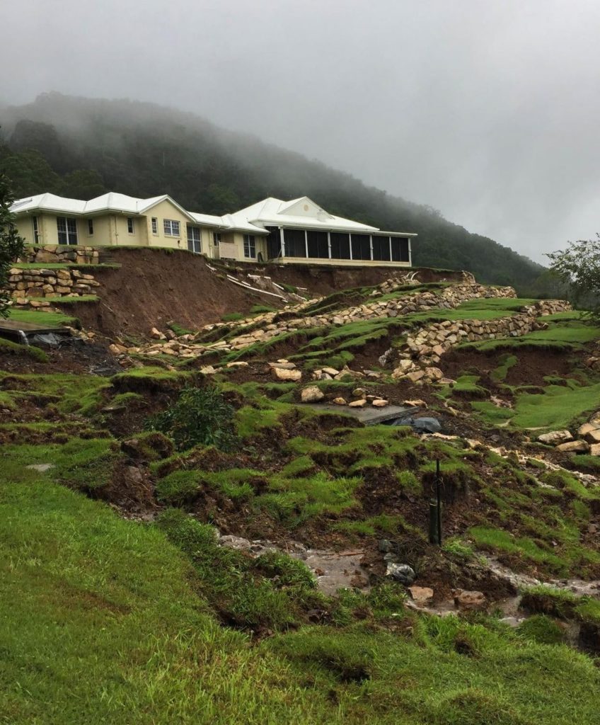
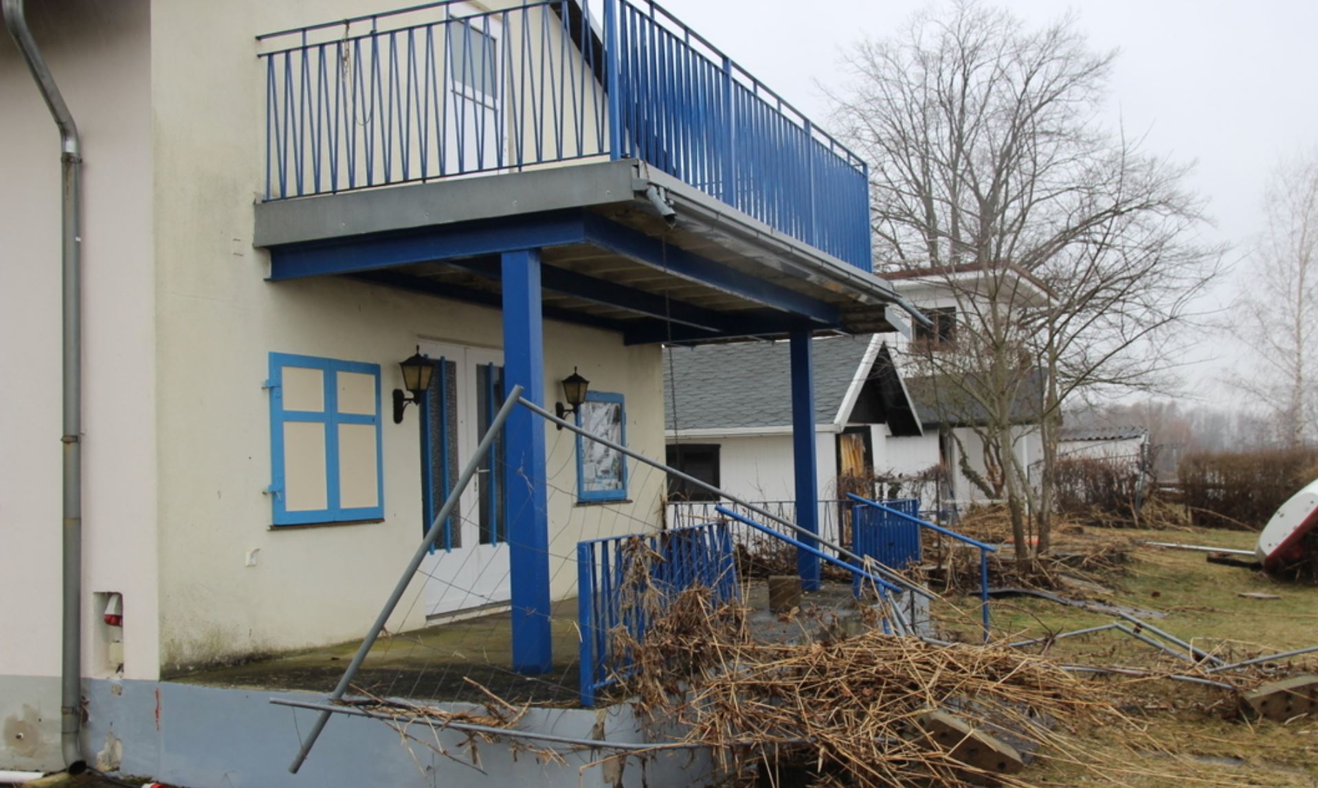
The eastern side of Australia has suffered devastating rains over the last few days, causing extensive flooding. There have been a number of landslides too, of which the most spectacular may be the one at Wongawallan in the Gold Coast hinterland in Queensland. This landslide appears to have affected the grounds of a very beautiful house. The image below, from Reddit, shows the site before the landslide:-

The site of the Wongawallan landslide. Image via Reddit.
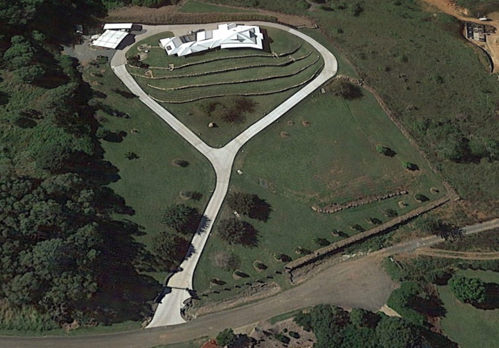
The image below shows the aftermath of the landslide, again the image is from Reddit:
The aftermath of the Wongawallan landslide in Australia. Image via Reddit.
.
Clearly for the homeowner this is a disastrous landslide, causing enormous levels of damage. Looking at Google Earth, it appears that the property was constructed between 2004 and 2009. The mound upon which it is located appears to be made ground, initially without the terraces, which appear to have been under construction is an image in November 2013. I wonder why the slope was terraced at this later stage? The Google Earth images might provide a clue, but I do not wish to speculate. The location of the landslide is -27.880° 153.245°.
The image below shows the state of the terraced slope, and the adjacent slopes, in 2016:-
Google Earth image of the site of the Wongawallan landslide in Australia.
.
The obvious part of the failure is the section of terraced slope directly below the house, but the landslide appears to have extended all the way down to the gates, a distance of about 110 metres:-
The lower part of the slope failure at Wongawallan. Image via 9 News.
.
There are two obvious possible failure mechanisms here. It could be that the terraced mound has failed, loading the lower part of the slope, inducing failure lower down. An alternative is that the ground beneath the mound has failed, with the instability retrogressing though the mound. A proper site investigation is needed to ascertain the cause.
The impacts are unfortunately likely to be extremely expensive, and to be very disruptive for the owners of a beautiful property.
22 March 2021
The preferred route corridor for the A83 at Rest and Be Thankful
The preferred route corridor for the A83 at Rest and Be Thankful
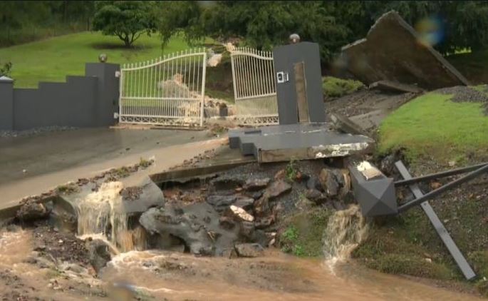
In terms of disruption and economic cost, the most serious landslide problem in the UK at the moment is the alignment of the A83 at Rest and Be Thankful in Scotland. This key road, which provides access to an important area of Argyll and Bute, has suffered repeated landslide problems over more than a decade. There is strong evidence that these problems are becoming worse with time.
Work has been underway to identify a route that avoids this problematic stretch of the landscape in Glen Croe. In a rugged, protected landscape there is no simple solution.
Late last week the Scottish Government announced their preferred option, which was based on the so-called Glen Croe Corridor Option 1. Transport Scotland has now provided a really excellent Story Map that provides details of the options in play and the detailed processes used to assess their viability. This proposal will retain the alignment within Glen Croe, but there is then a range of possible alignments within the valley:-
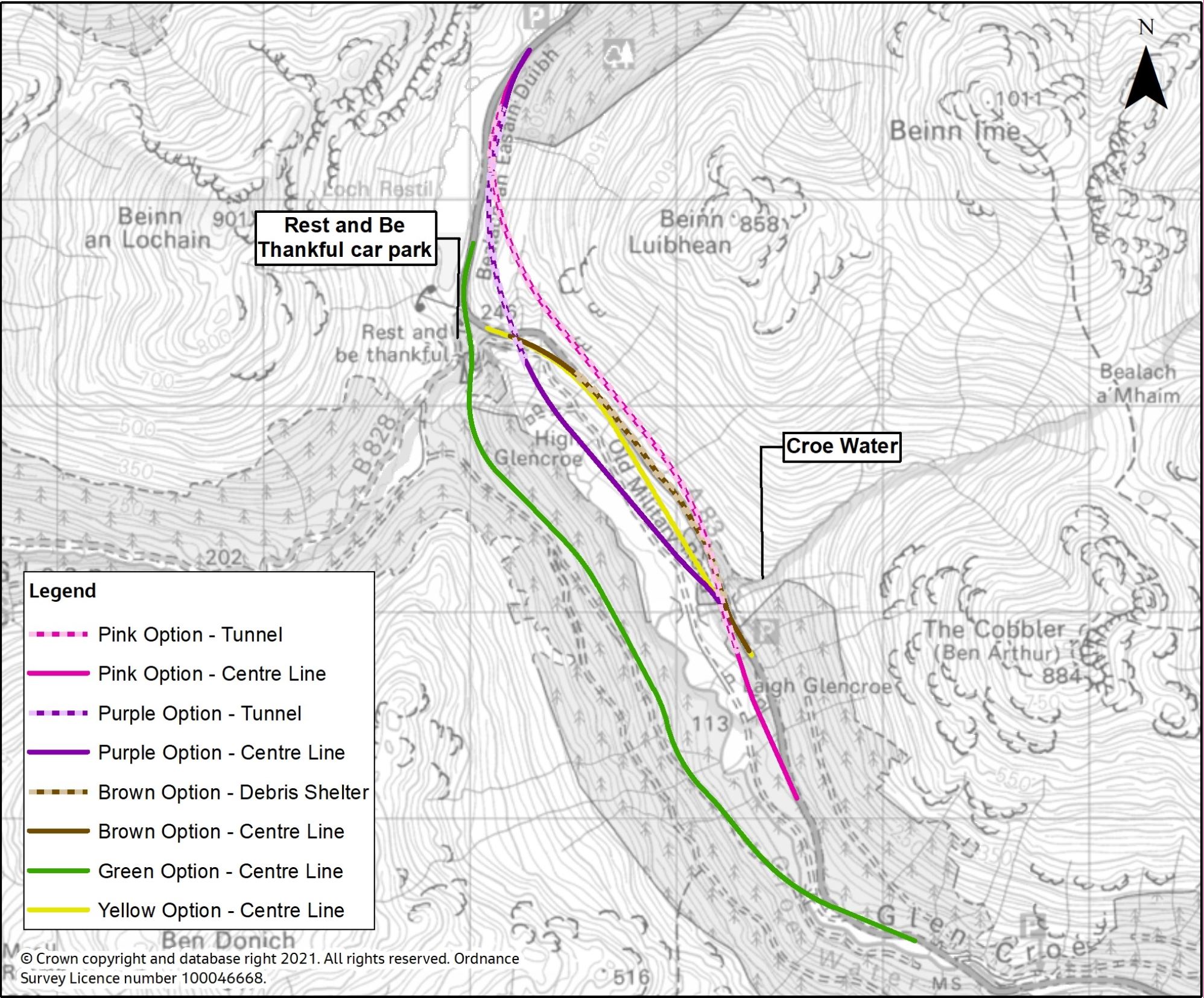
The potential alignment options for the A83 at Rest and Be Thankful.
.
A part of the problematic slope at Rest and Be Thankful.
The options are:
The brown option closely follows the alignment of the current A83 Trunk Road and includes construction of a debris flow shelter around 1.3 km in length over the existing road, as well as a length of viaduct of approximately 0.3 km to improve road alignment on the approach to the Rest and Be Thankful car park.
The yellow option would see a new single carriageway road constructed approximately 2.1km in length, positioned between the existing A83 Trunk Road and Old Military Road. This would include a length of new carriageway on a viaduct around 1.8 km long from Croe Water to the Rest and Be Thankful car park.
The green option would involve the construction of a new single carriageway road around 4.3 km long on the opposite side of the valley from the current A83 Trunk Road, crossing the valley floor and Croe Water over a viaduct 0.2 km in length. Landslide mitigation works such as debris flow shelters, fencing and viaducts, would also likely be required to protect the proposed road from future landslide events.
The purple option provides a new length of single carriageway around 3.2 km in length, positioned within the Glen Croe valley floor and tying into the existing A83 Trunk Road south of the Croe Water.
The pink option would involve construction of a new length of single carriageway approximately 4.1km long, of which around 2.9 km would be within a tunnel. The tunnel would pass under the Croe Water and the A83 Trunk Road.
Transport Scotland is inviting views on these options, whilst starting the process of assessing in detail their viability. A Strategic Environmental Assessment (SEA) Environmental Report will be published next month.
In the meantime works continue to try to protect the existing alignment – completing the new road will take several years at best. I hope to pay another visit once the current ban on travel in the UK comes to an end.
19 March 2021
Tbilisi: a 500,000 cubic metre landslide, probably triggered by road construction
Tbilisi: a 500,000 cubic metre landslide, probabkly triggered by road construction
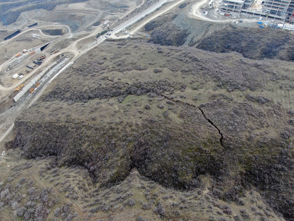
In Tblisi in Georgia, a 500,000 cubic metre landslide has developed on the edge of the metropolitan area, probably triggered by construction of a road. The landslide which is described in articles in both Vestnikkavkaza.net and JAM News, is impressive in scale:-
The landslide in Tblisi. Image from JAM.net, originally posted to Forum.ge
.
The image above shows a very large fissure that defines the mobile block. This appears to be sliding towards the left of the image, where the slope has been cut fro road construction. The image below provides a sense of the motion:
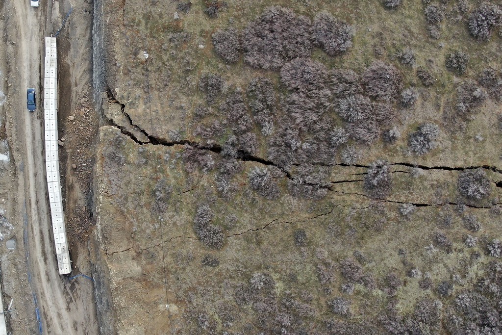
The sense of movement of the landslide in Tblisi. Image via JAM.net via Forum.ge
.
The under-excavation road is being protected from minor rockfalls by a barrier of what appears to be concrete blocks. This suggests that the movement has been developing for a few days at least.
The landslide has developed on the margins of a new road linking two residential areas of Tbilisi – Vashlijvri and Nutsubidze. I believe that the Google Earth image below shows the site. This image was taken in July 2020:-
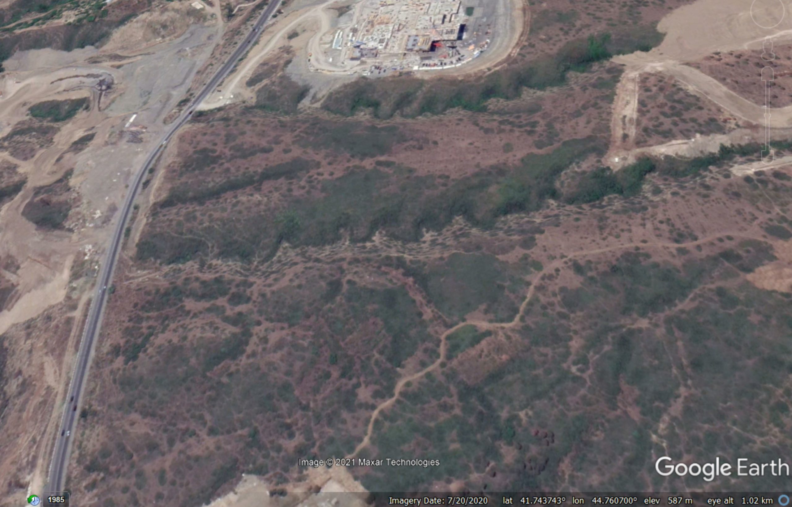
Google Earth image of the site of the landslide in Tblisi
.
The JAM.net article provides some insights from local experts:
“The earth may descend tomorrow, the day after tomorrow, or in a year, but it will definitely come down. Where and how – the issue of modeling, it needs to be assessed,” said Geologist Tea Godoladze, director of the National Center for Seismological Monitoring.
According to her, geologists and surveyors who have already made the initial assessment have come to the conclusion that cracks in the slope are the result of improper intervention in the environment. And, most likely, a landslide cannot be avoided.
The danger exists both in the immediate vicinity of the landslide and in other areas, since the support system is also broken there, said geomorphologist Lasha Sukhishvili.
“The speed of the landslide is still unclear. This can take years. But, for example, due to heavy rain or some vibrations, the process may speed up a little,” said Sukhishvili.
Managing a landslide of this scale will be challenging. I am reminded of the Rattlesnake Ridge landslide, where the pragmatic solution has been simply to allow it to move whilst monitoring it carefully.
18 March 2021
Retrogressive breach failures
Retrogressive breach failures
Earlier this week I posted a piece about the remarkable failure at Knappensee in eastern Germany, which was caught on video. The failure, on the banks of a flooded open cast coal mine, was retrogressive, generating a substantial displacement wave. Loyal reader Konrad Beinssen from Australia posted a description of this type of failure, which is termed a “retrogressive breach failure”. As I wasn’t aware of this particular failure type, I thought I would post his comment here.
This type of soil failure now known as a ‘retrogressive breach failure’ is not uncommon in coastal, river and lake settings, worldwide. Notable locations are the lower Mississippi, Inskip and Amity Points in Eastern Australia and in the sandy estuaries of the Netherlands.
A small triggering event in submerged (saturated) sand starts the process of ‘breaching’, well known to operators in the dredging industry. A near vertical wall of sand (the breach) migrates upslope. This wall is temporally stabilised by dilation of the sand skeleton immediately behind the breach causing suction (strain hardening). Granular material (such as sand) is shed from the breach as it migrates upslope and this generates a density current which transports grains offshore before they loose momentum and settle to the bottom.
As the breach arrives at the shore and migrates further inland, it undermines material above the water table, which topples in and adds further to the density (turbidity) current.
Konrad points us to a paper (Mastbergen et al. 2019), which is open access, which describes this failure mechanism in more detail. It includes this explanatory diagram:
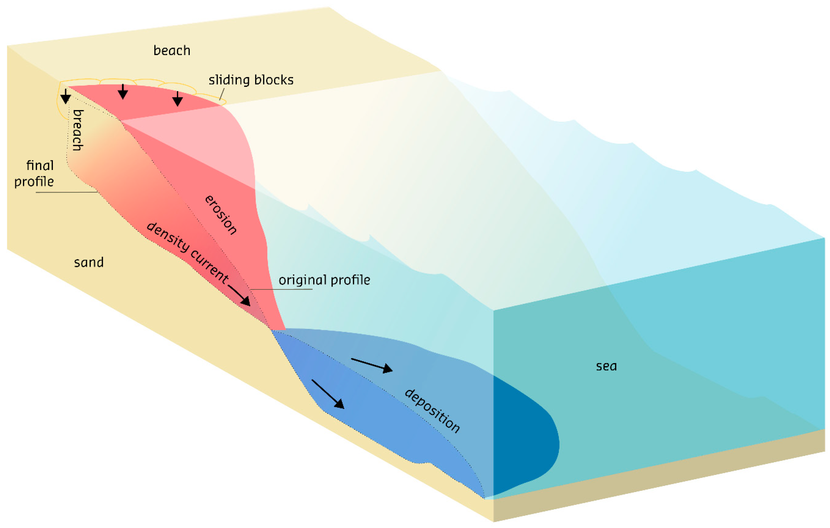
A schematic diagram of the retogressive breach failure concept. From Mastbergen et al. (2019).
.
The paper includes a number of other examples of these types of failure. It includes the Inskip landslide in Australia, which I also featured on this blog.
.
Reference
Mastbergen, D.R.; Beinssen, K.; Nédélec, Y. 2019. “Watching the Beach Steadily Disappearing: The Evolution of Understanding of Retrogressive Breach Failures” Journal of Marine Science and Engineering, 7 (10):368. https://doi.org/10.3390/jmse7100368.
15 March 2021
Knappensee: a large landslide at an old open cast mining site in eastern Germany
Knappensee: a large landslide at an old open cast mining site in eastern Germany
On Thursday 11 March 2021 a large landslide occurred on the banks of an abandoned and flooded open case coal mine site at Knappensee in eastern Germany. The images after the event are impressive:-
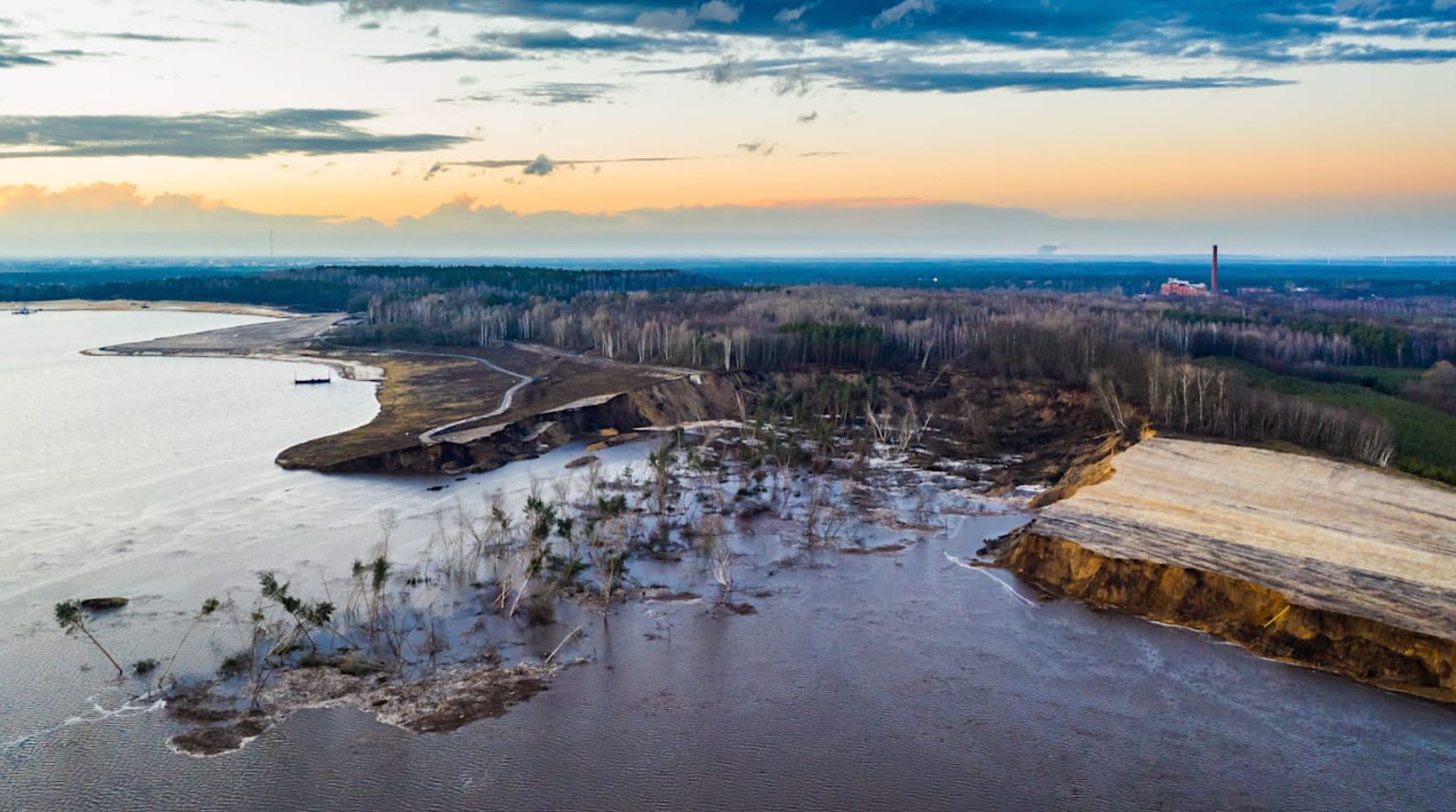
The aftermath of the landslide at Knappensee on 11 March 2021. Image by HY-photo Gernot Menzel via Bild.
.
The event was captured on a remarkable video that has been posted to Youtube. This video starts with an orientation problem that is soon resolved:-
.
Judging by news reports, the banks of the Knappensee have been undergoing remediation to allow the site to become a recreation attraction. This bank had been undergoing work recently – I note the various vessels in the video – and was a site with known geotechnical problems. The unslipped areas in the image above have little or no vegetation, suggesting engineering works since the last growing season.
The landslide at Knappensee was probably triggered by renovation work in the bank area. Experts from the Saxon Mining Authority have come to this conclusion. In the past few weeks, the first careful security measures have been carried out in this area. Among other things, dump material has been removed and work has been prepared in the bank area, said the Mining Authority. This was also the case on the day of the landslide, which is why this work is suspected to be the trigger.
The landslide appears to have been retrogressive, starting with a small failure at the toe. That in turn may have been triggered by a slip under the water, but that is speculation at this point. The final scar is reported to be 500 m by 200 m.
The landslide generated a displacement wave – reported to be about 1.5 metres high. Whilst this would be small in a marine environment, in a non-tidal lake this is significant event. This tsunami damaged properties on the other side of the lake:-
Damage caused by the displacement wave at Knappensee in Germany. Image by Torsten Richter-Zippack via LR Online.
.
The level of the lake has been raised by 32 cm as a result of the landslide. This is now being lowered, but slowly because of the fear that rapid drawdown will trigger further instability.
Large failures in open cast coal mines, or in coal mine waste piles, are not rare, Recent examples include:-
- The 2014 Mina Pecket landslide in Chile
- The 2013 Hatfield Colliery landslide in the UK
- The 2017 Kakanj landslide in Bosnia
12 March 2021
The stability of mine waste tailings facilities
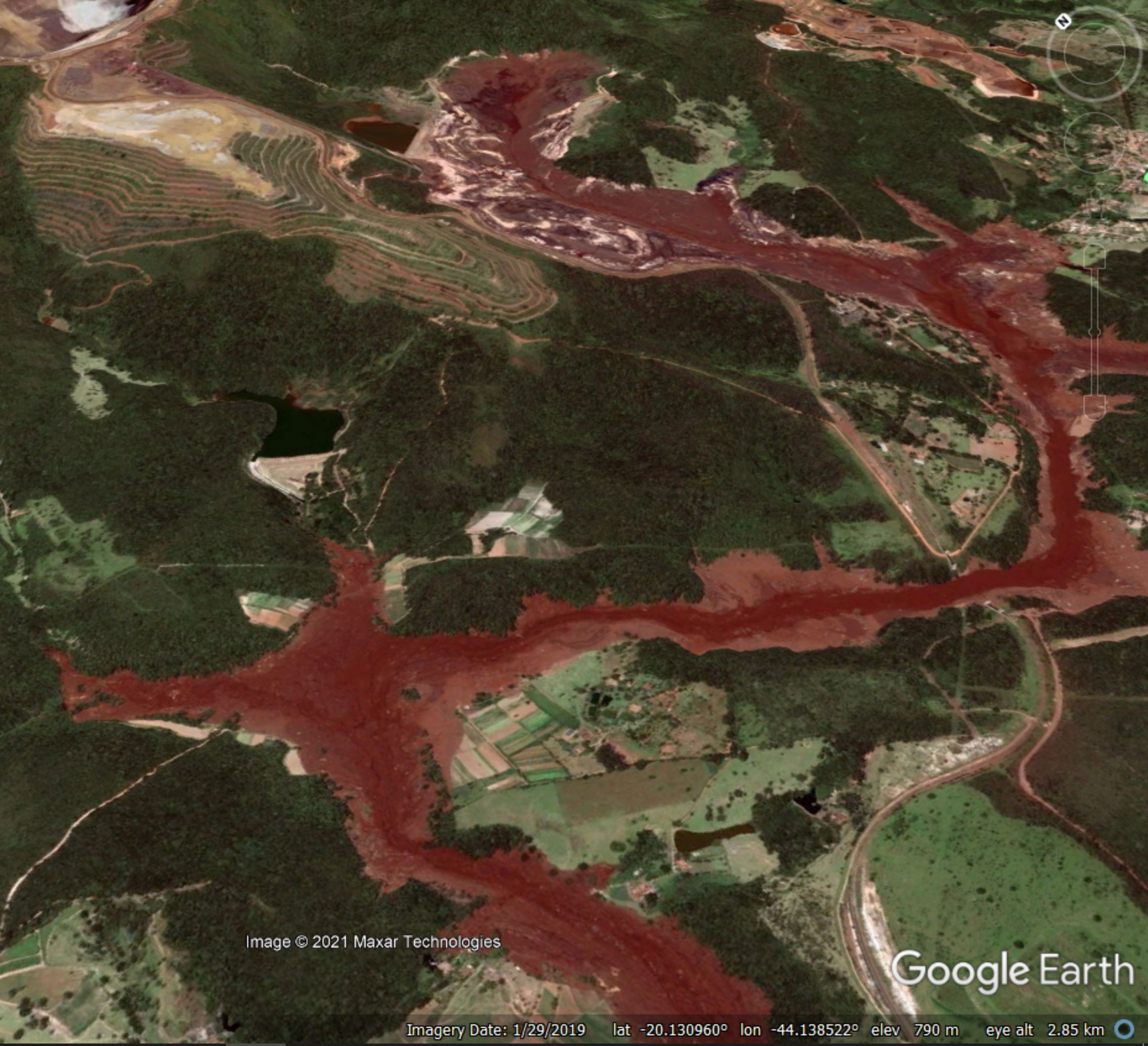
The aftermath of the Brumadinho tailings failure in Brazil. Image via Google Earth.
The stability of mine waste tailings facilities
In recent years there has been a sequence of major failures in mine waste tailings facilities, involving loss of life, severe economic damage and environmental catastrophe. As global mining continues to expand there are major concerns about the likelihood of further major failure events, although the industry would maintain that there are serious efforts ongoing to improve tailings management.
A really interesting paper has just been published in the journal Scientific Reports (Franks et al. 2021), which is available open access, which reports upon a database of tailings facilities worldwide. This database has been compiled through requests for disclosures from mining companies. They requested information on tailings facilities from 726 publicly-listed extraction companies. In total, 107 companies responded. The authors recognise that this has limitations, but the results are still eye-opening.
Franks et al. (2021) included in their request for information the following:
Companies were requested to disclose any situation where a facility, “at any point in its history, failed to be confirmed or certified as stable, or experienced notable stability concerns, as identified by an independent engineer (even if later certified as stable by the same or a different firm).”
In total, 10% of all tailings facilities were reported to have suffered a stability issue, but as the image below shows, this was much higher for the (much more risky) upstream type of tailings dam:-
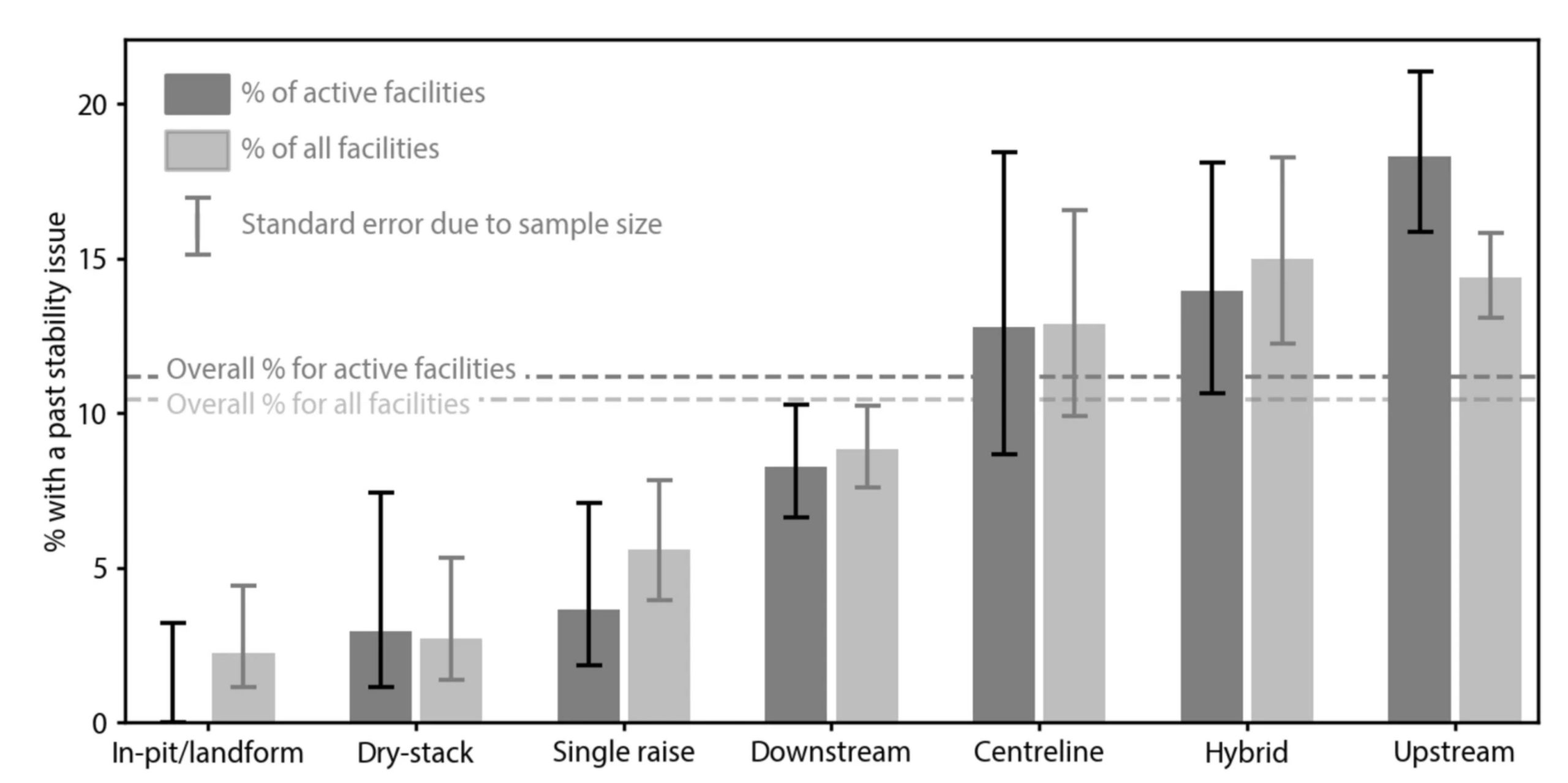
Stability of tailings facilities. Proportion of facilities with a stability issue by raise type. Error bar lengths are binomial confidence intervals for the subsample represented by each bar, showing ± 1 standard error (approximately 68%). Figure from Franks et al. (2021).
.
The hazards associated with the upstream method are clear to see. Given the potential impacts of the failure of a tailings dam, the figures in this graph are alarming.
It is also notable that the authors found that:
A significant number of facilities (501; 29%) have not formally considered the downstream effects of a hypothetical catastrophic failure
This is a remarkable finding.
The authors note that their database accounts for only about 30% of global commodity production. I think one can hypothesise that the companies that have made a disclosure are more likely to be managing their facilities properly. If so, the global picture is probably even worse than the figure above suggests.
I cannot sum up the implications of this piece of work better than Franks et al. (2021) themselves:
The sheer scale of global tailings production and the high impact of tailings facility failures highlights the need to improve all aspects of tailings disposal and management. Furthermore, the data highlight the need to continue developing management options and technologies to both minimize tailings production and to repurpose tailings to reduce storage requirements and their associated risks. In the short term, the data suggest that ever larger tailings storage facilities will continue to be built in locations with ever higher consequences of failure. Greater transparency brought about by these and future disclosures could play an important role in the reduction, and ideally elimination, of catastrophic tailings facility failures.
This paper is a good start, and a very valuable contribution, but the industry has a long way to go.
Reference
Franks, D.M., Stringer, M., Torres-Cruz, L.A. et al. 2021 Tailings facility disclosures reveal stability risks. Scientific Reports 11, 5353 (2021). https://doi.org/10.1038/s41598-021-84897-0.
 Dave Petley is the Vice-Chancellor of the University of Hull in the United Kingdom. His blog provides commentary and analysis of landslide events occurring worldwide, including the landslides themselves, latest research, and conferences and meetings.
Recent Comments