
5 May 2015
The Langtang ice and rock avalanche in the Gorkha Earthquake
The Langtang ice and rock avalanche
Over the weekend the picture is slowly becoming clearer in terms of landslides associated with the Gorkha Earthquake in Nepal. It is now apparent that the level of landsliding in the Hill Districts at least is rather lower than we might have feared, although it is still far from insignificant. Understanding the situation in the higher mountains remains very challenging due to the amount of cloud cover that is still preventing satellite images from being available. We have to hope that a window opens up before the monsoon.
So far the stand our landslide event appears to be the ice and rock avalanche at Langtang. This appears to have caused substantial loss of life. Not for the faint-hearted, this BBC report from the scene leaves little to the imagination in terms of the likely losses.
.
.
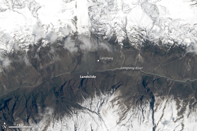
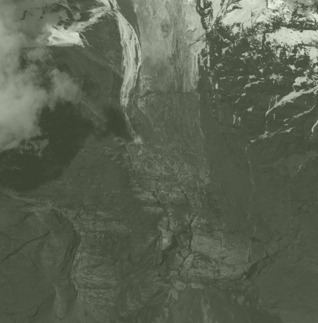
NASA have managed to collect some imagery of the site. This is a post-event Landsat 8 image that clearly shows the avalanche:
.
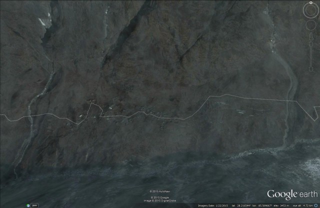
This is the Google Earth image of the village of Langtang before the ice and rock avalanche:
Google Earth
.
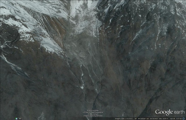
The Digital Globe satellite imagery of the site captures the avalanche track and deposit pretty well:
.
This is a slightly odd event because of the lack of a clear large deposit. My initial (and very provisonal) interpretation would be that a chunk of ice and rock broke off from the slope above the village – a comparison of the Google Earth image from January with the Digital Globe image suggests this strongly:
Before:-
Google Earth
After:
.
I suspect that this mass then went through freefall / rapid sliding into the valley below (removing rock from the surface en route – the planed off surface is clearly apparent in the image above). Google Earth suggests that the fall was about 700 or 800 m vertical distance – and that the mass then fragmented on impact to create a massive blast of air, ice and rock. This is similar to the Seti River rock avalanche that I featured three years ago, although on a smaller scale. This mechanism would account for the huge damage that occurred in Langtang.
2 May 2015
Gorkha Earthquake – the slowly emerging landslide picture
Gorkha Earthquake
The official name for the earthquake in Nepal a week ago is now the Gorkha Earthquake. The casualty count slowly continues to rise – 6659 fatalities at the latest count, but this is likely to rise significantly in the coming days. We are slowly getting a better understanding of the earthquake and its impacts, although the picture in the rural districts remains worryingly unclear. My sense is that we are now starting to get information about rural settlements on the major highways, but the situation in the many communities away from the main roads (which is the vast majority) remains unclear.
Concentrating on landslides, which is the focus of this blog, I thought I’d pull together some snippets of information that are now available. This is far from comprehensive though.
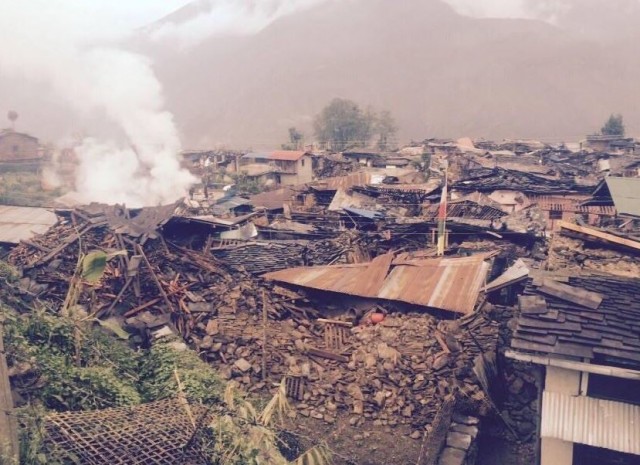
1. The dreadful damage in the Langtang region
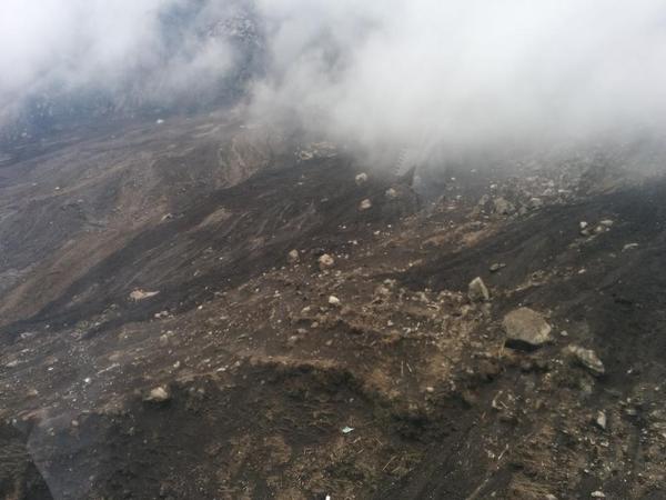
There have been various reports of the impact of landslides in the Langtang region, a popular trekking area, and I wrote about this earlier in the week. Whilst the situation is desperately confused, it appears that there may have been two large rock/ice avalanches, one affecting Langtang itself and the other, a few days later, destroying Ghotabela. Himali Sherpa has posted some images of the destruction in Langtang via Facebook:
.
It is hard to believe that these will be many survivors from this. It appears that this may have been a rock/ice avalanche, but information is still scarce.
2. ICIMOD analysis of valley blocking landslides
Meanwhile ICIMOD have been leading the analysis of satellite imagery of potential valley-blocking landslides. They have identified a number of large slides, although fortunately to date these do not seem on first inspection to be too problematic. Note though that very large areas remain cloud-covered so we are not out of the woods as yet. The largest to date is in a remote area in the mountains:
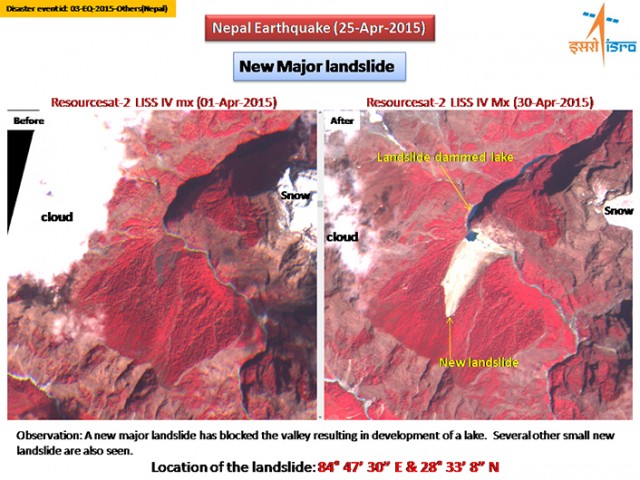
ICIMOD analysis of seismically-induced landslides
.
3. Landslides on the Arniko Highway
Meanwhile, Kantipur today has an interesting article about efforts to clear the Arniko (sometimes called Araniko) Highway, which is the road that links Kathmandu to Tibet – a vital trade route. It includes this image of landslide damage:
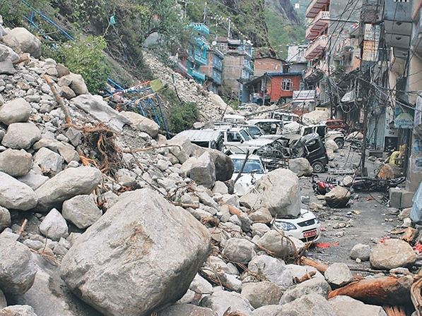
.
The reports states that:
It is suspected that scores of people, including some foreigners, visiting Tatopani and around 25 vehicles were buried in landslides triggered by Saturday’s massive earthquake. According to witnesses, scores of people were buried at Miteripul, Chaku, Jhyalebhir, Nayapur, Daklang Paharo and Jhirpu. “Ten to fifteen people working at caterings and restaurants in Khasa were buried by landslide at Chaku,” said Shyam Shrestha, who witnessed the tragedy. Some buses, private vehicles and motorcycles were also buried in the area.
30 April 2015
Upper Bhote Kosi: videos of the damage and rockfalls in northern Nepal
Upper Bhote Kosi
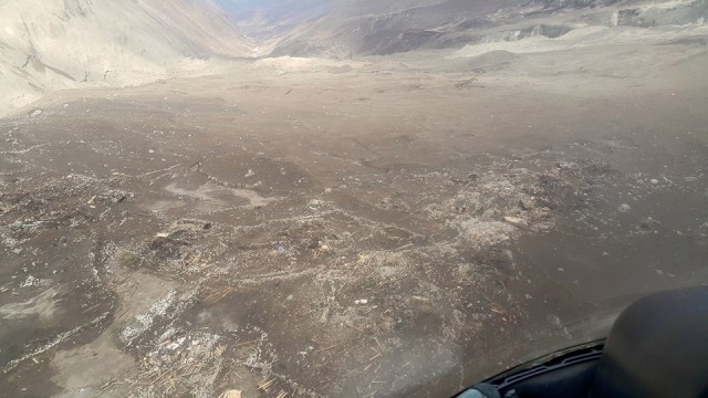
The Last Resort is a bungy jumping centre located in the Upper Bhote Kosi valley northeast of Kathmandu. This is to the north of the area affected by the massive landslide last summer. This is an area that I know well as we have used the resort as a field base for many years. Although there is still a great deal of uncertainty as to the nature of the impact of the earthquake in this area, it is reasonable to assume that the effects have been very severe.
Bhuwan Sharma was at the resort at the time of the earthquake, and has posted a series of videos on his youtube channel. I thought I’d highlight two of them here. First, this one shows rockfall activity in the Bhote Kosi gorge during what I assume is an aftershock:
.
Note the extensive rockfall activity both upstream and downstream of the bridge across the Bhote Kosi. If you look carefully you can also see the substantial piles of debris in the river channel from the earlier shocks:
 .
.
Whilst this video shows the damage in the surrounding villages in the Upper Bhote Kosi valley:
.
Clearly there is extensive destruction to the houses, some of which have collapsed. This suggests that the damage in the Upper Bhote Kosi valley is likely to be very serious. This is important because the reported losses for this earthquake, although terrible, continue to be lower than we would have expected and seem to be at odds with reports from other parts of the mountain area. Others are equally confused as to what is going on – indeed some models suggest that the losses should be an order of magnitude higher. It is very perplexing. Meanwhile, as usual the media seem to be fixated on individual rescues rather than on the big picture. Each of these “miracle” survival stories are wonderful, but to report them so assiduously is to miss the big picture in my view.
29 April 2015
Landslides in Langtang during and after the Nepal earthquake
Landslides in Langtang during and after the Nepal earthquake
The situation in the rural areas of Nepal after the earthquake is slowly, very slowly, becoming apparent. At the moment the clearest indications of serious problems are in Langtang – an area to north of Kathmandu that is popular with trekkers. A search on twitter using the term *langtang is chilling, with long lists of missing people:-

.
It is clear that landslides and avalanches have been a very significant factor in this area, both during the earthquake itself and in the aftermath. There is a very interesting account of this on the Facebook page of Robbie Barnett from Austin Lord, posted on the Modern Tibet Facebook page. I won’t repeat the whole post, but will highlight a couple of key sections:-
“The village of Langtang was the site of the largest single catastrophe, as the entirety of village was completely buried by an avalanche that came from thousands of feet above on the southern slopes of Langtang Lirung and Langtang II. Smaller settlements on the outskirts of Langtang, such as Chyamki, Thangsyap, and Mundu were also buried. It is impossible to determine exactly how many people died there, but the estimate is perhaps over 300 people in total. The handful of survivors, roughly twelve locals and two foreigners, walked down to Ghodatabela below after spending the night of the 25th in a cave – thus there is no one at Langtang itself. This avalanche is perhaps 2-3 kilometers wide, and is obstructing movement within the upper valley corridor. Currently two large groups are stranded above and below (due to several intensive and recurring landslides in the steep sections between Ghodatabela and Lama Hotel).”
“Below, at Ghodatabela (where I was located during the earthquake for roughly 55 hours following the event) several large landslides were triggered from all directions, the largest from perhaps 1,500 meters above just below the settlement, completely obstructing passage. The two guesthouses there were partially destroyed by large boulders, and the army checkpoint barracks collapsed during the earthquake. The night after the quake, there were two groups sleeping in separate fields by the river, keeping distance from ongoing landslides and rockfall that continued throughout the night.”
“Along the Trishuli River valley itself, there are other smaller landslides and reports of significant collapse at Mailung, Simle, and Archale. In Betrawati, Gerkhu, and Mhanegaun in bordering Nuwakot district several houses also collapsed, and there were casualties in all of these places.”
“The current data on total casualties following the earthquake here in Nepal is approaching 4,500. However, this is probably an underestimate considering that the estimate for the entire district of Rasuwa is 250, and there are at least 300 dead in the area around the village of Langtang alone. Across the board, it is still very difficult to determine exactly what has occurred in remote areas off the road system, as communication is down. Considered in terms of the percentage of total population, my sense is that Rasuwa has likely the third highest rate of fatality, behind Sindhupalchowk (at the epicenter of the major aftershock) and Dhading (closer to the center of the earthquake). Again, Langtang is probably one of the greatest single tragedies of this earthquake.”
“This is the latest news that I have as of 5pm on April 28th.”
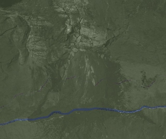
This is the Langtang valley in question:
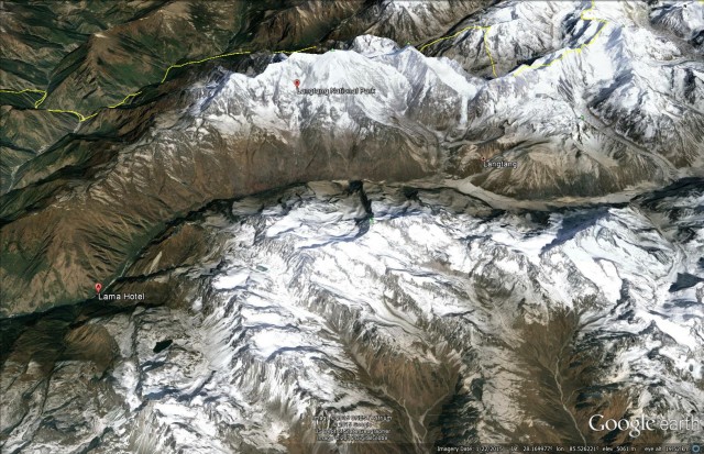
Google Earth
.
I assume that the landslide / avalanche at Langtang is the one that appeared in this tweeted image from early yesterday:
via Twitter
.
The Mountain Hydrology blog has a nice analysis of the potential source of this landslide.
And then yesterday came news of a post-seismic landslide or avalanche that struck the village of Ghodatabela, to which Austin Lord refers above. Information about this landslide is sketchy at present, but the Himalayan Times described it as follows:
“Not far from the quake’s epicenter, 250 people were feared missing after a mudslide and avalanche on Tuesday, district official Gautam Rimal said. Heavy snow had been falling near the village, Ghodatabela, and the ground may have been loosened by the quake. Rimal said officials received initial reports of the disaster by phone but then lost contact. The village, about a 12-hour walk from the nearest town, is along a popular trekking route, but it was not clear if the missing included trekkers.”
However, beyond this the picture remains worryingly unclear. These most recent events highlight the acute threat that landslides and avalanches will pose in the post-earthquake period, especially in the monsoon. There is an urgent need to start to systematically analyse the hazard. We hope that the EWF landslide guidelines will be a helpful first step
The village, about a 12-hour walk from the nearest town, is along a popular trekking route, but it was not clear if the missing included trekkers.
– See more at: http://www.thehimalayantimes.com/fullNews.php?headline=New%20mudslide%20hits%20Gorkha%20village%20near%20epicentre%20&NewsID=453075#sthash.ZHxlGRJQ.rYw0H6Jr.dpuf
Landslides in the Nepal earthquake: preliminary guidelines for relief and response activities
Pakistan 2005
Landslides in the Nepal earthquake: preliminary guidelines for relief and response activities
Alex Densmore, David Milledge, David Petley, Nick Rosser, and Katie Oven
Originally posted at the EWF Blog
The extent and effects of landsliding triggered by the 25 April 2015 Nepal earthquake remain unclear. However, since relief and response activities have already begun, and will accelerate in the coming days, we have assembled preliminary guidelines for relief and response workers and emergency planners in Nepal. They are informed by initial models of landslide likelihood, some fragmentary mapping of available satellite imagery, and experience in the 2005 Kashmir (Pakistan) and 2008 Wenchuan (China) earthquakes.
General pattern
Landslide susceptibility maps for the entire region have been posted at http://ewf.nerc.ac.uk/2015/04/25/nepal-earthquake-likely-areas-of-landsliding/ and https://blogs.agu.org/landslideblog/2015/04/26/nepal-earthquake-2/, along with some initial interpretations. These models are highly generalized and should not be used as predictions of the occurrence of individual landslides; instead, they give an idea of the areas where landslides are most likely. A brief summary interpretation of the key results:
- We expect many landslides in the high Himalaya of northern Nepal, where valley floor elevations exceed c. 800 m. These areas are particularly important because they have very long, steep slopes and narrow valleys, so that large landslides are likely to block valleys (see section on ‘Landslide dams’ below). The valleys of the Kali Gandaki, Marsyandi, Trisuli, and Sun Kosi rivers, and their major tributaries, are at greatest risk, but large valley-blocking landslides are also likely elsewhere. These areas also have little space for roads, so are likely to be cut off with overland access taking days (to weeks). Experience in Kashmir and Wenchuan suggests that some settlements will be completely disrupted or destroyed, with local death tolls in the hundreds to thousands.
- There is also a high chance of landsliding in the foothills – e.g., south of Kathmandu and the epicentral area, including the Siwalik Hills. These areas have shorter slopes (up to 1000 m relief) and broader valleys, so there is a lower chance of valley blocking. Preliminary reports are that roads across the Lesser Himalaya to the south of Kathmandu are open, but landslides and debris are hampering movements.
- Based on previous comparable EQs, it is highly likely that many relatively small landslides (1000s of m3 in volume), up to one if not more large valley-blocking landslide (> 1 million m3), will have occurred. Initial efforts should focus upon identifying the largest landslides, as they pose significant secondary risks if they dam rivers and subsequently fail (see ‘Landslide dams’ below).These models could be revised or run on more targeted areas if there is interest from stakeholders in specific areas, but they should NOT be used as predictions of landslide occurrence at particular sites. Our preliminary image mapping shows fewer landslides than the models anticipate, but imagery to date is patchy, with much cloud cover showing only the foothills. There is not yet any systematic information from the high Himalaya but mapping is ongoing. Experience in Wenchuan (China) shows that the earthquake will have weakened the hillslopes, so further landslides should be expected in the coming days to months – especially, but not only, during rainfall and aftershocks of M > 5. The locations affected by these post-earthquake landslides will be similar to those already affected most severely by the landslides. Wet landslides can be very rapid, and unpredictable in direction and runout.
Landslide dams
Most landslide dams fail within a few days of filling; thus, it is critical to establish where they are located and how rapidly they are filling. Periodic measurements of water level relative to dam crest are invaluable. In the absence of information to the contrary, it should be assumed that landslide dams have formed in all of the major river valleys or tributaries draining the area between the epicentre and Kathmandu. Key observations that a dam has formed upstream include: decreased river flow independent of any changes in rainfall, or changes in colour – especially a muddier-than-usual appearance. Flow gauges in Nepal, if still serviceable, should be monitored for rapid changes in flow on all rivers : http://hydrology.gov.np/
The effects of a landslide dam failure depend on the height of the dam and the volume of the lake behind it. As a general rule, valley floors and river channels should be avoided until it has been confirmed that no possible cause for flooding (via failed landslide or hydroelectric dams) exist upstream. Any temporary infrastructure in the valley floor should be sited as high as possible and as far as possible from the channel; a minimum elevation of AT LEAST 10 m above the active channel is recommended. Risk should also be minimised by positioning a spotter at the landslide dam with a comms link to all VDCs downstream and a clear protocol for communities to move to higher ground if there is a dam failure.
Operational guidance
Temporary infrastructure (temporary housing, hospitals, roads, etc.) should be sited to avoid further landslide hazards, flooding from potential landslide dams, inevitable increased river flow in the monsoon, and (over a period of weeks to months) river bed deposition from landslide sediment. Some general guidelines include:
- Site infrastructure in the widest possible part of the valley
- Avoid piles of large boulders or other signs of previous landsliding
- Stay at least 10 m above the active river channel, and as high as is practicable
- Stay away from steep hillslopes. Try to minimise the angle between a site and the local skyline. This angle should be <20 degrees if possible, although this may not be practical in many valleys
- If (re)cutting roads for access, minimise gradients, the number of switchbacks, and traverses across loose ground. Cut slopes that are just stable in dry conditions will be unstable in the monsoon.
Exposure
If further landslides occur, it is important that exposed field workers are briefed on what to do:
- In broad terms, follow the guidance for earthquakes. If you sense something happening or moving, ‘duck, cover, hold’, and importantly don’t run.
- Be aware of your surroundings. Unusual noises, tremors, or dust are all possible indicators of an earthquake OR a landslide. Landslides are surprisingly loud, especially in mountain valleys.
- A key component of risk is exposure, so minimising the time spent in areas that are apparently dangerous and susceptible to landsliding is essential.
- Landslides on steep hillslopes are often the source of more landslides over time. Don’t assume that because something has already failed, it will not continue to do so in the coming hours and days.
- Local communities will have a sound knowledge of where landslides have occurred prior to the earthquake. This information is invaluable and should be used wherever possible, as these slopes may be most susceptible. At the same time, be aware that the earthquake may have changed the landscape dramatically, so that other areas may also be at risk.
- Very generally, earthquakes trigger landslides on ridges, sending debris downslope. Many roads in the Himalaya follow the valley floors. It is therefore important to be aware of the terrain above, and the condition that it is in, even if you cannot see it. While shaking may be more violent on ridges, the chance of being struck by falling objects in valleys is much greater. When in doubt, move up, as ridges will be the safest parts of the landscape.
- Landslides can occur with no apparent trigger. Even if there is no rainfall or no further earthquake, a slope can still collapse. Keep away from steep slopes wherever possible.
- Mountain streams (large and small) will be choked with loose sediment and probably subject to debris flows, particularly in the monsoon. As a result, flows will be less predictable and more prone to flooding, even after moderate rainfall. Streams are also likely to change course unpredictably. Stay well away from river beds.
Next steps
We are currently compiling optical and radar satellite imagery to map large landslides and potential landslide dams across the affected area. We will update these guidelines as those maps become available.
Reference:
Alex Densmore, David Milledge, David Petley, Nick Rosser, and Katie Oven. 2015. Landslides in the Nepal earthquake: preliminary guidelines for relief and response activities. EWF Blog: http://ewf.nerc.ac.uk/2015/04/28/landslides-in-the-nepal-earthquake-preliminary-guidelines-for-relief-and-response-activities/
27 April 2015
Nepal earthquake impact – the key questions
Nepal Earthquake impact
Confusion continues to be a factor in determining the Nepal Earthquake impact – not unusual in any way, and not a criticism of anyone involved. The official death toll continues to increase – at the time of writing it is is 3351 (I strong recommend this twitter account for the latest information), and the total is rising quickly. But this remains much lower than we had anticipated for an event of this size in Nepal. This is partly because buildings in Kathmandu have performed far better than we had feared – at the moment the reasons for this are not clear, but it is very welcome.
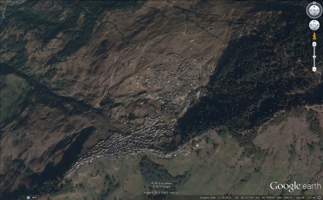
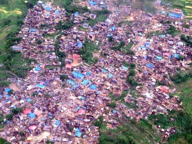
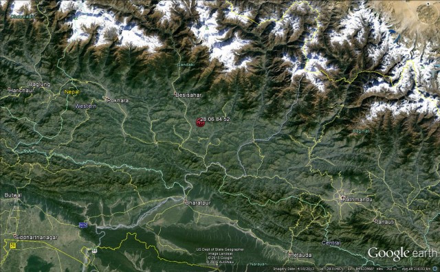
But the key question is what is happening to the north of Kathmandu in the rural areas. This is the zone in which the peak ground accelerations are likely to have been highest, and it is also an area in which the houses are vulnerable (typically being constructed of weak materials) and most communities live on, or close to, slopes. These communities, which are remote at the best of times, may well have been very badly affected by the earthquake. An example appears to be the town of Barpak, high in the mountains in Gorkha District. This is the Google Earth image of the town before the earthquake:
.
Various images have appeared of the aftermath of the earthquake in this town, all unfortunately unverified. But for example, this image has been widely retweeted:
.
 .
.
Both of these images suggest that losses in Barpak should be high. The key questions are:
1. To what degree are these losses included in the official totals (my guess would be they are not, but I might be wrong)?
2. To what degree is the damage in Barpak replicated elsewhere?
Because if the answer to 1. is that the official death toll does not account for the losses in Barpak, and to 2. is that this is replicated elsewhere then the losses are going to be much higher than at present. We can only hope that this is not the case.
Either way the pictures above suggest that a massive mobilisation of aid is going to be needed.
26 April 2015
Landslides from the Nepal earthquake yesterday
Landslides from the Nepal Earthquake
Whilst the Nepal Earthquake is now the centre of global attention, the true pattern of loss is not yet apparent. As usual, the focus in the first 24 hours is on the locations that have both media presence and easy telecommunications – in this case Kathmandu. The impacts there are undoubtedly serious, especially for historic masonry buildings, and the city will never be the same again. But the true impacts of this event are going to have been felt in the rural areas to the north of the city. At present there is little information from those districts, but expect the picture to be tragic as it emerges over the next two days.
Landslides are going to be a very real problem in those areas affected by the Nepal earthquake, and by its aftershocks. Indeed, just 15 minutes ago there was a very shallow M=6.8 aftershock that is likely to have caused substantial damage in its own right, albeit in a more limited area. There has been some confusion about the area affected by the earthquake, and in particular the area of most intense shaking. This is because there is a perception that the epicentre is the centre of the earthquake, and thus that the damage should radiate away from this point. This is not the case. The earthquake energy is derived from movement on a fault (or sometimes more than one fault) – a complex three-dimensional structure that extends over a large distance. The epicentre is just where the rupture initiates – i.e. the location at which the fault starts to move. The rupture then propagates along the fault, releasing energy as it goes. Often the rupture propagates quite evenly away from the epicentre, in which case the epicentre is close to the centre of the earthquake-affected area. But at other times the rupture propagates preferentially in one direction or another.
In the case of the Nepal Earthquake the rupture appears to have propagated mostly towards the east of the epicentre, not to the west. So the epicentre itself is at the west end of the earthquake affected zone. This is clear from the USGS shakemap, which shows the epicentre as a star:
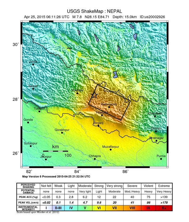 .
.
This was good for Pokhara, but bad for Kathmandu. It also explains why the impacts at Everest were so serious.
Possible landslides from the Nepal earthquake
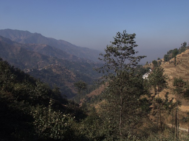
The most seriously affected area from the earthquake is mountainous and remote, but there are substantial numbers of people living in the valleys and on the hillsides. This is a typical landscape:-
 .
.
Further to the north the mountains become higher and the slopes longer. Note the terracing in the fields, the steep slopes and the large numbers of houses. There are many substantial villages, often located high on the slopes. This is highly landslide-prone territory, and the impact of the earthquake in these regions is going to be dreadful. Some effort is already being made to analyse the likely landslide effects, although at this stage such efforts are tentative. Over on the EWF blog, Alex Densmore has posted an initially analysis by Tom Robinson from the University of Canterbury of the likely areas affected by landslides:
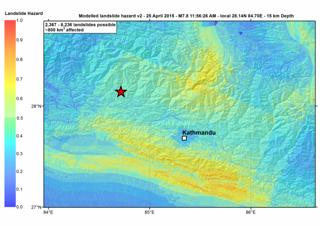
Landslide susceptibility in the Nepal Earthquake by Tom Robinson, University of Canterbury
.
There are a few things to note here. First, the analysis is dependent on the data quality, and you can see that there are some issues there (this is why there appears to be straight line boundaries in landslide hazard in places) – that is an important caveat. But the analysis is really interesting and helpful. It shows that to the north of Kathmandu, the very remote areas are likely to have been severely affected by landslides – but as yet there is no information from up there of course. And interestingly the hills to the south of Kathmandu are also badly impacted by landslides triggered by the Nepal earthquake – indeed the landslide picture might be as bad there as to the north. This is significant for two reasons – first, there are lots of people living in this area; and second, the roads that link Kathmandu to the outside world have to cross these hills.
Tom has run a quick analysis of the main roads affected by these landslides – the impacts look to be very serious:
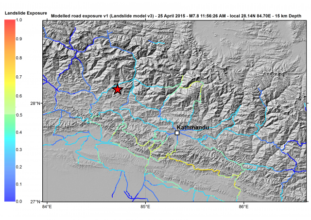
Likely major road impacts of landslides, by Tom Robinson, University of Canterbury
.
Kathmandu is entirely dependent on goods being brought into the city on these roads. If they are badly affected by landslides then the impacts will be severe.
There is a real urgency about the need to assess the actual landslide impacts, especially to the north – we need satellite imagery quickly. There must be a strong possibility of large valley-blocking landslides triggered by the Nepal Earthquake in the high mountains to the north- if so these will need to addressed without delay. The monsoon is going to be a real problem this year.
25 April 2015
The M=7.9 earthquake in Nepal this morning
The M=7.9 earthquake in Nepal this morning
NB updated to reflect the fact that this is now thought to be M=7.9 rather than M=7.6.
It appears that there was a large, shallow earthquake in Nepal this morning. The initial data suggests that this was a comparatively shallow event in the Central part of the country. Current data suggest:
M=7.5 at 11.9 km from the USGS
This will become clearer as the day wears on, but either way this is going to be serious. In terms of depth and magnitude this is generally comparable with the 2005 earthquake in Kashmir (updated: M=7.9 means that it is significantly larger), which killed over 70,000 in Pakistan and Nepal. Nepal has similar levels of vulnerability, but a lower capacity to cope (there is just a single runway at Kathmandu for example, and the armed forces are not well-equipped). The only thing that might help in this case is that the epicentral region does not contain a major city, but both Pokhara to the west and Kathmandu to the east are close enough to have been damaged. Kathmandu in particular is vulnerable, with poor quality buildings and soils that are prone to liquefaction, although in this case the distance should help. The Lamjung area itself is less densely population, which should reduce losses, but this is such a large earthquake that the effects will be severe.
This is the location as defined by the USGS:
.
So, we should expect extensive building damage with many thousands buried (there are already some images appearing on Twitter); serious damage to infrastructure, especially roads, telecommunications and electricity grids; and many landslides. This is likely to be a humanitarian crisis in the epicentral area, and with the monsoon just two months away the situation is going to be acute. The initial focus will be on Kathmandu, but the situation to the northwest of the city will be far worse. Expect to see little news from there for at least two days though.
Landslides are going to be a very serious problem. They will have caused losses; will have destroyed roads and other infrastructure, which will make the rescue and recovery operations very challenging; and they will continue to threaten the population. It is also likely that there are valley-blocking landslides in the mountains, which will be particularly problematic as the monsoon approaches. We need to find these very quickly.
20 April 2015
The Bolshaya Talda earthflow in Russia was a mine waste failure
The Bolshaya Talda earthflow
Many thanks to those who have helped to uncover the facts behind the amazing Bolshaya Talda earthflow in Russia, which was filmed in the amazing video about which I blogged late last week:
.
.
A couple of people emailed to suggest, and Brett Gilley noted in comments, that this might be a mine waste landslide, based on the materials involved, the appearance of the hills in the background and the presence of heavy equipment. In comments on the original post, Michal cracked it though:
Whilst it is difficult to be certain, the most likely location appears to me to be at about 54.144, 87.098. This site has all of the correct characteristics, including the appearance of the topography, the presence of the high voltage cables and the structure of the road:
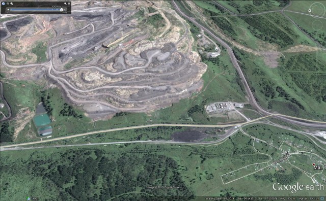
Google Earth
.
The image above is dated 8th September 2014. There is also an image from 9th September 2013 of the same site:
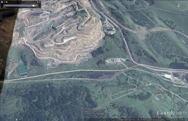
Google Earth
.
A comparison between the two images suggests that there has been recent active storage of waste at this site. The video suggests that it was this waste that collapsed to generate the landslide. It was fortunate that the failure occurred in the daytime and in an area with no houses. Of course, landslides like this should be avoidable – the mining industry is still associated with far too many landslides. Recent examples include:
- The Shawa landslide in China
- The Jiana/Gyama landslide in Tibet
- The Bingham Canyon landslide in Utah
- The Hatfield Colliery landslide in England
- The Collolar landslide in Turkey
- And of course the Aberfan landslide in Wales
And there are many more.
Thanks to everyone who helped to unpick the riddle of this landslide.
17 April 2015
New landslide video: a fascinating and huge Russian earthflow
There is an update to this post here
Russian Earthflow
An absolutely stunning new video has appeared on Youtube overnight showing footage shot from a road of the movement of a very large and very spectacular earthflow in Russia. It has to be said that the videographer was as cool as the weather in his or her slow retreat from the path of the landslide:-
.
.
There is no information about the landslide, except that it occurred on 1st April 2015 at Zarechnyi. Liveleak also has the video of the Russian earthflow, with a label that says Penzenskaya Oblast. If this is correct then it is in an area on the western side of Russia. Given that this would be the thawing season, the conditions would be right for this type of landslide. But there is also a volcano called Zarechnyi on Kamchatka, although I assume that this is not the location of this landslide.
Does anyone have any more information?
 Dave Petley is the Vice-Chancellor of the University of Hull in the United Kingdom. His blog provides commentary and analysis of landslide events occurring worldwide, including the landslides themselves, latest research, and conferences and meetings.