
12 November 2014
Mannen landslide: latest status report
Posted by Dave Petley
Mannen landslide
Over in Norway, the Mannen landslide continues to creep slowly – about 2 mm per day now, as the graph below shows:
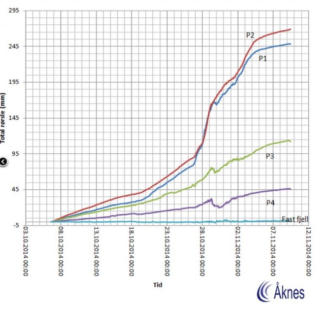
.
The Rauma Kommune website has an update (in Norwegian but Google Translate does a good job). The key points that emerge are:
- The risk level has been downgraded red to yellow, but this still requires continuous evaluation of monitoring data.;
- The monitoring system has been upgraded to provide better radar systems, the installation of a geophone (that might generate some very interesting scientific data), a LIDAR (laser) monitoring system and enhanced use of weather stations to determine the water inflow to the landslide;
- The railway has reopened to freight traffic only;
- Those evacuated from the site remain out of their houses;
- A decision has been taken (wisely in my view) not to use water-bombing due to the uncertainties
The latest update report from Aknes is also online (PDF again in Norwegian). The most interesting aspect of this report is a map showing the deformation across the hillside, with the monitoring positions marked as well. The map shows deformation over the period 6th to 29th October; I’d think this is slope radar data:
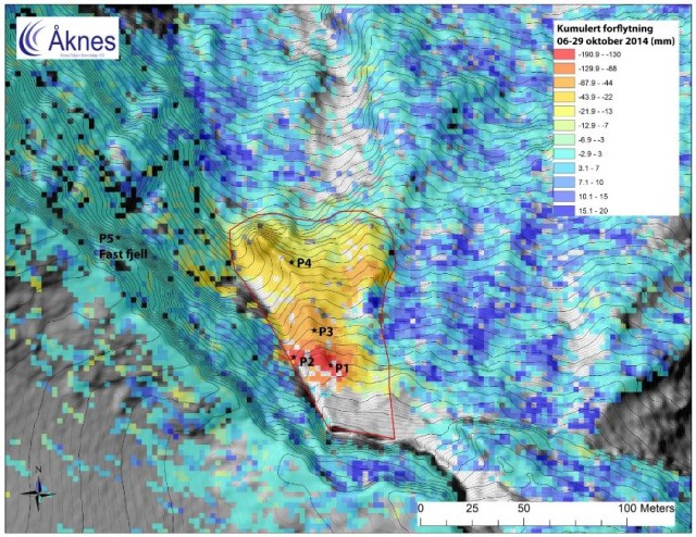
.
The very high level of deformation at the top of the slope is clearly visible, as are the smaller deformations downslope. This map helps gain an understanding of just what a large block makes up this active landslide. Given the onset of winter conditions the monitoring of the landslide and forecasting its future behaviour are becoming increasingly difficult. whilst the next obvious danger point will be the spring snow melt and thaw season, a period of warmer weather might also pose risks. Of course there is also a chance that the ongoing secondary creep will tip the landslide into a tertiary creep phase, leading to failure, so it is not possible to make any assumptions.
 Dave Petley is the Vice-Chancellor of the University of Hull in the United Kingdom. His blog provides commentary and analysis of landslide events occurring worldwide, including the landslides themselves, latest research, and conferences and meetings.