
3 October 2017
Murchison Hut: an interesting landslide problem in Aoraki/Mount Cook National Park
Posted by Dave Petley
Murchison Hut: an interesting landslide problem in Aoraki/Mount Cook National Park
The Murchison Hut is a climbers and skiers hut located on a slope above the Murchison Glacier in Aoraki/Mount Cook National Park in the South Island of New Zealand. An iconic location, it provides 10 bunks for those willing to experience the wilds of this beautiful national park:-
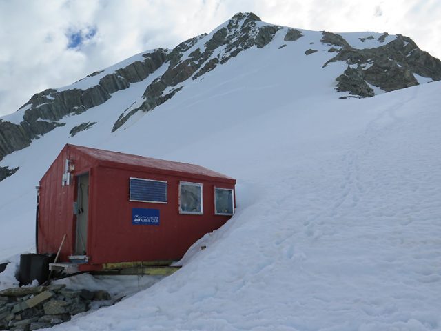
Murchison hut – image by Gary Dickson, Mountain Guide
.
The Alpine Club New Zealand web page for this hut indicates that it is “closed due to geological instability until further notice”. The New Zealand Herald posted a piece last week explaining the background to this decision. They noted that:
“Scientists have revealed the satellite images of mountain movement that have forced the closure of a climbers’ and skiers’ hut in Aoraki/Mount Cook National Park. Murchison Hut was closed last month over fears the mountainside it sits on could suddenly collapse into the glacier about 200m below, killing anyone inside the building. The urgent decision was made by hut manager the Department of Conservation and owner the New Zealand Alpine Club on advice from experts at Otago University and GNS Science.”
The work was undertaken by Dr Pascal Sirguey at the University of Otago and Dr Simon Cox from GNS Science, who compared aerial photographs of the site collected in November 2008 with aerial imagery from November 2015 and satellite imagery from February 2017. The image below plots the location of the hut on each of those occasions:-
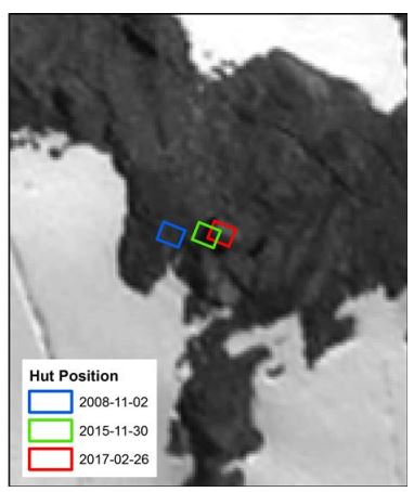
The location of the Murchison Hut over three epochs of imagery. Analysis by Dr Pascal Sirguey and Dr Simon Cox. Image credit: University of Otago/GNS/Pleiades Glacier Observatory/PLEIADES © CNES, 2017, distribution Airbus DS.
.
The hut was found to have moved laterally towards the valley by about 9 metres and to have moved downwards, also by about 9 metres. Almost 4 metres of this movement has occurred since November 2015. This is of course consistent with the hut being located on a large, progressive landslide, estimated to have a volume of about 500,000 m³. The imagery supports this interpretation as tension cracks have been observed extending up through the seasonal snowpack, indicating that movement is ongoing.
The behaviour of such a landslide is very hard to predict, but there is the potential for an acceleration to failure. This would not be survivable for occupants of the hut, which has as a result been closed.
 Dave Petley is the Vice-Chancellor of the University of Hull in the United Kingdom. His blog provides commentary and analysis of landslide events occurring worldwide, including the landslides themselves, latest research, and conferences and meetings.