
19 September 2017
Potential landslides from the M=7.1 earthquake at Raboso, Mexico on 19th September 2017
Posted by Dave Petley
Potential landslides from the M=7.1 earthquake at Raboso, Mexico on 19th September 2017
The major earthquake that struck near to Raboso in central Mexico earlier today, 19th September 2017, has the potential to have caused substantial damage. The initial data from the USGS places the epicentre in a rural area, which will reduce (but certainly not eliminate) human losses, although the picture at the nearby town of Izucar de Matamoros could be very challenging. It is interesting to note that the USGS has recorded very few felt reports from this area, which may suggest that communications are compromised. As usual the current media focus is on the urban area (Mexico City), but this is unlikely to be where the whole story is located. A few years ago I wrote about the pitfalls often experienced by media agencies in reporting earthquakes. I think the advice still stands.
In terms of landslides, the initial USGS data suggests that the area with significant levels of intensity has some steep slopes. This is the USGS intensity data for the earthquake, plotted onto Google Earth:-
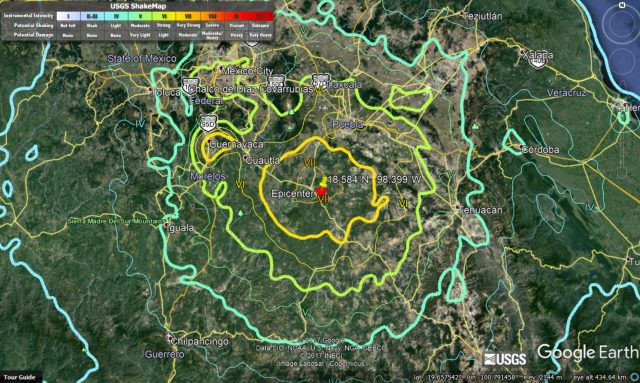
Google Earth image of the USGS intensity data for the earthquake at Raboso, Mexico
.
This map shows the area affected by Intensity of VI and greater:-
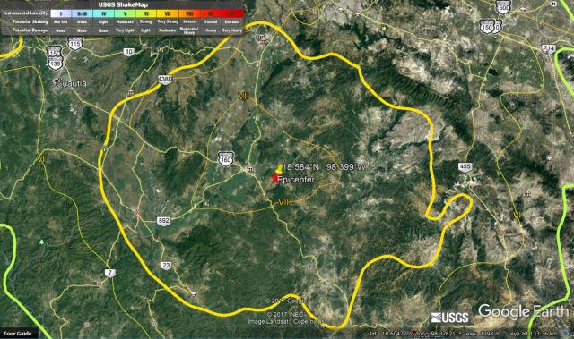
Google Earth image of the area with intensity of VI and greater, based on USGS data, for the earthquake at Raboso in Mexico.
.
Based upon this there is enough terrain to generate a significant number of landslides, although the relatively low relief suggests that these are likely to be mostly small and comparatively shallow. Further afield there is more significant terrain; it will be interesting to see if the shaking has been sufficiently large to generate landslides here. The depth of the earthquake suggests that the shaking will be generally strong but not extreme, but will have affected a broad area, giving landslide potential over a wide area.
Previous crustal earthquakes in Mexico have generated landslides. A few years ago we studied the landslide distribution from the 2010 M=7.2 Sierra Cucapah earthquake in northern Mexico (written up in Barlow et al. 2014). This was the event that generated the impressive youtube video of dust generation in the mountains. We mapped 452 landslides, which is not insignificant, but lower than normally expected, probably because of the arid conditions in northern Mexico. The area affected by the earthquake today is much less arid.
It will be much easier to understand the likely landslide distribution once we understand the fault that ruptured.
Reference
Barlow, J., Barisin, I., Rosser, N., Petley, D., Densmore, A. and Wright, T. 2014. Seismically-induced mass movements and volumetric fluxes resulting from the 2010 Mw = 7.2 earthquake in the Sierra Cucapah, Mexico, Geomorphology, Available online 24 November 2014, http://dx.doi.org/10.1016/j.geomorph.2014.11.012.
 Dave Petley is the Vice-Chancellor of the University of Hull in the United Kingdom. His blog provides commentary and analysis of landslide events occurring worldwide, including the landslides themselves, latest research, and conferences and meetings.