
31 July 2017
Saldim Peak in Nepal: a glacial flood that was actually caused by a giant rockslide
Posted by Dave Petley
Saldim Peak: a glacial flood that was actually caused by a giant rockslide
On 20th April 2017 a sudden flood/debris flow came down the Barun River below Saldim Peak in Nepal. This debris flow created a natural blockage on the Arun River, forming a lake that at its maximum extended for 3 km along the valley. This blockage breached naturally on 21st April, allowing the flood to dissipate.
The flood raised some interest at the time as it was captured by a German climbing team further up the Barun River:-
.
As the video showed there was substantial damage at the village of Yangle Kharka. It is perhaps fortunate that the landslide did not occur during the night.
At the time there was some speculation as to the cause of the landslide – interestingly the climbing team were clear that it had been triggered by a very large rockslope failure. Over the weekend, the Nepal Times has published an excellent article by Alton C Byers in which he describes a helicopter trip up the Barun Valley to investigate. His own words best describe what he found:
Three weeks later, I returned to the Barun Valley and spent the next three weeks studying the cause and impact of the Langmale outburst flood. Tashi Sherpa of the Makalu Basecamp Yak Hotel and Lodge in Langmale pointed to what was most likely the primary trigger: a massive rock wall that broke off from the southwest face of Saldim Peak (6,388 m) on the day of the outburst flood. This slope failure was possibly linked to the destabilising effects of the April 2015 earthquake, which had caused at least one other GLOF in the Everest region. The rock mass plummeted into the Langmale glacier below, in turn triggering an avalanche of ice, boulders, and debris that fell further into the Langmale lake.
The article includes this image of the scar from the landslide:-
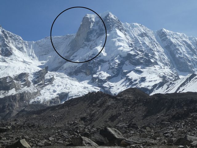
The scar from the Saldim Peak landslide on 20th April 2017, image by Alton C Byers and the Nepal Times
.
Interestingly, the author tracked down an eye witness to the event, who provided some insight into the chronology:-
Dendi Sherpa, a climbing guide, was camped 200m above Langmale lake with a client and says there were two rockfall events, the first at 3 pm and the second at 4:45 pm. Fog prevented him from seeing the avalanche and flood as they occurred, but Sherpa could hear it and surveyed the damage the next morning. We were thus able to reconstruct what was most likely the series of events that led to the Langmale GLOF in April.
The first slope failure was small and only caused a minor rise in the Barun’s water level, largely ignored by villagers living downstream in YangleKharka. The second slope failure, however, consisted of over 1 million m³ of solid rock that plunged 300m down to the Langmale glacier, creating a massive blast upon impact that hurled house size boulders and icebergs up to 1 km in all directions.
A huge cloud of whitish dust settled over everything—shrubs, boulders, lodges, mani walls–over a 12 sq km area. A debris flow of mud, sand, and rocks washed up and over the right and left lateral moraines and into adjacent basins to the east and west. Because the total estimated flood volume was far larger than that contained in the pre-flood Langmale lake, the flood was most likely composed of lake water, water created by friction during the rockfall, and/or water released from caves and conduits within the Langmale glacier.
The debris-filled floodwater cascaded over a 200 m rock wall and into the Barun river below, creating a huge torrent that picked up more material and debris as it barrelled down the Barun River. Massive new, canyon-like river channels and flood plains were created that destroyed hundreds of hectares of grazing and forest land, killed at least 24 yaks and dzo. The flood attenuated at the wide and flat valley of Yangle Kharka, but nevertheless continued its destructive journey downstream to dam at the Arun river confluence with the debris-choked floodwater.
This interpretation seems pretty good to me. I am not sure until now we realised that this was another very large rockslope failure. This is a Google Earth image of Saldim Peak (also known as Peak 5):
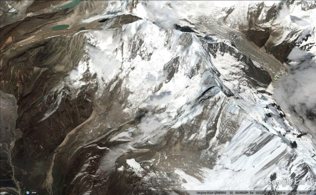
Google Earth image of Saldim Peak, the source of the large landslide that caused the Barun Bazar flood.
.
This was a very large rockslope failure – I suspect somewhat larger than the article suggests. This image shows the route of a planned climbing expedition on Saldim Peak:-
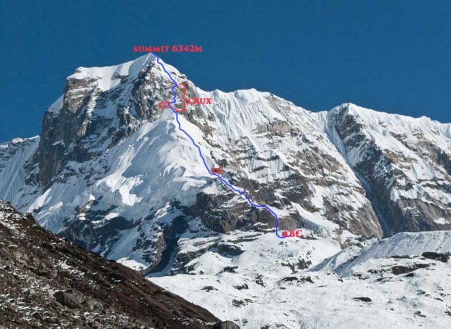
A planned climbing route on Saldim Peak. Compare the image with that taken after the landslide, above. The volume of missing rock appears to be very large.
.
The comparison between the trwo images of Saldim Peak suggests that a very large volume of rock has collapsed.
In many ways this event appears to be similar with the Seti River landslide and flood of 2012, which Colin Stark and I analysed extensively at the time.
 Dave Petley is the Vice-Chancellor of the University of Hull in the United Kingdom. His blog provides commentary and analysis of landslide events occurring worldwide, including the landslides themselves, latest research, and conferences and meetings.
Hi Dave,
I fully support your view that this event is of the same type as the Annapurna disaster of 2012. The only difference is that the Barun valley is sparcely populated. Remarkable is the observation that huge boulders and block were catapulted up to 1 km to all sides by a “blast” (remember my hypothesis of steam explosions due to impact of rock masses on glacier ice).
It is now more than 22 years ago that I had warned WB, German Ministry of Development and JICA to built the Arun III 2 GW hydropower station in that area. Barun valley had to be invastigated. In consequence, that project was given up and – instead – two smaller HP stations were built (Middle Marsyangdi and Kali Gandaki). The potential thread of of a GLOF from Thulagi glacier lake to Marsyangdi valley was investigated by us in 1996 with the result that we found the glacier lake dam in stable conditions.
In the meantime, China plans to built Arun III…
Best regards
Jörg