
14 July 2017
Understanding the La Palma mega-landslide hypothesis: part 2
Posted by Dave Petley
Understanding the La Palma mega-landslide hypothesis: part 2
Earlier this week I explored the main structural features of La Palma that have led some to propose that there is the potential for a mega-landslide there. This proposed volcanic flank collapse would be immense – the proposed volume is up to about 500 cubic kilometres. The idea that gained some popular traction is that this landslide could generate a tsunami that would devastate a large part of the coastline on both sides of the Atlantic.
Of course La Palma has undergone a previous flank collapse event, and there have been similar collapses elsewhere in the Canary Islands. Interestingly, none of these appear to have generated widespread tsunami deposits around the Atlantic basin. The key to the idea such an event developing again is the events of the major eruption in 1949. During this event, a fault structure was observed to develop along a part of the Cumbre Vieja ridge. This has been interpreted as indicating movement of the flank of the volcano towards the west, and thus the development of a potential flank collapse landslide on the southern part of La Palma. I spent a day up on Cumbre Vieja, with the main aim of taking a look at this fault scarp. Armed with a map from one of the key papers I roamed up and down the mountains on a most beautiful day. The feature that I found is remarkably unremarkable in landslide terms. Based upon the maps, the most obvious feature that I could find is the scarp shown below:-
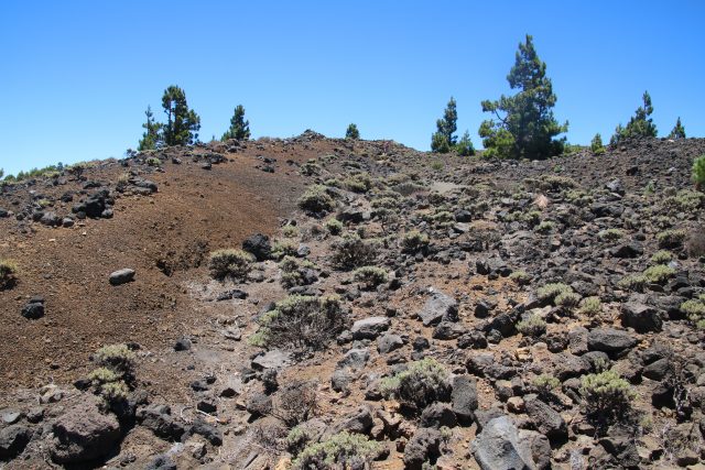
The possible fault scarp on the Cumbre Vieja volcano on La Palma, viewed from the north
.
This scarp is about 3 m high at the maximum – if you look carefully there is a person walking down the path for scale. It is reasonably clear in the landscape for some hundreds of metres before merging into the flank of one of the volcanic craters:
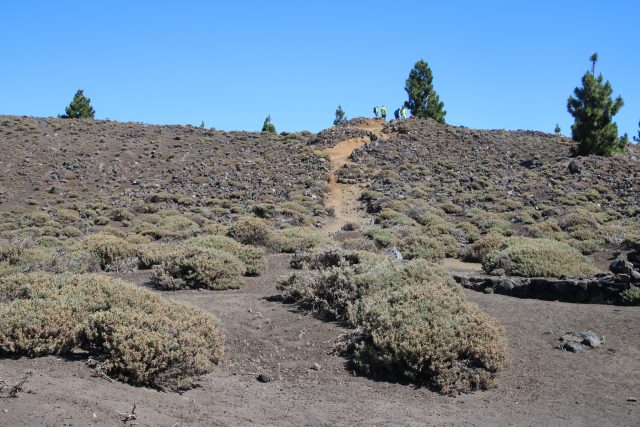
The apparent fault scarp on La Palma, viewed from the south. Note the people for scale.
.
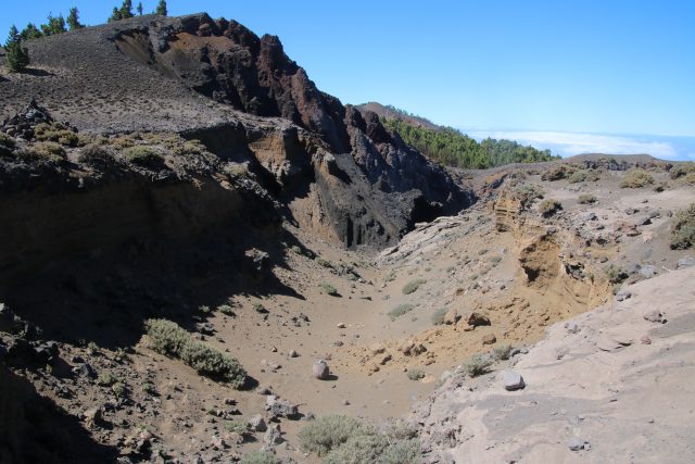
The trace of the fault scarp of Cumbre Vieja, merging into one of the volcanic craters.
.
I have to admit that I struggle to believe that this feature is a key component of the mega-landslide hypothesis given its small size, but I could not find any more convincing alternative. Perhaps I missed the correct feature. The scarp suggests limited movement on the landslide, even if it is a correct interpretation, suggesting in turn that an actual failure would be unlikely in the foreseeable future.
This fault scarp did not reactivate in the smaller 1971 eruption. Monitoring of the flanks suggest that there is no sign of rapid current movement on this scale, but that there may be some signs from satellite data of very low velocity creep on this slope, which is not a surprise (this may well be true of all large slopes in weak materials). Thus, the mega-landslide hypothesis is that this volcano would only become unstable in a future eruption, and that in such circumstances the flank could collapse in a single coherent block to generate the tsunami. The paper that modeled the tsunami, Ward and Day (2001) modeled a landslide of about 450 cubic kilometres – i.e. they took the very largest volume that is imaginable. This seems a little odd to me – the rear scarp of their mega-landslide appears not to mobilise the scarp shown above, but one considerably to the east, creating a much larger block. I am not sure that I understand the reasoning for this. The model then assumes a series of extreme scenarios:
- The landslide occurs as a single coherent mass along the entirety of the ridge (thus over a distance of 25 kilometres);
- The landslide occurs as a single coherent mass through the cross-section (i.e. there is a single failure event over the 15 kilometre cross-section of the slope, rather than a series of retrogressive slip blocks);
- This huge block remains intact over a travel distance of 15 km before fragmenting;
- The landslide mass rapidly reaches a peak velocity of 100 m/sec (360 km/h)
A change (reduction) in any of these parameters would yield a much smaller tsunami. For example, subsequent work (Abadie et al. 2012) has taken the ““credible worst case scenario” (derived using slope stability analysis), to have a volume of 80 cubic kilometres (but note the factor of safety of the slope was found to be considerably higher than one, indicating that the slope is not particularly unstable). Modelling of the tsunami generated by such a landslide, using a more refined tsunami simulation, does generate a very significant wave close to La Palma. This wave would be significant as it crossed the continental shelf off the east coast of North America, but would lose a great deal of energy due to frictional effects in this region. Thus, for a 80 cubic kilometre “credible worst case scenario” flank collapse on La Palma, wave heights on the east coast of the USA were found by Tehranirad et al. (2015) to be less than 2 metres along the coastline.
This is not the disastrous scenario that the newspapers have so enjoyed featuring.
References
Abadie S., Harris J.C., Grilli S.T. and R. Fabre, 2012. Numerical modeling of tsunami waves generated by the flank collapse of the Cumbre Vieja Volcano (La Palma, Canary Islands) : tsunami source and near field effects. Journal of Geophysical Research, 117: C05030.
Tehranirad, B., Harris, J.C., Grilli, A.R. et al. 2015. Far-Field Tsunami Impact in the North Atlantic Basin from Large Scale Flank Collapses of the Cumbre Vieja Volcano, La Palma. Pure and Applied Geophysics 172: 3589.
Ward S. N. and S. Day, 2001. Cumbre Vieja Volcano potential collapse at La Palma, Canary Islands. Geophysical Research Letters, 28: 397–400.
 Dave Petley is the Vice-Chancellor of the University of Hull in the United Kingdom. His blog provides commentary and analysis of landslide events occurring worldwide, including the landslides themselves, latest research, and conferences and meetings.
Have studies of prior La Palma flank collapses determined sea level ? A glacial low-stand may mask far-field evidence for a non-worst-case, but still ‘very nasty’ midi-tsunami…
Well looks like we are going to test your theory! La Palmas latest earthquake brought me here. Here’s hoping it doesn’t case a land slide.
I am in Florida and trying to find Reliable information about current events pertaining to this potential tsunami unfortunately there is limited information and somehow I think our government would definitely delay letting Florida know what was happening Florida is not Biden favorite place
Try this and go to latest news. https://en.as.com/
The only President in living memory known to pettily play favorites among blue and red states in a disaster was the recent and former President Trump. I see no reason to expect Biden to do the same. Whether you like him or not, he does not have the same mean, vindictive, personally petty streak. Trump literally threatened that states better be nice to him if they wanted resources.
Agree. I’m in Florida also. Which part?
You’re also aware of the failed buoy system that would give us ample notice to escape? If this were to happen media would notify when it’s always too late.
Thanks for the political input simpleton. Much more likely the previous president would withhold info for political retribution. Ref. California wildfires.
Hello Jane,
I agree with you 100% Biden and the cabal would love to see a tragedy happen to humanity. Those that don’t see it have no common sense or are pure evil. Have faith, based on research there will not be any tsunami or disasters. You can join me on telegram https://t.me/eastcoastUSA If I hear anything will post there also if you need to vent. We have to stand together. Spread love and remember we are more powerful than we have been conditioned or indoctricated to be.
Basically the facts are (1) The flank does fall off from time to time (8 noted in ocean), (2) past falls show no evidence of a mega-fall, and (3) the total at risk due to “build” up is 500 cubic kilometers enough for a mega-event. So the question comes down do .. can a mega-event happen where it all slides at once. And answer to that is yes BUT the combination of factors to do so would have to be just right. If you get a large enough eruption, the moving lava in the tubes might heat up the water in the ground leading to pressure everywhere. Essentially you need enough heat on the water under ground so they whole thing swells a bit to loosen it, and themore steam produced the better. Of course you also need some water to remain as a lubricant to reduce the level of friction so a cascade slide event can occur. So too hot and it starts bursting the rocks with pressure and the thing falls off in pieces. When it’s just right, with everything swollen and pushed out, the reamining water acts as a lubricant. And once something starts sliding the whole thing can cascade .. in Theory. In practical terms the odds are very very low.
Some hours later- have the odds changed at all? – or is this something that might take days or even weeks before we know whether it will happen or not?
You say the odd as are very low but has this changed in the last few hours? – if not – how long will it be before we know whether or not there is likely to be a flank fall and consequent tsunami ? – could it be weeks or months even?
Very curious as well. Can’t find much good information online
Days, Weeks or months. Listen to the Feb 9 2012 podcast by Bill McGuire at http://podacademy.org/podcasts/the-earth-is-not-so-solid/
What is unsettling is the lack of coverage of this in the press in a meaningful way. A conspiracy of silence.
I found this 2nd page after posting to the first page. I will comment that the rift that DP had trouble finding is much more apparent further to the north. In amongst the woods to the S of the LP301 road was a 5-7 metre deep gully with the western side lower than the higher eastern side. I walked along a stretch of about 50m before stopping. The gully continued as far as I could see into the trees.
My previous post on P1
I lived on La Palma for 7 years back in the 90’s. Working at the observatory. Whilst walking above my house near the airport and below San Antonio I noticed a patch of white rock amongst the black. Investigating I found it to be embedded sea shells. The height was 110 metres above sea level. I couldn’t understand how they got there until I saw the MT theory some years later. Also a short while later whilst walking on the western flank of the Cumbre Vieja I came across a long N/S gully which was strange as all the other gullies ran E/W down the hill. This I discovered was the slump in the western flank from the 1949 eruption.
The current situation has 2 things going for no slump and that is the present eruption is away from the CV rift line and secondly the presence of numerous water “mines” which extract groundwater thereby taking away the expanding liquid which forms part of the slump hypothesis.
Worryingly though I have noticed in the last few days that the earthquake swarm around the current eruption S of El Paso has suddenly moved to the fault line along the Cumbre. This may mean a second vent along the summit may open. More worryingly still is that the location of 4 earthquakes have been along the slump line from the 49 eruption. I am extremely concerned.
[Thank you, but don’t be too concerned. At the moment the deformation monitoring does not show any signs of movement of the flank in response to the eruption, as far as I can see. D.]
DP Thanks for your reply.
Any reason you can think of that the earthquake swarm has moved so distinctivley to the cumbre?
In many landslips there is a distinctive pre slip movement but there are other landslides (as far as I know) that happen without warning. Since the extensive seismic activity at the cumbre began would there necessarily have to be deformation? Couldn’t an already weakened fault line (from 1949) be liable to catastrophic failure?
[I’m no expert on volcanic seismicity, so I’m not sure to be honest. The original hypothesis for the giant flank collapse arose in part because the team detected that the flank was apparently creeping. I think it’s highly unlikely that this slope would fail without precursory deformation. Of course, even if it did fail it is unlikely to generate a mega-tsunami. D.]
Regardless of the overall risk appraised here, strange to hear partisan mentions of current and former US presidents, in comments.
Why wouldn’t there be a clear comment and post here on the measurements and early warning signals of changing and increasing geothermic activity.
Just one event may not be the measure of the whole picture, globally. Please provide clear and up to date references to studies and modelling.
I HIGHLY doubt the giant Tsunami theory now that I have done my research. It is very unlikely. I finally found a good article.
http://www.drgeorgepc.com/TsunamiMegaEvaluation.html
You guys seemed very interested to know so I thought I would post this.
Mega landslide possibility? Yes
Mega Tsunami possibility crossing 3000 miles of ocean? No, absolutely not.