
12 July 2017
Understanding the La Palma mega-landslide hypothesis: part 1
Posted by Dave Petley
Understanding the La Palma mega-landslide hypothesis: part 1
As I noted in an earlier post, I spent a part of last week on the island of La Palma in the Canary Islands. Whilst my visit was to mark the opening of the GOTO telescope in my Vice-President role, I also took two days to explore the supposed mega-landslide that, it has been suggested, could generate a huge and very damaging tsunami. I have noted before that I do not subscribe to this hypothesis, but welcomed the opportunity to explore the site. In this and at least one subsequent post I will try to explain the mega-landslide hypothesis, and will also seek to outline why I do not think it stands up to scrutiny.
The La Palma volcanoes
The Google Earth image of La Palma below shows the main features of the island. I have provided an annotated version on the left alongside an unannotated version for clarity:-

The main structural features of the island of La Palma, via Google Earth
.
The main features are, first, the Taburiente Volcano to the north. This is a large shield volcano that reaches almost 2500 metres above sea level (and thus about 6500 m above the sea floor). This started to form about 2 million years ago, and slowly extended to the south to form a ridge, called Cumbre Nueva. This is the Taburiente Volcano from the south:-
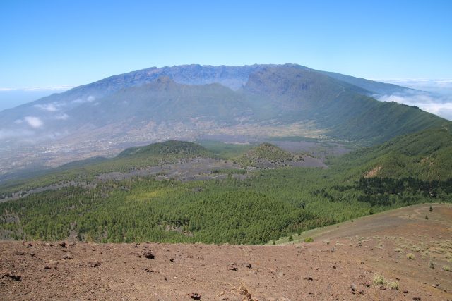
Taburienta Volcano in the background, with Bejenado in the middle distance.
.
About 560,000 years ago the Cumbre Nueva ridge underwent a giant landslide, when up to 200 cubic kilometres of the volcano slipped towards the west into the ocean, leaving the giant Cumbre Nueva scarp. This feature can be clearly seen in the satellite image and in the photograph above, and is more obvious in the image below. The presence of this giant landslide has also been detected in the offshore bathymetric data. It is likely that this event generated a large local tsunami, but as far as I am aware no evidence has been found of a tsunami deposit from this event beyond the Canary Islands.
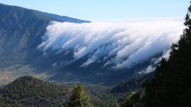
The Cumbre Nueva landslide scar, with a waterfall of cloud.
.
The easterly winds cause clouds to form as the air rises up the slopes of the volcano. These clouds then tumble over the landslide scar to form the cloud waterfall shown above.
Bejenado volcano erupted into the scar left by the Cumbre Nueva landslide, blocking a part of the drainage from Taburiente. This led to rapid erosion and formation of the enormous Calder de Taburiente, which can be seen in the image below:-
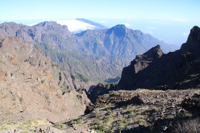
The Caldera de Taburiente and, in the background, Bejenado volcano.
.
Thereafter volcanic activity has been mainly focused on the volcanoes to the south, which form the Cumbre Vieja ridge. These volcanoes remain active, and indeed erupted in both the 1940s and the 1970s. It is this part of La Palma that, it has been suggested, may be structurally unstable. This image shows one of the many volcanic cones along Cumbre Vieja:-
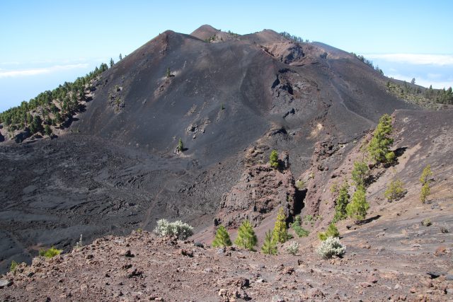
One of the volcanic cones along the Cumbre Vieja ridge. This is Crater de Duraznero, which reaches 1949 metres above sea level.
.
Note the major lava flow at the foot of the volcano.
In the next post I will explore the idea that the Cumbre Vieja volcano system may undergo a flank collapse event.
 Dave Petley is the Vice-Chancellor of the University of Hull in the United Kingdom. His blog provides commentary and analysis of landslide events occurring worldwide, including the landslides themselves, latest research, and conferences and meetings.
i had read about the canary landslide tsunami theory for years in various publication,books and even a disaster type show on cable.
I find it interesting no geologic evidence of any east coast tsunami from the 560,000 year slide.Wasnt aware core sampling of coastline or inland area had ever been done looking for sand /shell deposits at that level/depth.Fascinating.
Along the Severn Estuary on the English side, deposits of shells etc have been found miles inland. It is always said that a tsunami washed up the Severn Estuary destroying several villages and killing hundreds of people. It is also said that the tsunami started from the Canary Islands, La Palma. Folklore or true – no idea.
[This is the 1607 flood event, which did indeed cause substantial levels of damage. The hypothesis that this was a tsunami has been proven to be incorrect – the event was a weather induced storm surge. D.]
There was a tsunami in the East Coast. 1929. Grand Banks. 7.2 mag.
All it takes is one massive quake, which are increasing around the globe. Low risk does not equate to no risk. Underestimation is a massive killer.
How do I make a comment of my own, and not merely reply to a post by ‘Kent’?
Everybody has cognitive bias against bad news, the pandemic is teaching us well on that.
I lived on La Palma for 7 years back in the 90’s. Working at the observatory. Whilst walking above my house near the airport and below San Antonio I noticed a patch of white rock amongst the black. Investigating I found it to be embedded sea shells. The height was 110 metres above sea level. I couldn’t understand how they got there until I saw the MT theory some years later. Also a short while later whilst walking on the western flank of the Cumbre Vieja I came across a long N/S gully which was strange as all the other gullies ran E/W down the hill. This I discovered was the slump in the western flank from the 1949 eruption.
The current situation has 2 things going for no slump and that is the present eruption is away from the CV rift line and secondly the presence of numerous water “mines” which extract groundwater thereby taking away the expanding liquid which forms part of the slump hypothesis.
Worryingly though I have noticed in the last few days that the earthquake swarm around the current eruption S of El Paso has suddenly moved to the fault line along the Cumbre. This may mean a second vent along the summit may open. More worryingly still is that the location of 4 earthquakes have been along the slump line form the 49 eruption. I am extremely concerned.
I find volcanos very fascinating geology has always interested me, when I started watching the eruption on youtube.com I became more fascinated and started to search for information on line. I typed in search “what stage is the volcano in La Palma” this link appeared, as well did the link to this current web sight. I thought you may find it very interesting it was published in 1999 and the study was conducted by an actual volcanologist as well as 3 other scientist. Here is the link https://pubs.geoscienceworld.org/gsa/gsabulletin/article/111/5/755/183497/Later-stages-of-volcanic-evolution-of-La-Palma
This is the title of the research study:
RESEARCH ARTICLE| MAY 01, 1999
Later stages of volcanic evolution of La Palma, Canary Islands: Rift evolution, giant landslides, and the genesis of the Caldera de Taburiente
Please check out this research study conducted in 1999 it may interest you and anyone else I found it today after searching for what stage is the la palma volcano currently
https://pubs.geoscienceworld.org/gsa/gsabulletin/article/111/5/755/183497/Later-stages-of-volcanic-evolution-of-La-Palma
RESEARCH ARTICLE| MAY 01, 1999
Later stages of volcanic evolution of La Palma, Canary Islands: Rift evolution, giant landslides, and the genesis of the Caldera de Taburiente
Jerdith, Thanks for that I had seen the paper before but only abstracts. So it’s interesting to get the full article.
One item of note is that the 1949 eruption had two vents one approximately where the current eruption is taking place and another on the summit ridge of the CV where the lava flowed down the eastern flank toward the sea.
Currently the earthquake swarm that began this eruptive cycle began S of El Paso and within the last few days has moved suddenly south to the CV region. You can see this by visiting http://www.ign.es/web/resources/sismologia/tproximos/prox.html and switcjing between the last 3 days and the last 10 days
I wonder if another vent is about to open up? What do you reckon?
Quero abrir um parêntese apenas e elogiar essa página, tanto pela explanação do evento como até agora os comentários feitos. Parabéns pela página no âmbito geral, é notório a essência voltada não apenas ao conhecimento postado, mas também ao nível excelente dos comentários. Isso sim é a maneira de se discutir assuntos, até mesmo um leigo como Eu, se sente confortável em adquirir conhecimento. Carlos Magno Abreu – BRASIL – Recife – PE
[Translation: I want to open a parenthesis only and praise this page, both for the explanation of the event and the comments made so far. Congratulations on the page in general, the essence focused not only on the knowledge posted, but also on the excellent level of comments is notorious. Now that’s the way to discuss matters, even a layman like Me is comfortable acquiring knowledge. Carlos Magno Abreu – BRAZIL – Recife – PE D.]
I too, find these comments very well researched and explained. Nice to know various levels of experience and researched data have been shared. Wanted to say thanks to all, and continue to point out the changes that you are seeing and discovering from the charted data. I learn something new every day. Googled how to read the earthquake graph paper just the other day. take care.
I’m wondering, as of today, Oct 6, 2021, the lava is forming a huge delta on the western shore of La Palma! How much added weight would it take to cause the rift to break into FULL SLIPPAGE? Aren’t we looking at a calculable outcome? I can’t believe no-one is addressing this!
I’m wondering, as of today, Oct 6, 2021, the lava is forming a huge delta on the western shore of La Palma! How much added weight would it take to cause the rift to break into FULL SLIPPAGE? Aren’t we looking at a calculable outcome? I can’t believe no-one is addressing this!
[Interesting point. According to the Smithsonian:
“Within the first eight days of the eruption, 21-27 September, an estimated 50 million cubic meters of material had been erupted.”
This is now likely to be c.3x as large, so a back of the envelope number is 150-200 million cubic metres. The location of the material is such that it is likely to reduce stability slightly. However, in the context of the entire slope the additional load is very small. As Wikipedia describes it:
They used a scenario of a collapse of 500 cubic kilometres (120 cu mi) that moves at a rate of about 100 metres per second (330 ft/s) on top of a layer of mud or landslide breccia, which lubricate its movement, and eventually spreads 60 kilometres (37 mi) to cover a jug-shaped area of 3,500 square kilometres (1,400 sq mi).
So overall the effect of the delta in terms of overall stability is likely to be very minor. At the moment there is no sign of destabilisation of the flank. D.]
At present the seismic activity is located under Hoyo Negro and some to the eastern side of the island with a ground swell of over 190mm in places. The volcano is venting closer to the San Juan fissures so this means the Magma is migrating North East along a fault line and I believe the 3m drop occurred after a previous eruption when the magma pressures reduced and the rocks cooled.
People are saying FL will be under water due to this …I cant help but wonder my self
So with current uplift of possible 15 cm on the north end of the island and some sections of the western flank showing it is sinking, What are the possibilities of the western flank landslide happening?