
18 April 2017
The Almaluu-Bulak landslide in Kyrgyzstan: amazing new Google Earth imagery
Posted by Dave Petley
The Almaluu-Bulak landslide in Kyrgyzstan: amazing new Google Earth imagery
Possibly the most astonishing landslide video of 2016 showed the Almaluu-Bulak landslide in Kyrgyzstan. I wrote about it at the time, and also managed to pin down the location. The video is worth seeing a second time:
.
This was the second, larger, event in the sequence, both of which occurred on 27th April 2016. One person was killed.
Last month, the Google Earth Blog wrote about this landslide. The prompt was new imagery in the tool that captures the before and after situation of this landslide, and the adjoining area. And wow, this is worth a look. The easiest way (assuming you have Google Earth) to view the images is via this KML file. They have even mapped some of the landslides, though a quick inspection shows that there are many, many more. Indeed this is a landscape that is dominated by landslide processes.
But, in terms of the Almaluu-Bulak landslide itself, the imagery is fantastic. This is the image collected in November 2016:-
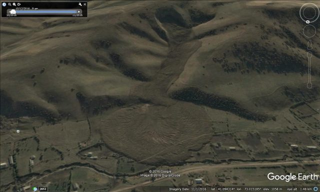
Google Earth image of the Almaluu-Bulak landslide in Kyrgyzstan
.
It is a most beautiful example of a flowslide. The deposit at the toe is very similar to the deposits seen at the toe of some flume experiments when the flume toe is planar, unrestricted surface, although others will be able to better comment on this.
A really interesting aspect is the before and after comparison of the source area. This is an image after the event:
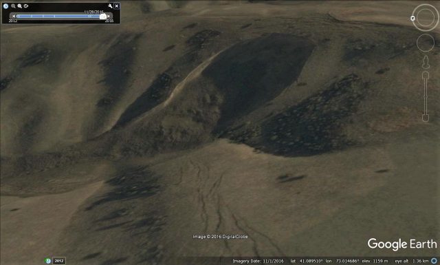
Google Earth imagery of the aftermath of the Almaluu-Bulak landslide in Kyrgyzstan
.
Note the cracks in the hillslope in the foreground, and behind the crest of the landslide scar. But look at this image, taken two months before the failure event, from the same perspective:
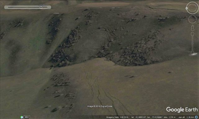
Google Earth imagery of the source of the Almaluu-Bulak landslide, taken two months before the failure
.
Note the multiple arrays of cracks in the source area. This was a landslide that was developing over a long period. Interestingly, these cracks do not correspond to the current back scar. But we know that two failure events occurred in close succession. I would hypothesise that these crack define to source of the first landslide, whilst the second occurred because of toe release by the first.
The large cracks behind the scar suggest that there is a risk of a third, possibly even larger, event at this site, but that can only be ascertained with a more detailed analysis that involves fieldwork.
 Dave Petley is the Vice-Chancellor of the University of Hull in the United Kingdom. His blog provides commentary and analysis of landslide events occurring worldwide, including the landslides themselves, latest research, and conferences and meetings.
Amazing video and images. Thanks Dave!