
18 July 2016
Monsoon 2016: Nepal reels under the effects of multiple landslides
Posted by Dave Petley
Monsoon 2016
In the aftermath of the May 2015 earthquake we have been worried that the first really intensive period of rainfall would lead to significant landslide problems in Nepal. Unfortunately, as Monsoon 2016 really gets into gear this scenario is playing out. Northern areas of Nepal are being affected by large amounts of rainfall. The landslides are dominating the news in Nepal – for example this is the front page of the Himalayan Times this morning:-
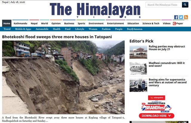
Monsoon 2016: The front page of the Himalayan Times this morning
.
This is reporting the ongoing problems in the catchment of the Bhote Kosi following the landslide dam break flood of last week. Whilst the damage and disruption to this area is undoubtedly extreme, I am deeply concerned by this report of plans to bulldoze a new, 26 km long track to create an alternative alignment to Tatopani:-
The Divisional Road Office (DRO) has started work to open a 26-kilometre alternative track to connect Barhabise with Tatopani in Sindhupalchok district after a flashflood last week destroyed much of the road. The under-construction Middle Bhotekoshi Hydropower Project is providing financial assistance to open the road from Chaku to Khohra. The DRO has started construction in the remaining section of the road up to Tatopani. The project has already opened the alternative way from Chaku. The project is using three excavators at the site. Chief of the 102 megawatt project Sunil Kumar Lama said landslides continue to occur in Khohra and other areas. Senior civil engineer Sanjay Sapkota said construction works will be completed in a week though the river is still eroding sections of the Araniko Highway.
These low tech roads are both environmentally catastrophic and exceptionally hazard prone. This is an area that basically consists of quasi-stable landslide deposits, and even the existing road is very landslide-prone. In the medium term the opening of a new road is likely to make the problem far worse.
Meanwhile, other catchments are also showing distinct problems. The Mahakali River is reported to be very high and is actively eroding its banks:-
A flood in Mahakali River has started eroding the embankment at Bhimdatta Municipality-11 in Kanchan-pur district. On Sunday, the river eroded the levee that was constructed near Bhujela last year. Technicians from the People’s Embankment Programme (PEP), Kanchanpur said the flood caused by incessant rains in the hilly areas of the far-western region started eroding the banks on Saturday night. PEP chief Bhilananda Yadav said the embankment would be destroyed if the dike is swept away. “We are going to protect the embankment with gabions,” he said. Shankar Chhetri of Bhujela said they have been alerted against the river flooding their settlement.
Perhaps most worrying is the situation on the Tamor River, which has been partially blocked by a landslide. News yesterday was that the water level is rising:
Water level in landslide-dammed lake in Tamor River in Sawadin, Taplejung, has increased, leaving the downstream settlement at risk. A fresh rockfall blocked water flow in the river. Pawan Shrestha, a resident of nearby Mitlung Bazaar, told the Post over the phone that the water level in the debris-dammed lake gradually increased on Saturday.
The Kathmandu Post published an image last week of the landslide and lake from the upstream side:
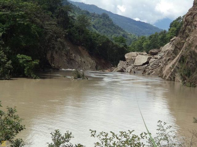
Monsoon 2016: Kathmandu Post image of the landslide dam on the Tamor River
.
 Dave Petley is the Vice-Chancellor of the University of Hull in the United Kingdom. His blog provides commentary and analysis of landslide events occurring worldwide, including the landslides themselves, latest research, and conferences and meetings.