
10 September 2015
The West Salt Creek Landslide, Mesa County – implications for hazard management
Posted by Dave Petley
The West Salt Creek landslide, Mesa County
An interesting part of the Colorado Geological Survey report into the West Salt Creek landslide in Mesa County (White et al. 2015) is the section on long term implications and hazard management. It is worth looking at this section is a little more detail as it has wider ramifications.
Future hazards associated with the West Salt Creek landslide
The first part of this part of White et al. (2015) looks at the hazards associated with the West Salt Creek landslide itself, and the implications for this part of Mesa County. The most important element of this is the behaviour of the upper part of the landslide. The upper rotated block is shown in the photograph below, from White et al. (2015):
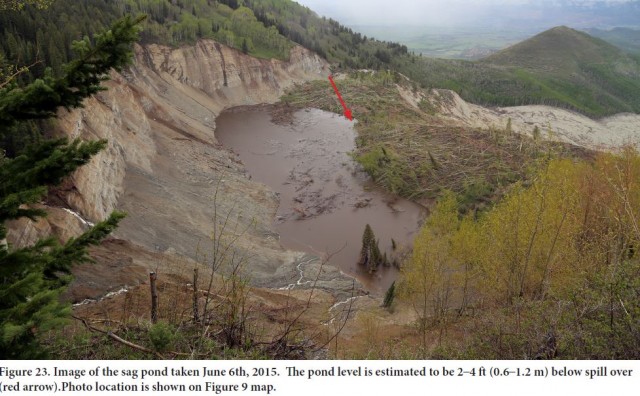
West Salt Creek landslide, Mesa County from White et al. (2015)
.
White et al. (2015) consider whether the rotated block is stable, concluding that it probably is, although its stability may be greatly reduced if the water level in the sag pond becomes too high. The sag pond itself came close to overtopping earlier this year, but is being drained through natural seepage. It is clear that there is considerable uncertainty as to how this system will behave in the future. There seems to be a higher level of concern about the stability of the steep slopes that form the headscarp, which shows signs of active deformation. White et al. (2015) raise the possibility that a failure in these slopes could lead to a comparatively large volume of material entering the sag pond, which could overtop to create another flow type event. This would appear to me to be a real concern, and probably needs both further investigation and an active monitoring programme (see below).
The report also raises the possibility of reactivation of portions of the flow deposit. White et al. (2015) note in particular that the rock blocks that form the deposit weather quickly when exposed to the air through slaking. This has the potential to reduce their strength, and thus to increase the likelihood of mobility. Combined with the potential for either further failures or reactivations of parts the upper slopes and/or parts of the the rotated block, or of the release of water from the sag pond, the likelihood of further flows cannot be ruled out. In addition the landslide will release sediment into the watercourse, which will have implications downstream. Thus, the landslide presents quite a challenge for Mesa County.
Recommendations beyond the boundaries of the West Salt Creek landslide
White et al. (2015) also consider the wider implications of the landslide. They note that the existing landslide mapping in this region is not adequate. Given that landslides of this type cannot be mitigated, avoidance and management of areas at risk is the only sensible approach to hazard management. The availability of high resolution LIDAR data means that the compilation of a high quality landslide map is possible. This is particularly pertinent in the context of the oil and has facilities in Mesa County – the report includes the following map of the locations of oil and gas facilities in the local area:
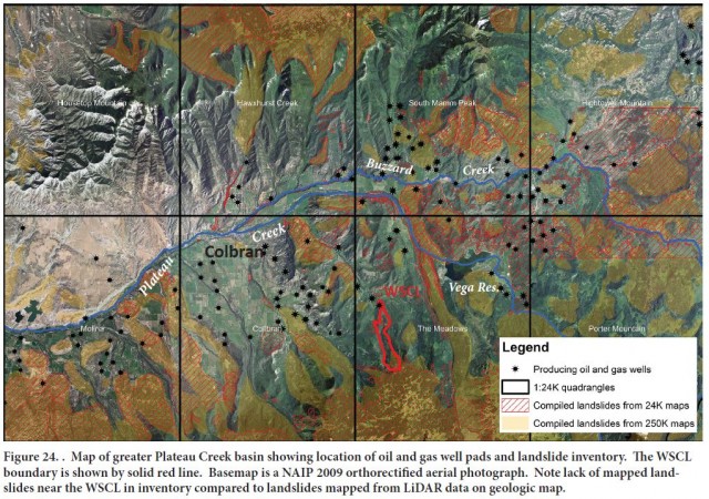
Map of oil and gas facilities in this part of Mesa County, from White et al. (2015)
.
And of course the report, quite rightly, recommends more detailed monitoring of the head scarp area of the West Salt Creek landslide. Whilst expensive, this would seem to me to be essential. In the meantime, the report supports the closure by the US Forest Service of the land affected by the landslide itself and the areas adjacent to the headscarp. Given the uncertainties around future behaviour, this seems very prudent.
It is hard to disagree with the conclusions and recommendations of the report, but in my view the measures proposed need to be underpinned by a systematic, long term landslide hazard mapping programme that covers a much wider area. Whether there is an appetite to incur this level of cost is unclear however. There is an excellent landslide inventory for the state on the Colorado Geological Survey website, but this has the caveat that:
This landslide inventory only reflects the location of landslides digitized from existing maps prepared by many different authors. No original landslide mapping was completed for this inventory.
Reference
White, J.L., Morgan, M.L. and Berry, K.A. 2015. The West Salt Creek Landslide: A Catastrophic Rockslide and Rock/Debris Avalanche in Mesa County. Colorado Colorado Geological Survey, 45 pp.
 Dave Petley is the Vice-Chancellor of the University of Hull in the United Kingdom. His blog provides commentary and analysis of landslide events occurring worldwide, including the landslides themselves, latest research, and conferences and meetings.