
23 March 2015
Yeager Airport slope failure: deformation for two years prior to collapse
Posted by Dave Petley

Yeager Airport slope failure
Whilst the immediate crisis appears now to have passed, the Charleston Gazette has been investigating the Yeager Airport slope failure. Today they have published a very interesting article about the landslide, focusing on the pre-failure deformation of the slope. It is well worth a read – real investigative journalism. This is the time line:
June 2013: Staff at Yeager Airport noticed cracks appearing in the EMAS at the top of the slopes (EMAS is the concrete block system designed to safely stop aircraft that have overrun the airport). S&S Engineering wrote in a report for Yeager Airport that “The joint tape used to seal the blocks was tearing and separating allowing rainfall to enter block joints. Airport personnel became concerned that the cracks in the asphalt extend under the EMAS blocks allowing the rainwater to enter the engineered fill material.”
October 2013: Triad Engineering, the designer of the structure, surveyed the site.
February 2014: Triad Engineering surveyed the site again, and found deformation over the intervening four months of one to three inches (2.5-7.6 cm). However, total movement from the as-built survey was much greater. The Charleston Gazette reports that “The southwest corner of EMAS has moved forward 1.3 feet along the projected centerline, 2.7 feet to the left and 3 feet downward”, quoting from an S&S Engineering report, which is available online.
July 2014: Triad Engineering installed 24 monitoring points. All showed movement over the next month of up to 2 inches (5 cm).
early March 2015: Triad Engineering hired Rick Valentine, an expert in geo-reinforced slopes, to help monitor the slope.
8th March 2015: Triad Engineering initiated a site investigation to evaluate the movement of the fill
10th March 2015: Settlement of the southernmost corner of the fill “became more pronounced”
11th March 2015: Yeager Airport held an emergency board meeting. The Charleston Gazette reports that ‘an engineer told the board that the chances of a catastrophic failure were “very, very slight’. However, the area of Keystone Drive at the foot of the slope was evacuated.
12th March 2015: The slope failed.
The development of a slope failure can involve a feedback loop in which initial movements of the slope open cracks that permit increased infiltration, generating higher water pressures, more movement and wider cracks, and so on. Fill slopes, which are very vulnerable to high water pressures, can be particularly problematic. So it is inevitable that questions will be asked about how this ongoing deformation was allowed to develop without more intervention. It would be very interesting to see the monitoring records for the survey points. By February 2014, a year before the collapse, quite large deformations had developed. I am surprised that this did not generate a much higher level of concern, but that its of course easy to say in retrospect.
The cause of the collapse remains unclear – I have yet to see anything to clarifies as to whether this was caused by a failure in the fill (i.e. the geosynthetic reinforcement was not up to the task?) or in the foundation. Given that this is reportedly the highest slope in the world that is reinforced with geosynthetics, there will be a great deal of interest in knowing what went wrong at Yeager Airport. The Charleston Daily Mail has a nice interview with Rick Valentine, who explains what happens next in the search to understand the Yeager Airport slope failure.
 Dave Petley is the Vice-Chancellor of the University of Hull in the United Kingdom. His blog provides commentary and analysis of landslide events occurring worldwide, including the landslides themselves, latest research, and conferences and meetings.
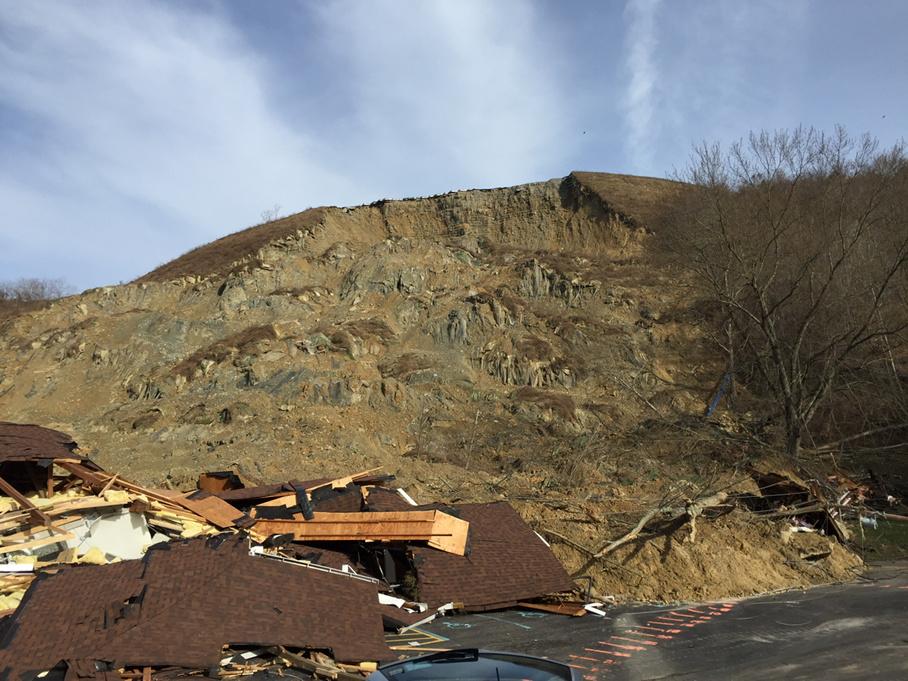
Two story’s featuring a slide event from 1970 at Yeager
http://imgur.com/a/dBOYs