
17 March 2014
Mount Haast: A GNS report on the 2013 rock avalanche (which is also known as the Mount Dixon rock avalanche)
Posted by Dave Petley
Mount Haast rock avalanche
A little over a year ago Neil Wiltshire, a British climber, captured on video a rock avalanche on the flanks of Mount Haast (although at the time this was reported as being from Mount Dixon). I posted a couple of times on this landslide. The full video, surely one of the most remarkable ever collected, is still available on Youtube:
..
Last year, Graham Hancox and from GNS Science and Roydon Thomson, a local engineering geologist, wrote a report (Hancox and Thomson 2013) on this landslide, which has now been made available online (NB pdf). The report also covers another landslide, which occurred two weeks earlier at Ball Ridge, 9 km from Mount Haast) a fortnight or so earlier. I do not intend to discuss that landslide here.
The characteristics of the Mount Haast landslide
Although the video and subsequent analyses are the main sources of information about the landslide, the report also includes this image, collected by Anna Seybold, od the landslide in motion:
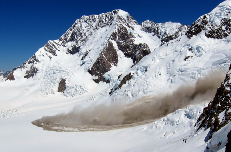
Photo: Anna Seybold, from Hancox and Thomson (2013)
..
This image is really interesting as it appears to capture the transition from turbulent rock avalanche to rapid sliding. If you view this image alongside the video it is clear that the front of the landslide appears to have just started to slide. The report suggests that at its peak the landslide was moving at about 150 km/h. The landslide characteristics are as follows:
- Source area width: 200-250 m
- Source area height: 350-400 m
- Source thickness: 5-25 m
- Initial volume: 575,000-980,000 cubic metres
- Average velocity (from seismic data): 160 km/h
- Runout distance: 2.9 km
- Deposit volume: 2 million cubic metres (NB this is larger than the source volume because of entrainment en route)
The report has very nice before and after images of the landslide:
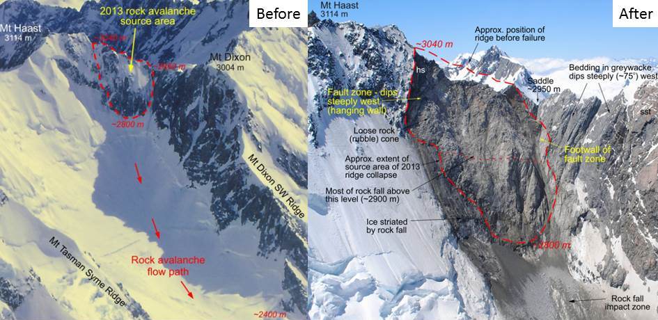
Images from Hancox and Thomson (2013)
..
But perhaps the most useful part of the report is the combination of these two images, the one on the lefty showing the landslide track and the one on the right providing a long section of the slide:
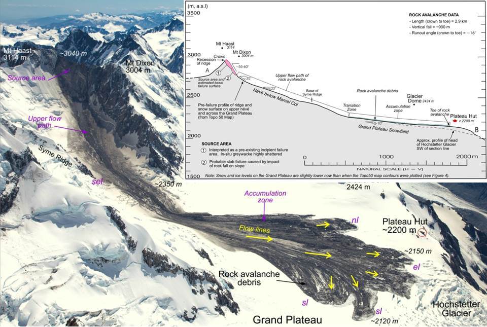
Adapted from Hancox and Thomson. Photo by Mark Watson
..
What is beautifully shown in this image are the four phases of movement:
- Initial freefall
- Rock avalanche, characterised by a steep track and dust deposits on both sides. When the gradient reduced this transitioned to…
- Rapid sliding, during which the main body developed very clear flow lines
- Slow sliding, in which the deposit developed the lobate frontal structure and entrained fresh snow and ice.
There is a great deal more in the report, including a very interesting discussion about causation and triggering. I recommend that you download a copy.
Reference
Hancox, G.T. and Thomson, R. 2013. The January 2013 Mt Haast Rock Avalanche and Ball Ridge Rock Fall in Mt Aoraki/Mt Cook National Park, New Zealand. GNS Science Report 2013/33. 26 pp.
 Dave Petley is the Vice-Chancellor of the University of Hull in the United Kingdom. His blog provides commentary and analysis of landslide events occurring worldwide, including the landslides themselves, latest research, and conferences and meetings.
Has a similar study been done on the rock avalanche of 14th July 2014 from the South Ridge of Aoraki Mt Cook? I’m intereseted.
Not a Science report, but see
Cox, S.C.; McSaveney, M.J.; Spencer, J.; Allen, S.K.; Ashraf, S.; Hancox, G.T.; Sirguey, P.; Salichon, J.; Ferris, B.G. 2015. Rock avalanche on 14 July 2014 from Hillary Ridge, Aoraki/Mount Cook, New Zealand. Landslides, 12(2): 395-402. https://link.springer.com/article/10.1007/s10346-015-0556-7