
18 September 2013
Historic earthquake-triggered landslides in Canada
Posted by Dave Petley
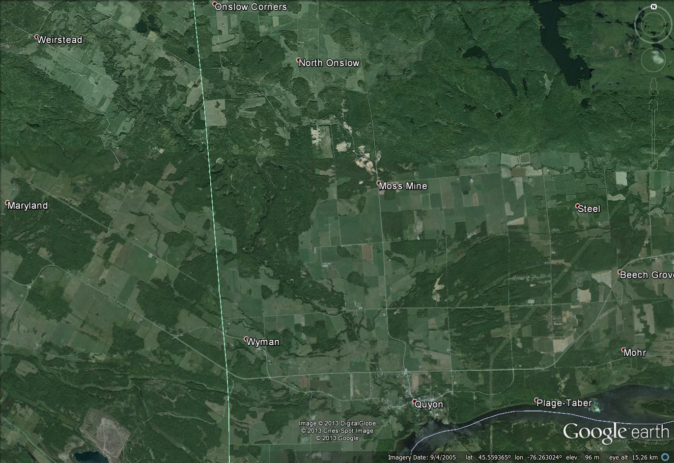
![]() A very interesting new paper, Brooks (2013), has just been published online in Quaternary Research, examining a massive landslide deposit and scar in the Quyon Valley in SW Quebec, Canada. The paper examines a huge, ancient landslide on the flanks of the Quyon River. The landslide, which is genuinely enormous – the surface area of the source is about 28 square kilometres! – occurred in sensitive glaciomarine sediments (these are the deposits that are sometimes known as quick clays). The weakness of these materials means that landslides can occur at very low shear surface angles (see this previous examples here and here, and of course the famous Rissa Video), which accounts for the huge surface area of the slide. However, these low surface angles also mean that the landslide scar is extremely difficult to see, even on imagery. The Google Earth image below shows the landslide scar, which extends from Weirstead in the northwest all the way to the river at Quyon in the southeast:
A very interesting new paper, Brooks (2013), has just been published online in Quaternary Research, examining a massive landslide deposit and scar in the Quyon Valley in SW Quebec, Canada. The paper examines a huge, ancient landslide on the flanks of the Quyon River. The landslide, which is genuinely enormous – the surface area of the source is about 28 square kilometres! – occurred in sensitive glaciomarine sediments (these are the deposits that are sometimes known as quick clays). The weakness of these materials means that landslides can occur at very low shear surface angles (see this previous examples here and here, and of course the famous Rissa Video), which accounts for the huge surface area of the slide. However, these low surface angles also mean that the landslide scar is extremely difficult to see, even on imagery. The Google Earth image below shows the landslide scar, which extends from Weirstead in the northwest all the way to the river at Quyon in the southeast:
..
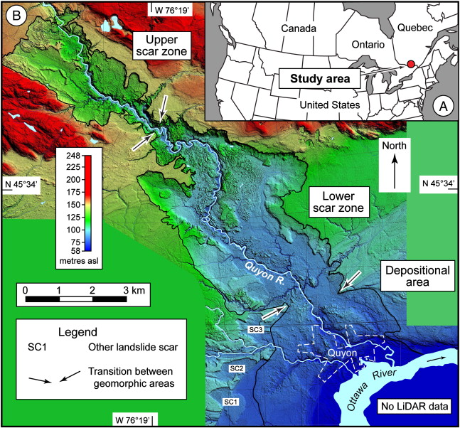
In fact the landslide only becomes clear when you look at the Lidar image in the paper – this is Figure 1 of Brooks (2013):
..
This landslide scar was first mapped by Wilson (1924), who noted that it is 12.8 km long and up to 4.8 km wide. Brooks notes that the depth ranges from 18 to 45 m; assuming an average depth of 25 m the volume would be about 700 million cubic metres (the paper itself suggests about 600 million cubic metres) – i.e. this is a very large landslide. One of the impressive aspects of this piece if work is that the landslide has been mapped and investigated in detail – this is far from trivial in such an enormous landslide in difficult terrain. The mapping clearly indicates that this occurred as a single, very large event, and there is evidence from terraces in the river valley that it created a landslide dam.
In the study, the landslide has been dated with 19 radiocarbon samples, mostly consisting of pieces of wood under or within the landslide mass, although six are from two areas of wetlands that formed after the landslide was deposited (and hence give younger ages). The eleven samples that represent the landslide itself show remarkable consistency, yielding a date of about 1020 cal yr BP (you can roughly take that as meaning the landslide occurred 1020 years before 1950). This of course raises an interesting question – what is the likely trigger of such a landslide? Interestingly, nine other landslides in the Ottawa Valley area have also been dated, all of which show very similar dates. Thus, it appears that about 1100 years ago there was a short period of multiple landslides in this area. A simple explanation would be that there was a single very large rainfall event that triggered all of the landslides, but in fact very large landslides in sensitive clays are generally not triggered by precipitation events. Thus, the author hypothesizes that the common trigger event was a large earthquake at that time. The paper suggests that the magnitude would have needed to have been about Mw=6.1, based on the area affected by known landslides.
Being able to identify large palaeo-earthquakes from landslide data has been something that has been on the agenda for a while now, but few studies have succeeded to date. Whilst this study has not definitively linked the landslides to a seismic event, this does seem to be the most likely explanation. Thus, it is a very useful and interesting contribution.
Reference
Brooks, G.R. (2013). A massive sensitive clay landslide, Quyon Valley, southwestern Quebec, Canada, and evidence for a paleoearthquake triggering mechanism Quaterrnary Research DOI: 10.1016/j.yqres.2013.07.008
Wilson, M.E. (1924). Arnprior–Quyon and Maniwaki areas Ontario and Quebec. Geological Survey of Canada, Memoir, 136.
 Dave Petley is the Vice-Chancellor of the University of Hull in the United Kingdom. His blog provides commentary and analysis of landslide events occurring worldwide, including the landslides themselves, latest research, and conferences and meetings.