
28 August 2013
A GNS Science report into the fatal landslide in June at Otuwhero Inlet in New Zealand
Posted by Dave Petley
Between 15th and 17th June this year exceptionally heavy rainfall in the Tasman District of New Zealand triggered large numbers of landslides in the Motueka area. One of these landslides, at Otuwhero Inlet, destroyed a house, killing the sole occupant. GNS Science, via the Geonet site, have released a report (Page 2013) into this landslide, as well as other landslides triggered by that rainfall event. The report makes very interesting reading.
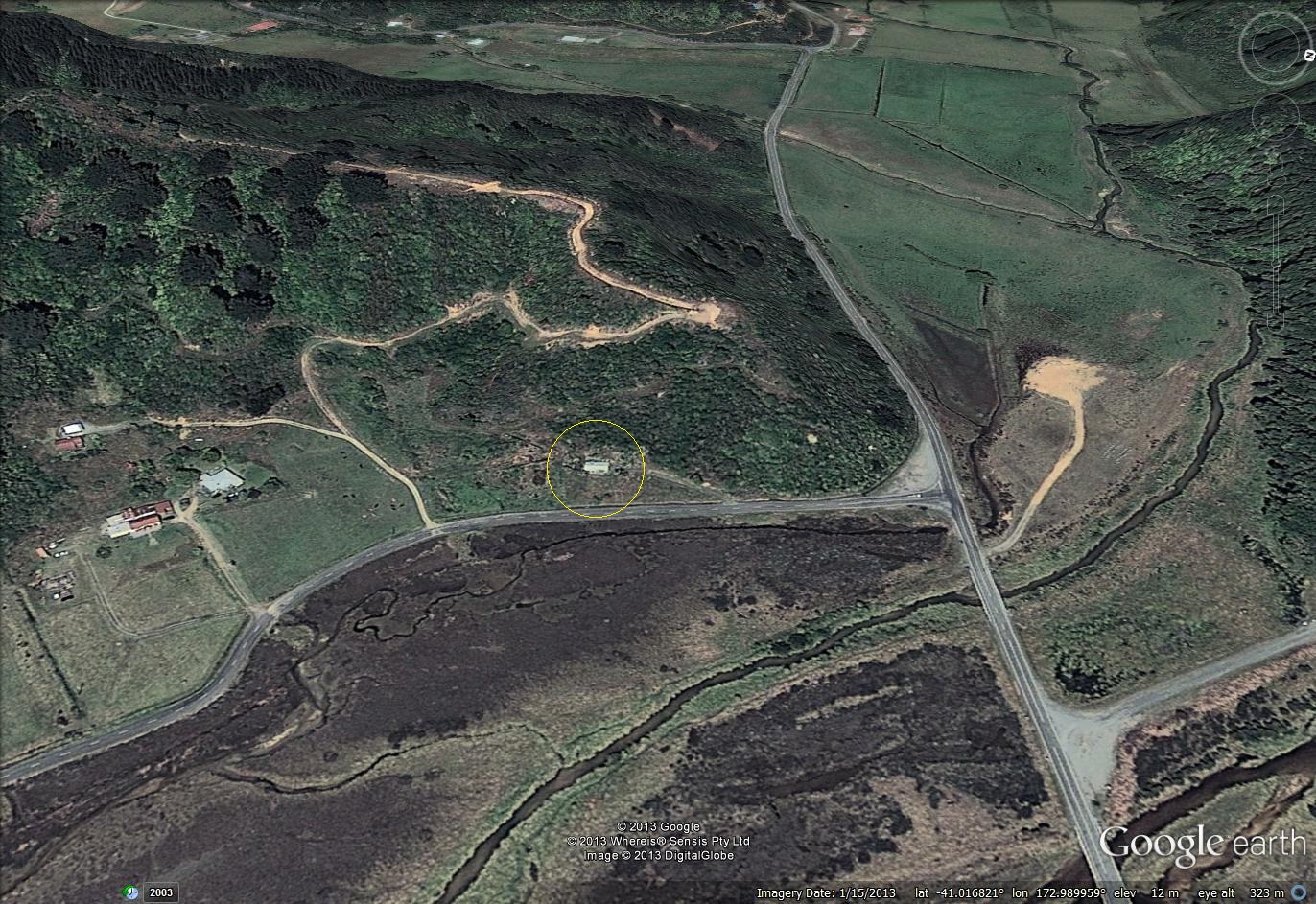
The location of the landslide is shown below in a Google Earth oblique image. If you want to take a look it is at -41.017, 172.990. The image was collected in January 2013; I have circled the house that was struck by the landslide:
..
The photo below, from the GNS report, shows the landslide and the destroyed house:

GNS Science / Nelson Mail photo of the landslide at Otuwhero Inlet
..
There are a few really interesting things to note here. First, the crown of the landslide coincides with a track – this road is also evident on the Google Earth image above. Second, there is another (old) track running across the mid-point of the landslide. And third, the house has not been buried but rather has been pushed ahead of the landslide, and it has collapsed.
The GNS Science report provides an analysis of the rainfall at the time of the landslide. The nearest rain gauge, which is uncalibrated, has a 48 hour rainfall total of 336 mm, an impressively high value. It unsurprising that landslides occurred under these conditions. In terms of the landslide itself, the following are the key points from the report (although I’d recommend reading it properly):
- The house was built on an old landslide deposit, which pre-dates the 1952 aerial survey. The single best indicator of the likelihood of a landslide at a location is the existence of earlier landslide deposits at that location.
- Clearly with the crown of the landslide being located at the edge of the track, the latter is of great importance. The investigation team found that the track is well-maintained and has good drainage, suggesting that water management was not the cause of the landslide. However,during maintenance of the track material had been dumped on the downslope side of the roadway. The report suggests that this happened between 2006 and 2010. Figure 21 from the report, shown below, suggests that these deposits were key to the landslide. In the background is the crown of the landslide scarp; in the foreground is some of this spoil material on the track edge. Clearly the landslide has failed through the spoil, which shows signs of tension cracking. The implication is that this spoil changed the stress state of the slope and its drainage properties, enhancing the likelihood of a landslide. Of course this material is weak, especially when saturated, which can allow the landslide to be both fast and mobile:
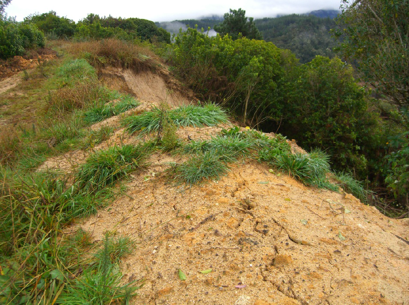
Figure 21 of the GNS Science report showing the spoil dumped at the margin of the track
…
- Nonetheless, this is a small landslide, so it is interesting to know why it killed the woman within the house. Clearly the structure was constructed at a location that was inappropriate in view of the landslide risk. The key element here is that the house was small (about 4 m wide and 11 m long) and constructed from very lightweight material (wall cladding of pressed metal and a corrugated iron roof). As the image below (from the GNS Science report) shows, the landslide struck the rear of the house, which was pushed forward several metres and then collapsed. Debris entered the house; the victim had to be dug out from the landslide material. Thus, it is likely that a key contributing factor may have been the lightweight structure – a more substantive building may have withstood the landslide without collapsing.
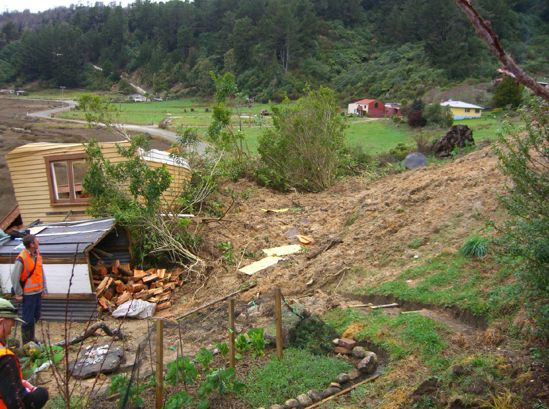
Figure 8 of the GNS Science report showing the collapsed house and the piled up debris from the landslide
…
Overall this is an excellent report that provides a very interesting insight into the factors that lie behind this tragedy.
Reference
Page, M. J. 2013. Landslides and debris flows caused by the 15-17 June 2013 rain storm in the Marahua-Motuea area, and the fatal landslide at Otuwhero Inlet. GNS Science Report 2013/44.
 Dave Petley is the Vice-Chancellor of the University of Hull in the United Kingdom. His blog provides commentary and analysis of landslide events occurring worldwide, including the landslides themselves, latest research, and conferences and meetings.