
26 January 2011
Before and after: high resolution images of the Brazil landslides
Posted by Dave Petley
Thanks to AAM for pointing this out as a comment in yesterday’s Brazil landslide post. The private Geoeye satellite has obtained a very high resolution image of the an area affected by the recent landslides in Brazil. The image, which was collected on 20th January, can be viewed and downloaded here.
The complete image is shown below (obviously compressed here):
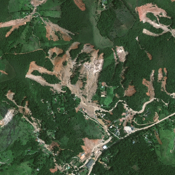
Satellite image by GeoEye
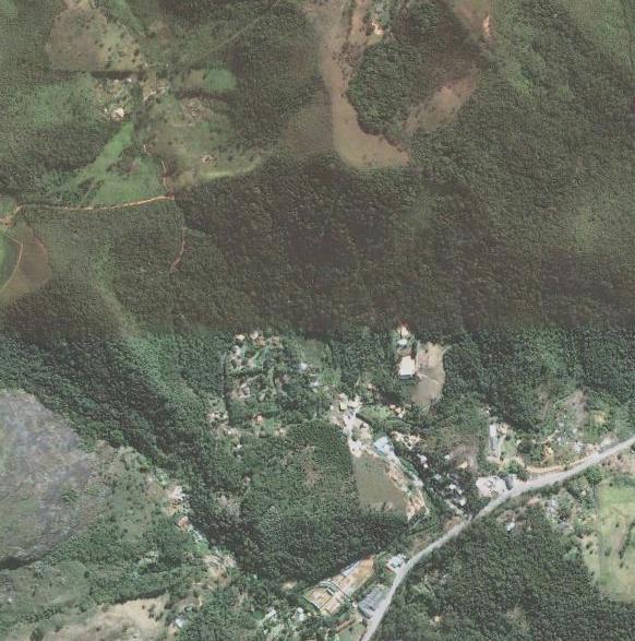
Helpfully, Google Earth also has a Geoeye image of the same area collected in 2008:
However, what has happened here becomes much clearer when the image above is draped over the (somewhat rudimentary but still useful) Google Earth terrain model to create a 3D view:

There are several interesting elements to this, of which I will highlight a few. I invite others to use the comments to make their own observations.
1. The area has a mixture of forest and cleared land – and of course we always think that forestry (or lack thereof) plays a key role in determining landslide occurrence in heavy rainfall. However, I don’t see much evidence from the above that the woodland has played a key role in determining the landslide locations. Some cleared areas have failed, but so have some wooded areas as well, and vice-versa.
2. The key factor in determining landslide location seems to be slope gradient, with the landslides notably picking out the steeper slope areas, and in those areas the landslides extend to the ridges.
3. In several cases the failures the landslides appear to extend down to bedrock – and indeed the areas with thin soil cover before the landslides are visible in the vegetation patterns. In some cases it appears that the landslides have preferentially picked out these areas.
4. The settlements are very poorly located in terms of risk from these landslides. Note that these are not urban areas, but rural communities. In particular, the area of houses in the centre of the image above has been decimated by the slides that have occurred in the bowl-shaped topography above them. The horror of being in such a location during these landslides is unimaginable.
5. In the bowl-shaped area above much of the debris appears to have been removed, with two different watercourses being visible (one heading to the east, one to the south, then southwest). It is unsurprising that the watercourses have had so many debris flows.
Other thoughts and comments?
 Dave Petley is the Vice-Chancellor of the University of Hull in the United Kingdom. His blog provides commentary and analysis of landslide events occurring worldwide, including the landslides themselves, latest research, and conferences and meetings.
[…] This post was mentioned on Twitter by Chris Rowan, Daves Landslide Blog. Daves Landslide Blog said: Before and after: high resolution images of the Brazil landslides: Geoeye has now collected a high quality image… http://bit.ly/ekm6gx […]
It does look like some of the landslides might have happened in areas of undisturbed Mata Atlantica (Atlantic Forest), in addition to the areas where the forest was previously cut down and replaced with other vegetation.
Rio de Janeiro state and the city is famous for its extremely steep mountains with exposed smooth granite surfaces. There may be somewhat less steep slopes that have forest cover but only with a very thin soil that can easily slide off.
[…] High resolution before and after images of the Brazil landslides at the Landslide Blog https://blogs.agu.org/landslideblog/2011/01/26/before-and-after-high-resolution-images-of-the-brazil-… […]
Great post! Absolutely amazing pictures of the landslides can also be found at the Boston Big Picture: http://www.boston.com/bigpicture/2011/01/landslides_in_brazil.html. Image 27 is great for understanding the extend of the slides.
Nice job. By coincidence I did something similar (same day! 🙂 ) while we, here at INPE, were waiting for International Charter Call 351 images, check it out: http://twitpic.com/3tmn98 Also, a video and some example charts, official products, for Região Serrana disaster are available here http://www.inpe.br/noticias/noticia.php?Cod_Noticia=2439
[…] well as it happens" on freebys;) http://freegoogleearth.blogspot.comPowered by Yahoo! AnswersJohn asks…How do I log into google earth plus??my google page does not have a 'log in' maybe I am …s not have a 'log in' maybe I am doing something wrong, can ya hep me out??admin answers:Download: […]
[…] months of the year, triggering significant numbers of landslides. In January 2011 for example heavy rainfall in Rio de Janeiro killed 903 people, including 424 people in Nova Friburgo and 378 people in Teresópolis. The […]