
8 July 2008
Rockfalls from the Eiger
Posted by Dave Petley
In 2006 Hans Rudolf Keusen of Geotest raised concerns that a large pillar on the Eiger mountain in Switzerland had become unstable. Over the next few weeks the pillar did indeed progressively fail, providing some amazing images of a large rockfall in action (Fig 1):
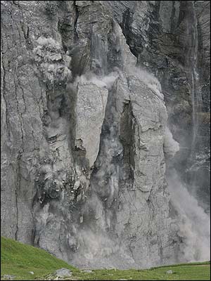 Figure 1: AP image entitled: On July 13, 2006, masses of rock fell down from Eiger, near Grindelwald. The event came after days of warnings from scientists regarding rock loosened by melting glacial ice.
Yesterday, Hans Rudolf Keusen again warned of the dangers of summer rockfalls on the Eiger. Once again, rockfalls have been occurring on the northwest side of the mountain, associated with the melting of the Lower Grindelwald glacier, which has left the flank of the mountain unsupported. The concern this time is that a rockfall could fall into a small lake at the toe of the slope, displacing “up to 900,000 cubic metres of water…in the space of several hours” (see here). Fortunately, monitoring systems are in place to detect any sudden rises in lake level, so a warning should be available.
The Swiss Glacier Monitoring Network has a rather nice image of the glacier in question (Fig. 2):
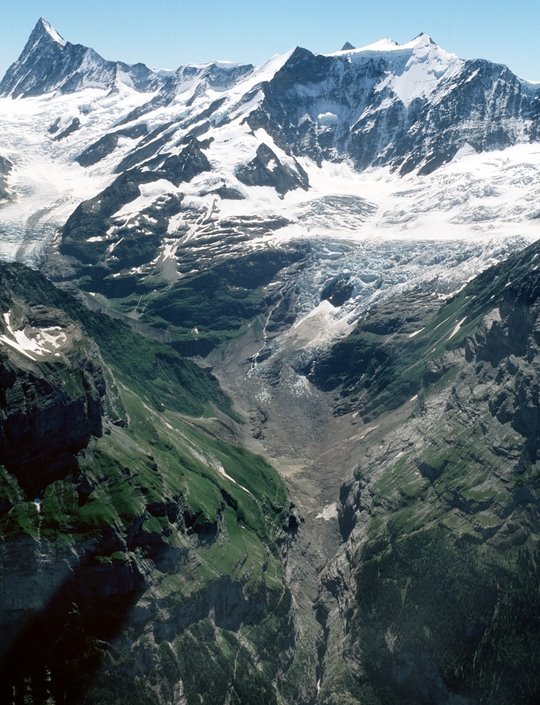 Fig 2. Swiss Glacier Monitoring Network image of the Lower Grindelwald glacier, showing the debuttressed slopes above the moraines deposited by the glacier as it retreated.
The magnitude of the problem is well-illustrated by annual monitoring data that they have collected on the length of the glacier (Fig. 3). This shows the dramatic retreat of the glacier over a century, in which more than a kilometre has been lost. Unfortunately the data only extends to 1983, but the current average retreat rate is about 20 m per year.
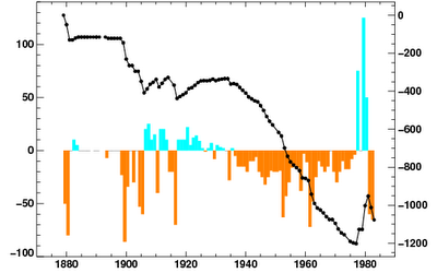 Fig 3. Swiss Glacier Monitoring Network graph of the length of the Lower Grindelwald glacier in the period 1879 to 1983.
 Dave Petley is the Vice-Chancellor of the University of Hull in the United Kingdom. His blog provides commentary and analysis of landslide events occurring worldwide, including the landslides themselves, latest research, and conferences and meetings.