
17 February 2015
Earthquake faults identified in surge of Oklahoma quakes
By Nanci Bompey
New research has revealed the faults associated with more than 3,600 earthquakes that have been recorded in Oklahoma since 2009. The study also finds that recently reactivated ancient faults in the center of the state could generate higher-magnitude and more destructive earthquakes than the region has experienced since earthquake activity picked up there five years ago.
Previous research in the region had shown that ancient faults that hadn’t produced earthquakes in centuries are most likely being reactivated by oil and gas activity in the area. The new study finds that the locations and sizes of the faults suggest that they are capable of letting loose heftier quakes capable of doing more harm than the typical low-magnitude earthquakes that have been observed in Oklahoma over the past five years.
These reawakened faults in central Oklahoma could produce magnitude 5 and 6 earthquakes, similar to the 5.6-magnitude earthquake that struck near the town of Prague in 2011, according to the new study. The Prague earthquake, that was part of a swarm of moderate earthquakes, was one of the largest in Oklahoma history, causing damage to buildings and roads. The rate of magnitude 3 or larger earthquakes in north-central Oklahoma is nearly 300 times higher than it was in previous decades, the researchers also found.
“By identifying the faults, we are providing some guidance about where major earthquakes can happen,” said Dan McNamara, a research geophysicist at the U.S. Geological Survey National Earthquake Information Center in Golden, Colorado, and lead author of the new study accepted for publication in Geophysical Research Letters, a journal of the American Geophysical Union.
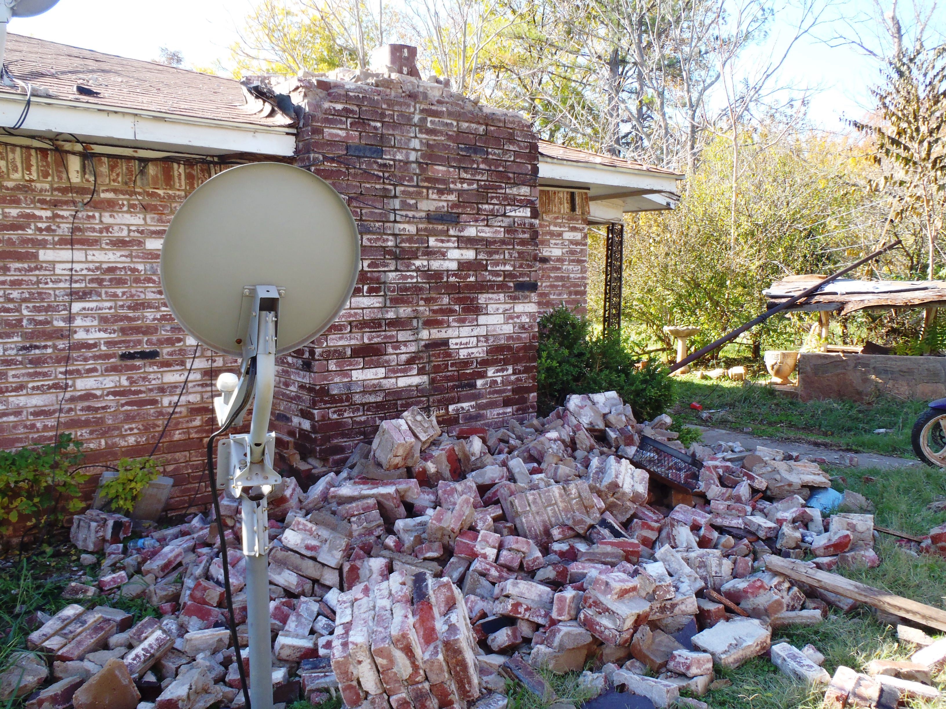
A magnitude 5.6 earthquake in November 2011 damaged this central Oklahoma house. Credit: U.S. Geological Survey/photo by Brian Sherrod
The findings by McNamara and his colleagues are a key element that will be used to develop a new earthquake-hazard map for Oklahoma that USGS is planning to issue later this year, the researchers said. Including these results marks the first time the state’s earthquake hazard maps will include induced, or non-naturally occurring, earthquakes, they added.
Current hazard maps, which show the likelihood of an area experiencing earthquake shaking of various intensities, do not take into account induced seismicity and could be underestimating the earthquake hazard for Oklahoma and other states, McNamara explained. Augmenting these maps with information about the types, location, size, depth, magnitude and frequency of the reactivated faults could help officials provide guidance to the oil and gas industry and aid in adapting building codes to ensure that structures can withstand more damaging earthquakes, he added.
The new study does not seek to link earthquakes in Oklahoma to oil and gas activity, but to inform engineers, architects and regulators about the increased earthquake risk in the state, the study says.
“The goal is to determine the changing earthquake hazard for existing buildings and infrastructure,” McNamara said.
To comprehensively assess the earthquake risk in Oklahoma, McNamara and his colleagues examined data collected by seismometers that have been deployed in central Oklahoma by USGS, the Oklahoma Geological Survey, the University of Oklahoma and other groups. From this data, they compiled a catalog of 3,639 earthquakes recorded in central Oklahoma from late 2009 through 2014. It’s the first comprehensive look at seismicity in the state, McNamara said.
The study’s authors then analyzed the data to identify clusters of earthquakes. These clusters helped them better pinpoint where the earthquakes occurred, which led them to the underground faults that run through those locations, McNamara said. The scientists could then determine the length, depth and style of faulting present in those ancient, reactivated fault systems.
The reactivated faults are part of two fault-ridden areas: the Wilzetta fault system, a complex fault zone about 200 kilometers (124 miles) long near Prague that was restarted during the 2011 earthquake, and the Nemaha fault system that runs nearly the entire length of the state, passing through Oklahoma City.
The study’s authors found that most faults in the reawakened systems are oriented in such a way that makes them more susceptible to rupture. The earthquakes that have occurred are shallow, which raises the potential for even small ones to cause damage. A substantial number of faults span relatively long distances, meaning they are capable of producing bigger earthquakes (magnitude 5 or 6). In a few cases, earthquakes emanate from well-known faults that have the potential to produce larger earthquakes, the study notes.
“Together these findings indicate a higher level of potential earthquake hazard in central Oklahoma,” the study says. The earthquake hazard today surpasses what it was five years ago, according to the new research.
Shemin Ge, a hydrogeologist at the University of Colorado – Boulder, who didn’t participate in the research, said the study’s broad and detailed picture of earthquakes in Oklahoma could help scientists further clarify if earthquakes in the region are linked to oil and gas activity. A better understanding of faults that are being reactivated could help scientists examine what happens when wastewater from such activity is injected underground, she added — in particular whether changes in pressure that builds up in pores within underground rock could be weakening faults and triggering earthquakes.
– Nanci Bompey, AGU public information specialist/writer