
6 February 2017
New climate index based on atmospheric pressure produces more accurate predictions of storm wave conditions
Posted by Nanci Bompey
By Alan Williams
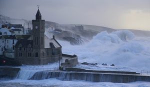
This image shows huge waves battering the Cornish coast at Porthleven on 5 February 2014.
Credit: Matt Clark, Met Office
A method based on the north-south atmospheric pressure gradient along the Atlantic coast of Europe could lead to enhanced forecasting of extreme wave conditions and increased preparedness within coastal communities, a new study suggests.
Researchers from the University of Plymouth, the Centre National de la Récherche Scientifique, l’Université de Bordeaux and l’Institut Universitaire Européen de la Mer have developed a new climate index, termed the West Europe Pressure Anomaly (WEPA).
It is based on the atmospheric pressure difference between the Canary Islands and Ireland, and is very strongly linked to the winter wave variability along most of the west coast of Europe.
Initial tests have shown it significantly outscores existing functions, particularly an index called the North Atlantic Oscillation (NAO), which has long been known to affect climate variability in the Northern Hemisphere and wave climate arriving at the coasts of the UK, Portugal, France and Ireland.
The NAO index is computed based on the difference in atmospheric pressure between the well-known ‘Azores High’ and ‘Icelandic Low’, and more energetic wave conditions are generally associated with a large atmospheric pressure difference.
However, during the 2013/14 winter, when repeated storms battered Europe’s Atlantic coastline (and when the UK was impacted by extensive river flooding), the value for the NAO was far from exceptional, despite the fact that in terms of wave conditions it was the most energetic winter in almost seven decades.
A study of the new tool has been accepted for publication in Geophysical Research Letters, a journal of the American Geophysical Union, with researchers using modeled wave and weather data to generate their findings.
Gerd Masselink, Professor of Coastal Geomorphology at the University of Plymouth, said:
“WEPA is the most relevant index to explain storm wave variability, both spatially and temporally, along the Atlantic coast of Europe. It is critical to our understanding of coastal hazards across western Europe, including in the UK. Further testing should be carried out to assess whether it is also correlated to other climate factors and consequences, such as rainfall and river flooding.”
Sea-level rise is seen by many as the major threat to our coast, and previous studies led by the University of Plymouth have shown that extreme wave conditions can induce dramatic coastal erosion that may take many years for the coast to recover.
Being able to forecast such extreme winters is a key issue for coastal management and the climate indicator reported in this study can be an extremely useful tool for making such predictions.
Dr Tim Scott, Lecturer in Ocean Exploration, added:
“The real value of climate indices such as WEPA is that if climate modellers can predict how such indices may change in the future due to climate change, we will have a means to indirectly assess the impact of climate change on storminess. Even if we can predict the value of WEPA several months year ahead, this would already be of great use to coastal managers and help them with preparing for the winter.”
— Alan Williams is a media and communications officer at Plymouth University. This post originally appeared on the Plymouth University website.