
11 August 2017
“Heartbeats” of an underwater volcano’s eruption imaged by ultrasounds (plus VIDEO)
Posted by mjepsen
Above, footage of the eruptive plume taken aboard the deck of the research vessel. Below, acoustic images depicting the underwater eruption. Credit: Marine geologists of the Geological Survey of Spain (IGME)
By Madeleine Jepsen
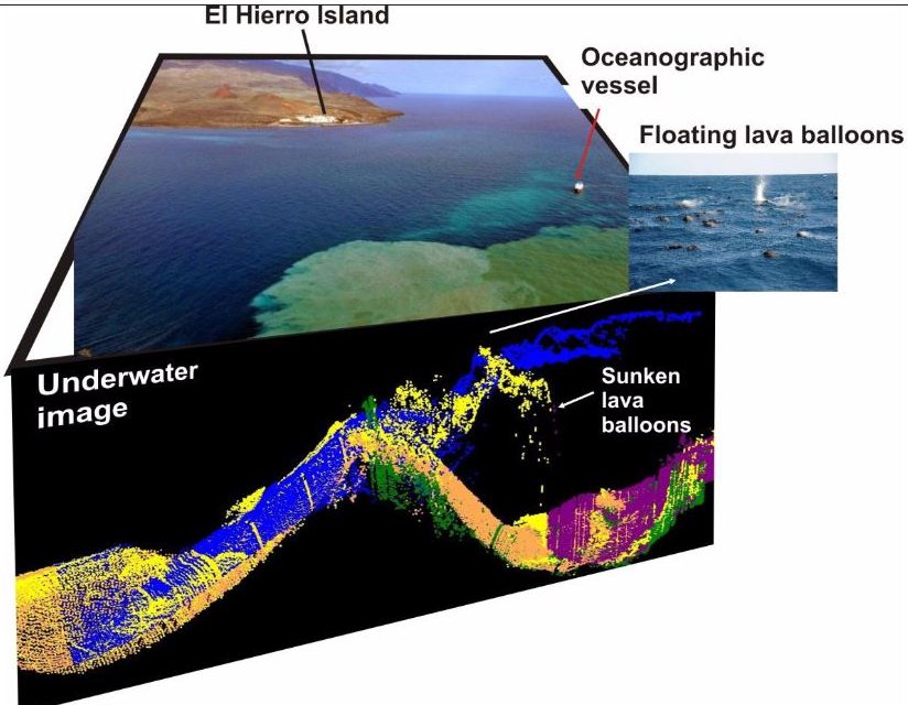
Using acoustic footage of a volcanic eruption and images taken by a remotely operated vehicle (ROV), scientists have documented an underwater volcano’s eruption off the coast of El Hierro, the smallest of the Canary Islands. Though underwater volcanoes are common, footage of their eruptions is rare because of the dangers of getting close enough for observations.
The high-resolution acoustic footage, which shows bubbles of steam, ash, and lava balloons, will help scientists better understand the different stages of an underwater volcano’s eruption, according to Luis Somoza, the lead researcher of the study and a marine geologist from the Geological Survey of Spain.
The scientific study, which provides details about the eruption process, is published in Geochemistry, Geophysics, Geosystems, a journal of the American Geophysical Union.
The new research also provides a protocol for future scientific monitoring of eruptions in the Canary Islands or in other similar volcanic hotspots like the Hawaiian Islands, according to the study’s authors.
Characterizing a volcanic eruption
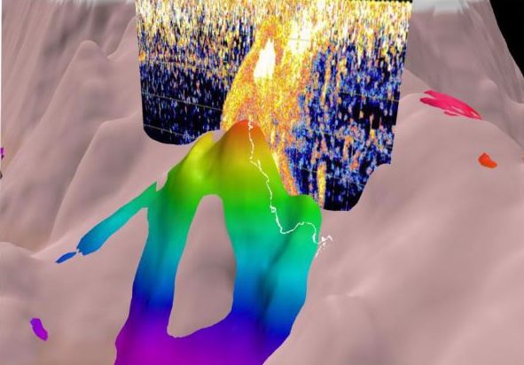
This image merges the acoustic image of the underwater plume with the topography of the volcano. Bright spots on the right of the image are lava balloons sinking to the base of the volcano. Credit: Marine geologists of the Geological Survey of Spain (IGME)
Three-dimensional images constructed from the data illustrate how the summit of the volcano called “Tagoro” grew 286 meters (938 feet) from the seafloor between October 2011 and March 2012. The eruption consisted of two main growth phases of the volcano edifice separated by a collapse in the rock, which generated numerous avalanches and lava deposits 500-1,400 meters (1,640-4,593 feet) deep in the water.
Somoza said the opportunity for this investigation arose purely by chance, since the fully equipped vessel was near the Canary Islands for another project when the undersea volcano began to erupt.
“The commission for management of volcanic risk in the Canary Islands (PEVOLCA), called us urgently to head to the eruption zone in order to determine the depth of the summit of the new volcano, and whether another eruptive vent might have been opened near the island due to the numerous earthquakes and volcanic tremors that had occurred in the north part of the island,” Somoza said.
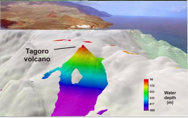
A 3D bathymetry image of Tagoro volcano combined with an aerial photo of La Testinga, the fishing village only one nautical mile from the eruption. Credit: Marine geologists of the Geological Survey of Spain (IGME)
The acoustic imaging footage shows plumes of gas bubbles from the eruption, underwater ash particles and buoyant volcanic rocks called lava balloons. The lava balloons, as big as 2 meters (7 feet) in diameter, are bubbles of molten lava contained in a thin shell of cooled lava. Over the course of the eruption, the steaming lava balloons rose to the surface of the ocean, then cooled down and sank back to the ocean floor, where they burst open and spilled the lava on the seafloor.
In the final stage of the eruption, structures called “hornitos” (little ovens) formed at the volcano’s summit. The study’s authors compared the hornito structures, 5-10 meters (16-33
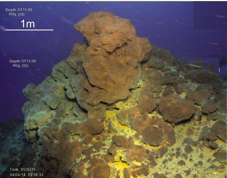
Footage of an “hornito” at the summit of the volcano, which formed during the final phase of the eruption. Credit: Marine geologists of the Geological Survey of Spain (IGME)
feet) tall, to the grooves and ridges of a castle tower. According to the researchers, these pyramid-like structures were built from the volcanic emissions and hydrothermal fluids which occurred in the end phase of the eruption. Contrary to predictions, the formation of the hornitos was “tranquil,” and there were not violent explosions, Somoza said.
Two years later, while the hydrothermal vents were still emitting carbon dioxide, Somoza and the team of researchers used an ROV to study the rock formations produced in the eruption. At that time, the volcano’s summit had become fully covered by a layer of orange-colored flakes and bacteria blooms, which were triggered by the iron emitted from the hydrothermal vents. Conger eels and shrimp also colonized the vents, and can be seen in the ROV footage.
— Madeleine Jepsen is a science writing intern at AGU.