
19 September 2016
New study “reels in” data on Utah’s winter ozone problem
Posted by Lauren Lipuma
Novel research method allows precise tracking of ozone production rates
By Theo Stein
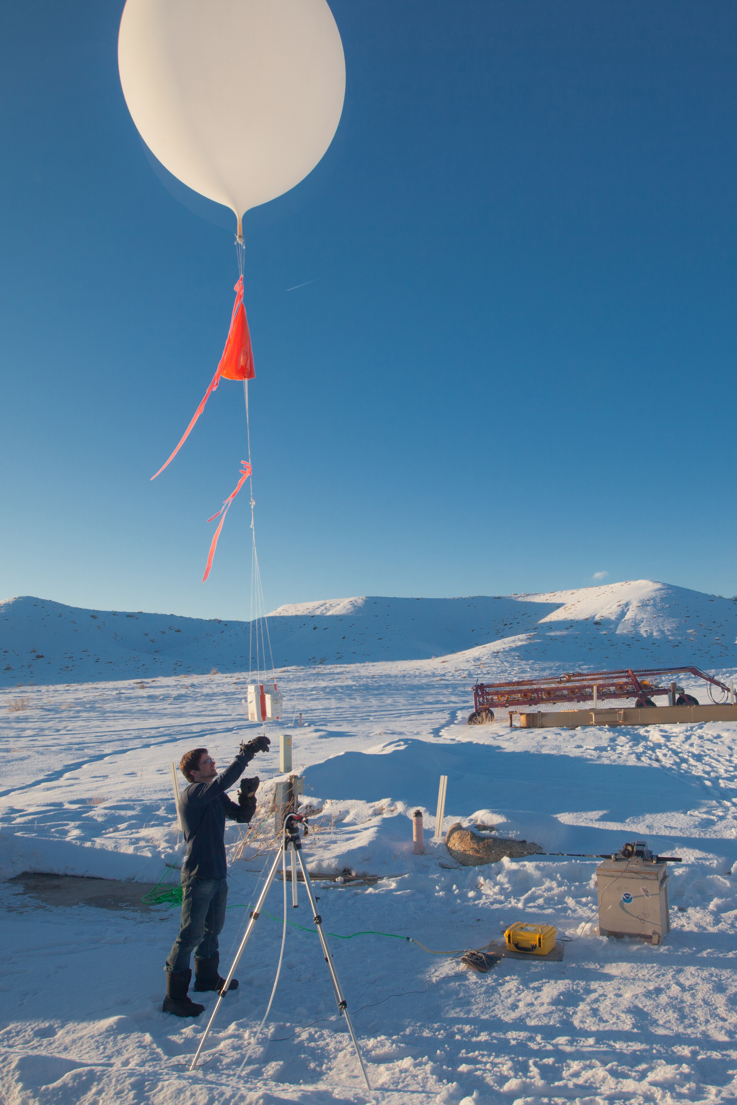
Chance Sterling, a NOAA researcher studying ozone formation in Utah’s Uinta Basin, samples the atmosphere using an innovative, tethered weather balloon during the winter of 2013.
Credit: Patrick Cullis/NOAA-CIRES.
A deep sea fishing rod is probably not the first tool that comes to mind when thinking about how to study air pollution in a remote inland desert, but it’s the heart of a new system that has given scientists a minute-by-minute look at how quickly the sun can convert oil and gas emissions to harmful ground-level ozone.
Results from a new study using this method to examine the formation of ozone pollution in eastern Utah’s Uinta Basin has revealed just how quickly sun, snow and chemical vapors emitted by oil and gas facilities produce ozone levels that can be harmful to human health.
Data collected during field work in 2013 showed under proper conditions, ozone levels rose as much as 10 ppb per hour. Over the course of a week, ozone levels surged from a background of 40 parts per billion to 165 ppb – more than double the federal ozone standard of 75 ppb, according to the new study published in the Journal of Geophysical Research-Atmospheres, a journal of the American Geophysical Union.
“This study ties up a lot of loose ends from our earlier work,” said Russ Schnell, deputy director of the Global Monitoring Division at NOAA’s Earth System Research Laboratory in Boulder, Colorado and lead author of the study. “What’s new is the method we developed to conduct this study. We can now see how ozone is being formed in real time over the space of minutes and how it’s distributed in the air column.”
Dubbed the “tethersonde,” the sampling system mates a deep sea fishing rod to a standard weather balloon carrying an ozone-measuring instrument and radio transmitter. Driven by an electric motor and controlled by custom software, the rig allows researchers to raise and lower the balloon to specific altitudes at precise rates.
In addition to providing better data, the system also saves researchers money, Schnell said. A single ozone profile obtained with a traditional weather balloon costs between $1,200 and $1,500 because the balloon and instrumentation are rarely recovered.
“Now we can do 100 profiles for the same cost,” Schnell said. “We can cycle a balloon through an up-and-down profile in less than 30 minutes, which gives us the ability to understand ozone formation over time and space at a high resolution. We can repeat the cycle up to 40 times in a day, then test the calibration of the instrument at the end of the day.”
Ozone pollution is typically a summertime phenomenon associated with large, urban areas. The Green River Basin in Wyoming, another major energy field, also suffers from high winter ozone levels.

A closeup depiction of the control unit for a “tethersonde” – an instrumented weather balloon tethered to a fishing rod driven by a computer-controlled electric motor that NOAA researchers used to study the rate of ozone formation in Utah’s remote Uinta Basin in 2013.
Credit: NOAA.
High in the stratosphere, ozone protects life on Earth from the sun’s harmful ultraviolet rays. When elevated levels of ozone are trapped near the ground, it can impair breathing and aggravate lung diseases such as asthma and emphysema. The Environmental Protection Agency recommends that people, especially those in sensitive groups — children, the elderly, and anyone with pre-existing respiratory conditions — limit time outdoors during bad ozone days.
The new study showed while the center of the ozone production zone is the sparsely populated Uinta basin, high ozone levels did spread up the White River valley into the town of Rangely, Colorado, and into portions of Dinosaur National Monument in Utah. Researchers found that the ozone pollution was mainly caused by oil and gas development. A nearby power plant’s nitrogen dioxide emissions did not appear to contribute to the problem.
The study also confirmed the important role played by the reflection of sunlight off of snowpack in amplifying the chemical reactions that convert oil and gas facility emissions to ozone. A previous study in the Uinta Basin in the snow-free winter of 2012 found no episodes of elevated ozone.
The chemical drivers of winter ozone formation in the Uinta Basin differ greatly from summer ozone formation in urban areas.
—Theo Stein is a public affairs officer at NOAA in Boulder, Colorado. This post originally appeared on the NOAA research website.
What an ingenious idea. I want one of those!