
2 September 2016
A Tale of Atlin Ophiolite
Posted by Nanci Bompey
By Rebecca Fowler
This is the first in a series of dispatches from Rebecca Fowler, a science writer documenting the work of scientists conducting fieldwork at the Atlin ophiolite in British Columbia.
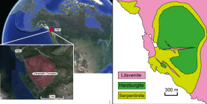
(Left) The location of the town Atlin and the Atlin ultramafic (or mantle rock) complex. A detailed geological map is shown in the right panel. (Right) The currently available geologic map of the Atlin ultramafic complex. The green patch in the middle of the map corresponds to the ultramafic complex in the left map (modified by Tominaga and Beinlich from Ash and Arksey, 1990).
In two days I arrive in Atlin, British Columbia, which lies just south of the Yukon Territory. Google tells me Atlin contains a tiny lakeside town of around 450 people, spectacular mountain scenery and a relatively uncommon geologic formation: An ophiolite, a slice of the Earth’s oceanic crust and underlying mantle now exposed on land through a glitch in the normal subduction process. Instead of the ocean crust diving beneath the continental crust when plates converge, some is obducted, or pushed up, on top of it. Ophiolites are found around the world in places like Oman, Cyprus and Norway; each offers the unusual experience of being able to walk right up to the ocean crust to study its structure and composition.
Ophiolites are also of interest to Earth scientists because mantle rock can act as a natural carbon sequestration reservoir, meaning its minerals react with carbon dioxide from the atmosphere and permanently trap it in stone.
Among the scientists investigating the capability of mantle rock as a natural carbon sink are Masako Tominaga, a geophysicist at Texas A&M University in College Station and Andreas Beinlich, a geologist at Curtin University in Bentley, Australia. They’re leading a week of fieldwork from September 4-10 to study a portion of the Atlin ophiolite on the eastern side of Atlin Lake.
The rest of their field team consists of Ian Power, a geochemist and postdoc at the University of British Columbia, Estefania Ortiz, a first-year geology and geophysics masters student who works in Masako’s lab, and me. I’m a science writer and a recent transplant to College Station, where I met Masako. She’s keen on science communication and outreach, and I’m eager to join scientists in the field, so I quickly said yes when she invited me to join her for the Atlin fieldwork. We are a small team but, as is often the case in geoscience, we’re a diverse group—the five of us represent Japan, Germany, Canada, Mexico and the United States.
For this project, Masako and Andreas received funding from the National Science Foundation to develop a field-based monitoring technique to directly observe and track the carbonation process through its effects on the magnetic mineralogy and density of the rocks, and to gain a greater understanding of how this geochemical process works.
They’re primarily interested in the peridotite rock found in the mantle that’s now obducted on land as a part of the ophiolite sequence, and the chemical processes that occur during fluid circulation through the rock. One of these processes is carbonation, where carbon dioxide in fluids reacts with the serpentinized peridotite to form serpentinite, then soapstone and finally listvenite. Understanding the extent and rate of peridotite carbonation will shed light on a variety of Earth science processes, including the exchange of carbon between the atmosphere, hydrosphere (e.g., oceans, rivers, groundwater) and the Earth’s crust and interior, and the role that carbon plays in the evolution of the Earth.
The peridotite carbonation process has also been proposed as a permanent way to remove carbon dioxide from the atmosphere or large-scale emitters of carbon dioxide, such as fossil-fuel power plants, and sequester it underground. If the process can be sufficiently scaled up, it could be a viable method for the long-term storage of atmospheric carbon dioxide, which would help slow global warming.
Masako and Andreas hope that our September fieldwork will provide baseline information for other scientists studying carbon sequestration. To get to that point, our group must first travel from various parts of the world—Australia, Texas, Canada—to White Horse, in the Yukon, and then drive about three hours south to Atlin. During our five days in the field, we’ll take magnetic measurements, collect rock samples, make a geological field map of the area, and reconstruct 3D images of the outcrops using a photogrammetry approach (making measurements from photographs) to investigate the extent of peridotite carbonation in the area.
Thanks for hanging on for that geology lesson; visit this blog again for two posts from the field. We’ll also share photos from our fieldwork on the AGU’s Instagram account from September 4-10. Please follow along!
— Rebecca Fowler is a science writer who divides her time between freelance projects and communications for Columbia University’s Center for Climate and Life.