
3 June 2015
Rebuilding Sandbars in the Grand Canyon
Posted by mcadams
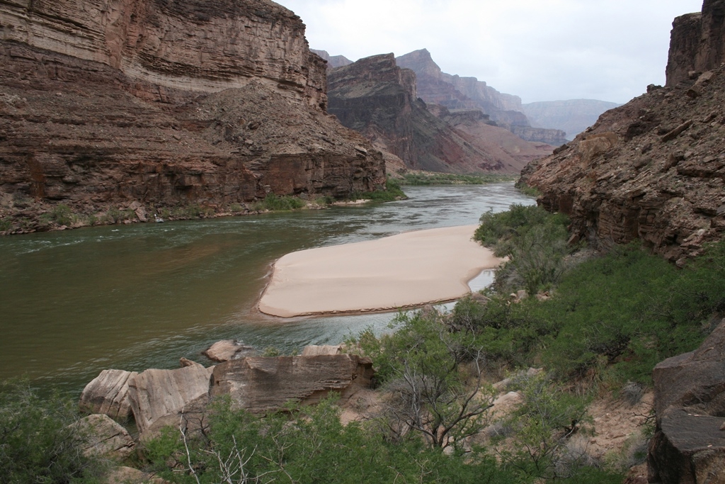
Sandbar on the Colorado River in Grand Canyon deposited by 2008 controlled flood. The river is flowing from left to right and the location is approximately 65 miles downstream from Lees Ferry, Arizona.
Credit: USGS
By Paul Grams and Jennifer LaVista
The Grand Canyon is a bit closer to how it was before one of the country’s largest dams was installed upstream. Three years of releasing water from Glen Canyon Dam to generate controlled floods has resulted in rebuilding sandbars in the Grand Canyon, according to a new USGS article published in Eos, the daily Earth and space science website published by the American Geophysical Union. These simulated floods redistribute sand and mud, which helps develop this critical feature.
Sandbars are an important part of the Colorado River ecosystem. They provide habitat for native and endangered fish, sand that supports vegetation and helps protect archeological sites, and the flat ground provides great camping spots under the stars.
“This study demonstrates the advantages of a robust science program dedicated to understanding the unique resources of the Grand Canyon,” said Principal Assistant Secretary for Water and Science Jennifer Gimbel. “These findings will help inform decisions that benefit the Grand Canyon, as well as the millions of Americans who rely on this treasured watershed for recreation, water and power.”
Preserving a National Treasure Through Science
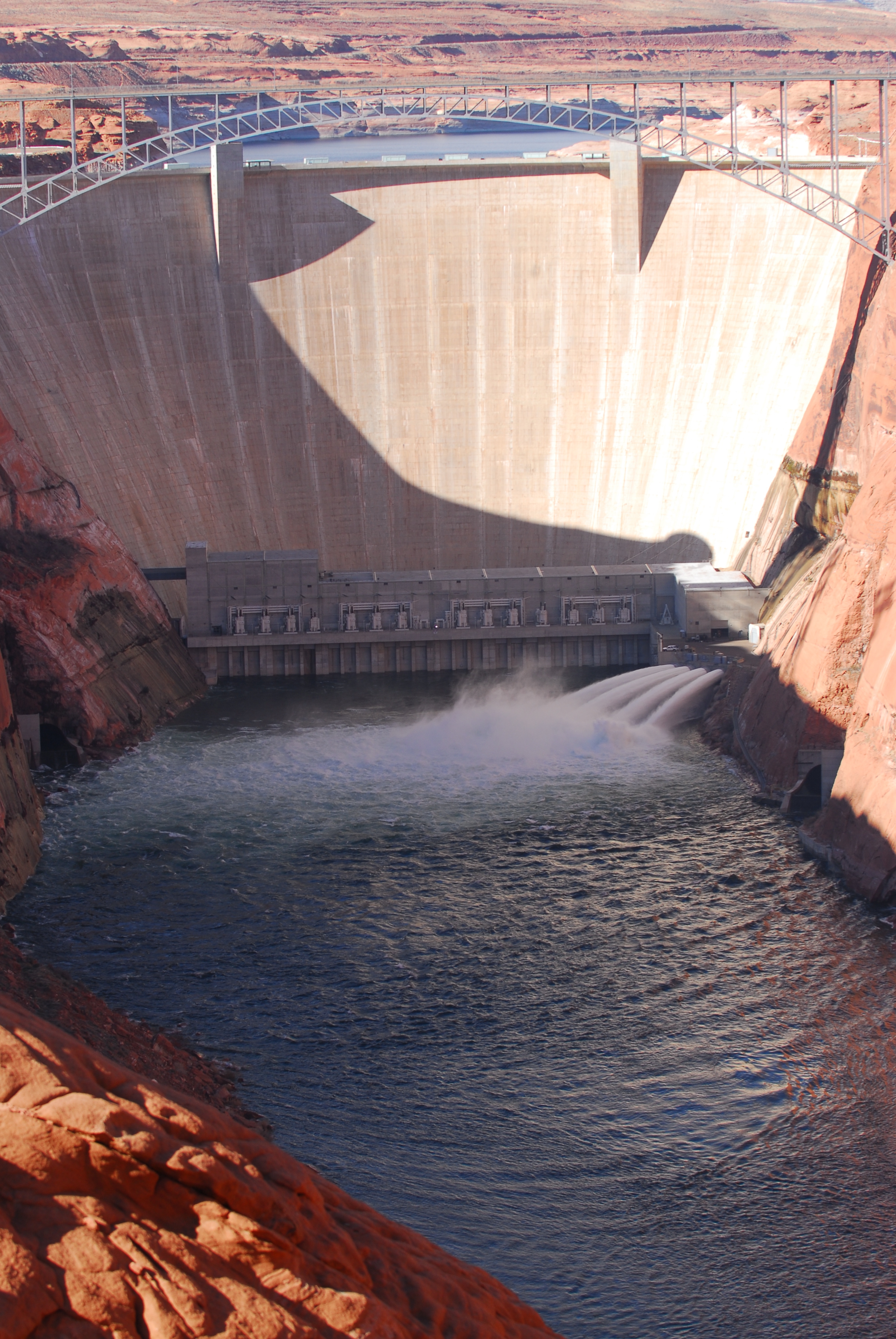
Glen Canyon Dam during a high flow experiment.
Credit: USGS
In 1963, the U.S. Department of the Interior’s Bureau of Reclamation (Reclamation) finished building Glen Canyon Dam on the Colorado River in northern Arizona, about 15 miles upstream from Grand Canyon National Park. The dam backed up about 186 miles of the Colorado River, creating Lake Powell, the nation’s second largest reservoir.
By 1974, scientists found that the downstream river’s sandbars were eroding because the reservoir trapped the fine sediment that replenished the deposits during annual floods. These sandbars are important structures for many kinds of life in and along the river.
Building on knowledge gained in earlier experimental flow releases (1996, 2004, 2008), in 2012, DOI adopted a “high-flow experiment” (HFE) protocol intended to help restore the environment by creating flood-like conditions below Glen Canyon Dam in order to rebuild sandbars that are important habitat and recreational resources. The HFE protocol is intended to improve understanding of how to better distribute sediment to conserve downstream environmental resources by allowing for multiple high-flow tests through 2020, while still meeting needs for water delivery and hydropower generation.
Three years into HFE, the releases appear to be achieving the desired effect. Many sandbars have increased in size following each controlled flood, and the cumulative results of the first three releases suggest that sandbar declines may be reversed if controlled floods can be implemented frequently enough when sediment conditions are favorable.
This work, which includes planning and implementing controlled floods and ongoing monitoring, is conducted by close collaboration among USGS scientists, Reclamantion engineers, and researchers from Northern Arizona University, Utah State University, and the University of California Santa Cruz.
Timing Floods to Maximize Bar Building
To time controlled floods for maximum sandbar-building effect, USGS scientists continuously monitor how sand moves through the Colorado River system in the Grand Canyon by examining sand inputs from the Paria River and sand transport at the downstream end of Marble Canyon. Scientists make initial estimates of sand inputs within 24 hours of each event using a model based on observed streamflow, sand concentration, and sand grain size. As the summer through fall sediment input season progresses, engineers from the Reclamation use models to predict sand export from Marble Canyon for different possible controlled flood scenarios.

Sandbar before (top) and growth after (bottom) the November 2012 controlled flood from the Glen Canyon Dam.
Credit: USGS
The modeling process is utilized to identify when, how much, and for how long water should be released in a controlled flood to deposit the desired amount of sand. The goals of this strategy are to build sandbars by mobilizing the recently accumulated sand and to avoid eroding older sand deposits.
After reviewing a broad range of resource conditions, dam operators then schedule the release of a controlled flood from Glen Canyon Dam to match the flow magnitude and duration identified in the modeling process.
Evaluating Floods
Scientists and managers use a combination of photographs and repeat topographic surveys to evaluate the short- and long-term effects of the controlled floods on sandbars. A network of remote time-lapse cameras at 43 sites distributed throughout Grand Canyon capture daily changes in sandbars that show the immediate effects of each controlled flood.
USGS researchers and cooperating scientists survey the topography at many of the same study sites annually to estimate trends in sandbar area and volume. Thus, the topographic surveys provide precise measures of sandbar response, and the photographic monitoring provides timely data before and after every controlled flood.
Balancing Habitat Restoration with Energy Needs
The Colorado River ecosystem downstream of Glen Canyon Dam is not the only resource relying on Lake Powell’s water. The dam produces a significant amount of hydroelectric power, and releasing long-duration, large-magnitude floods could affect the capacity to generate power later.
The HFE Protocol uses controlled flood volumes at the maximum flow rate that can be attained with all of Glen Canyon Dam’s powerplant turbines and the full capacity of the dam’s bypass tubes. Under current experimental design, Reclmation caps the duration of releases greater than powerplant capacity at 96 hours, which limits the loss of potential future power generation associated with bypassing water around the turbines.
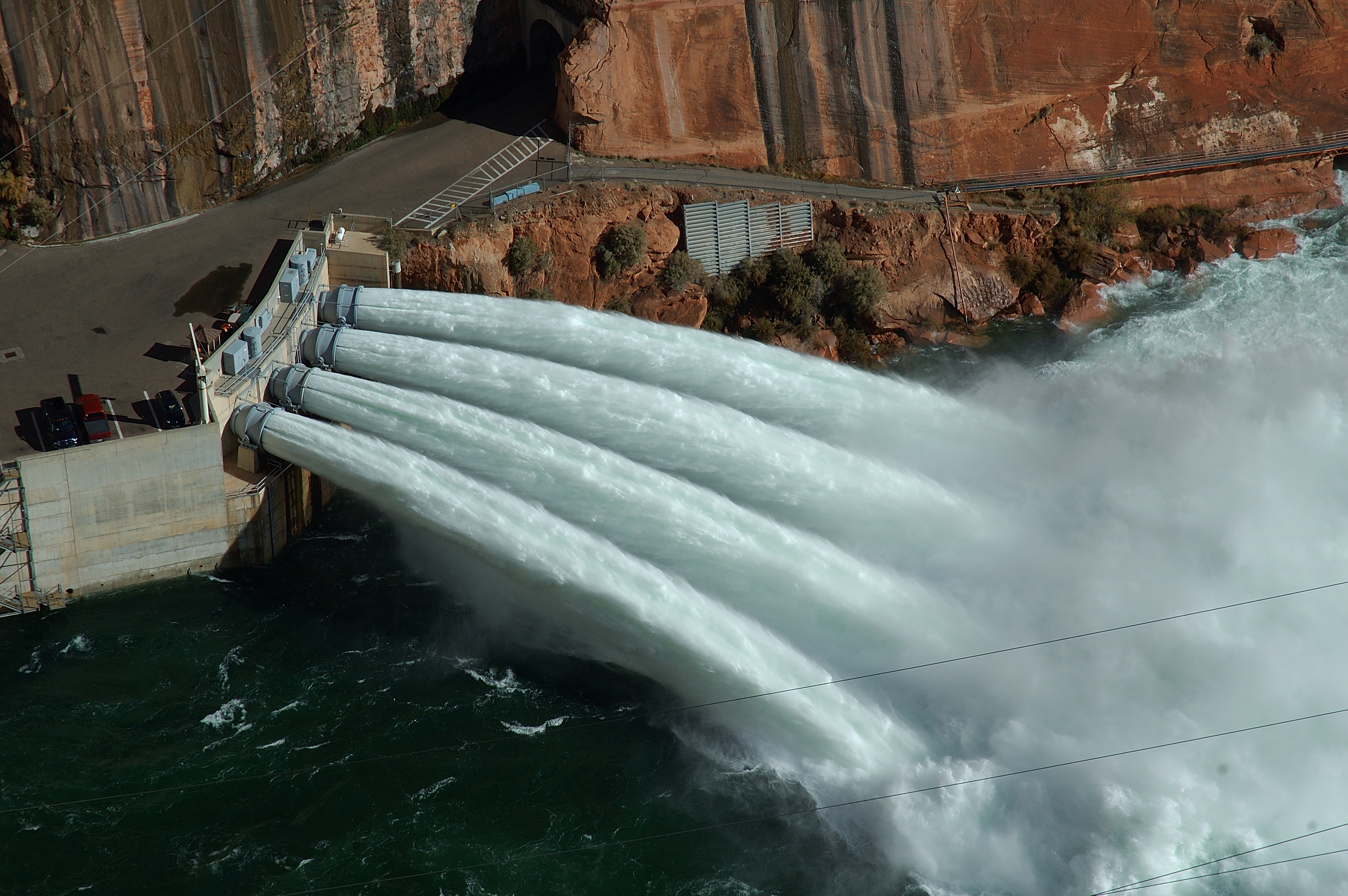
Opening the outlet tubes during a high flow experiment.
Credit: USGS
With sufficient sediment, higher releases would likely build larger sandbars, but such releases would require using emergency spillways, and are outside the scope of the HFE protocol. Whenever river managers implement controlled floods, they also reduce reservoir releases in other months to keep the annual volume of water released from Lake Powell consistent with the agreements established among the users of Colorado River water. Controlled floods can be released following either summer/fall or winter sand-supplying floods in tributaries.
The Colorado River’s Uncertain Future
The success of these initial controlled floods does not guarantee that sandbars will continue to grow. Sandbars erode between each controlled flood. The long-term effects of the HFE protocol depend on how Colorado River runoff, operational decisions about releases from Lake Powell and seasonal precipitation in the Paria River and other tributary watersheds affect the ability of dam operators to continue implementing controlled floods.
A succession of high-snowpack years or operational decisions to transfer water storage from Lake Powell to Lake Mead could result in large releases of clear water that typically cause sandbar erosion. Such releases occurred from 1996 to 2000 and in 2011. In these conditions, sufficient sand accumulation to trigger controlled floods is unlikely. However, almost all climate change projections predict increases in temperature and decreases in Colorado River runoff. With recent annual releases equal to or lower than releases from 2000 to 2010, the HFE protocol is likely to increase sandbar size and allow more sand to be retained in Marble Canyon.
In this uncertain future, balancing ecosystem goals with growing needs for water and power will continue to be a challenge for society. The HFE protocol is one approach to meet some of those demands. While the long-term success of the HFE protocol is dependent on a number of factors, the early results of HFE’s attempts to maintain Grand Canyon’s sandbars show promise for restoring this important part of the Colorado River Basin.
— Paul Grams is a research hydrologist at USGS and Jennifer LaVista is a public affairs specialist at USGS. This post originally appeared as a science feature on the USGS website.