
12 December 2013
NASA’s new LVIS sensor to map polar regions with ‘return to sender’ technology
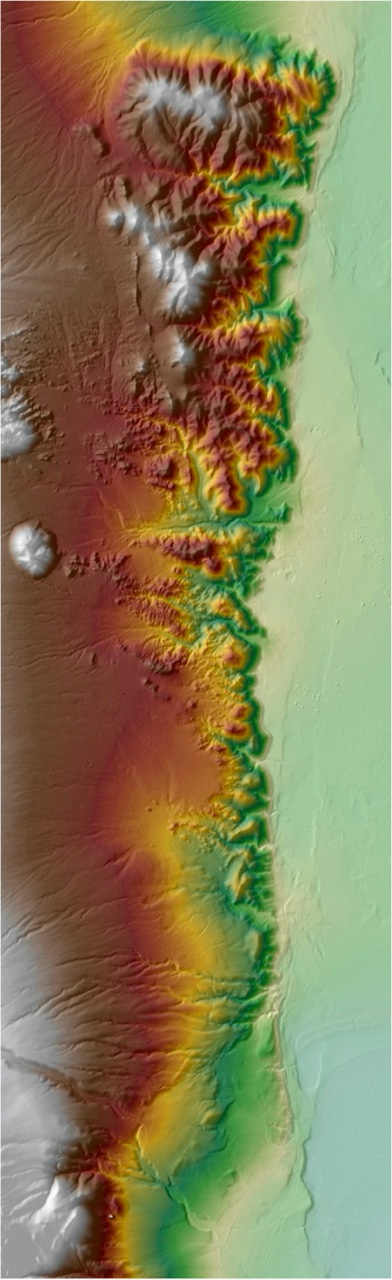
LVIS-GH map of the Sierra Nevada and Death Valley. Credit: LVIS Team at NASA/GSFC.
NASA’s Land Vegetation and Ice Sensor has yet to leave the atmosphere, but that’s the long-term plan for this high-flying mapping technology. In the nearer future, LVIS will produce high-resolution, three-dimensional maps of Earth’s unexplored polar regions, allowing scientists to follow changes in ice cover more accurately than ever before.
Since 1998, LVIS has mapped rainforest canopies in Costa Rica, surveyed Gulf Coast ocean topography, and even tracked ivory-billed woodpeckers in Arkansas. But the LVIS team didn’t take their remote sensing tool to Antarctica until 2009. Flying at 35,000 feet over the Antarctic Peninsula on a DC-8 aircraft, LVIS mapped 7,000 square kilometers—about the size of Delaware—in 11 hours.
LVIS principal investigator Bryan Blair of NASA’s Goddard Space Flight Center presented still more elaborate plans for the sensor in a poster Tuesday at the American Geophysical Union’s Fall Meeting. His team has upgraded LVIS to map a wider swath of surface with greater precision than its forerunner.
LVIS employs lidar technology, a combination of light and radar. The sensor sends a laser down to the surface, and then analyzes the reflection of the laser’s light to gauge the properties of the land below. The new LVIS can measure the thickness of ice to within a few centimeters, and can accurately place features horizontally within two meters, thanks to a greatly improved capability to record the origin point of its own laser.
Called LVIS-GH, the new sensor reaches its maximum potential by flying at more than 60,000 feet on the Global Hawk, a large, unmanned aerial drone used for military surveillance.
The Global Hawk has been around as long as LVIS, but the two weren’t introduced until June 2013, when Blair and his team put LVIS-GH to the test. They operated the Hawk and its equipment from the control room at Dryden Flight Research Center inside Edwards Air Force Base in Southern California. LVIS-GH produced strikingly detailed images of the sloping, jagged Sierra Nevada and the smooth expanse of neighboring Death Valley.
Compared to a typical manned NASA aircraft, the Global Hawk can fly higher, faster, and longer, at about one-tenth the cost per square kilometer. In a single flight on the Global Hawk, LVIS can map up to 50,000 square kilometers—the size of Vermont and New Hampshire—in 31 hours. That’s long enough to take off from Australia or New Zealand and reach the far side of Antarctica.
Soon LVIS-GH will map vast uncharted areas of both poles through Operation IceBridge, a project to fill the data gap between NASA’s original Ice, Cloud and Land Elevation Satellite, or ICESat, retired in 2009, and ICESat-2, which won’t go into orbit until 2016.
But it’s the extraterrestrial potential of LVIS-GH that’s got Blair all shook up. He hopes someday to deploy LVIS-GH to map the surface of Mars. Getting the equipment into space is a big challenge, but after that, he said, “Mars is a little easier in some ways.” At least from a sensor’s standpoint: In Earth’s atmosphere, clouds often get in the way.
– Molly Sharlach is a science communication graduate student at UC Santa Cruz