21 May 2012
Monitoring earthquakes with GPS could yield faster disaster response
Posted by kramsayer

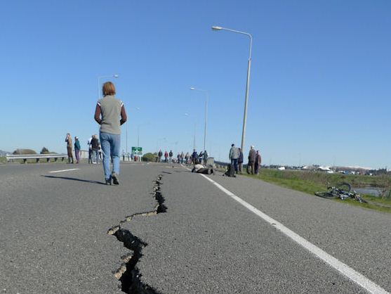
GPS could be used to quickly analyze earthquakes such as this one that damaged a road in Cantebury, New Zealand in 2010. Quicker analysis could also lead to more lives saved in the aftermath of earthquakes. (Credit: martinluff, Flickr)
When the March 2011 earthquake shook Japan, scientists needed about 20 minutes to conduct a full analysis. But now, researchers have found a way to shrink that critical analysis time for large earthquakes to two minutes.
The speedup results from using data from GPS networks for the initial evaluation, rather than readings of seismometers – the traditional earthquake-measurement tools. Scientists can estimate the magnitude and slip (how much and which way fault lines have shifted) of a quake more quickly from GPS readings than from the more complex vibration patterns recorded by seismometers.
The new GPS-based method — tested so far on recorded data from past quakes but not yet on an earthquake in progress — could lead to earlier warnings of impending danger and a quicker emergency response, potentially sparing many lives, said Brendan Crowell, a geophysicist at the Institute of Geophysics and Planetary Physics at the University of California, San Diego, and part of the team that developed the new method.
For large earthquakes, Crowell said rapid evaluation by GPS would allow emergency personnel to respond sooner to damaged areas. Also, scientists could use GPS to determine where the crust moves the most, and where the damage is likely greatest, he added.
The research was published May 5 in Geophysical Research Letters, a journal of the American Geophysical Union.
While seismometers detect vibrations emanating from an earthquake, GPS networks measure how much the earthquake fault physically moves. Both methods require multiple instruments, but Crowell said the GPS data is easier to analyze due to the nature of the measurements. It takes longer to manipulate and analyze the data from seismometers, he said.
“GPS data is a direct measurement of motion, and no further manipulation is necessary,” explained Crowell.
Speeding up the evaluation of an earthquake’s magnitude and slip could prove particularly beneficial in regions prone to tsunamis, Crowell said. That’s because both of these measurements indicate how dangerous the resultant tsunami might be.
Knowing earlier how big a quake is, and where and how much the fault displaced, could allow scientists to sooner create a wave propagation model of the impending tsunami, leading to a more efficient evacuation of the affected coastline, the California-based researchers reported.
Still, Eddie Bernard, a tsunami expert and director of the Pacific Marine Environmental Laboratory (PMEL) in Seattle, questioned how much of a difference a quicker analysis would make with regard to tsunami casualties.
In last year’s Japanese tsunami disaster, detection time was not the main cause of so much damage and loss of life, he said. Instead, many problems stemmed from a tsunami preparedness plan that underestimated the tsunami’s potential size.
Crowell and his colleagues are still working to improve their GPS-based earthquake detection method. Currently, Crowell said, the technique only works for large earthquakes with a magnitude of 5 or greater. Combining the measurements from GPS and seismic sensors could yield better analyses of quakes, but only a while after the shaking has settled down, he added.
In their study, Crowell and his team used recorded GPS readings from several high-magnitude earthquakes that occurred in the past decade. They plan on doing real-time analysis of earthquakes within the year – depending on when the next big one hits.
![]() Crowell, B., Bock, Y., & Melgar, D. (2012). Real-time inversion of GPS data for finite fault modeling and rapid hazard assessment Geophysical Research Letters, 39 (9) DOI: 10.1029/2012GL051318
Crowell, B., Bock, Y., & Melgar, D. (2012). Real-time inversion of GPS data for finite fault modeling and rapid hazard assessment Geophysical Research Letters, 39 (9) DOI: 10.1029/2012GL051318
-Eric Villard, AGU science writing intern


 GeoSpace is a blog on Earth and space science, managed by AGU’s Public Information staff. The blog features posts by AGU writers and guest contributors on all sorts of relevant science topics, but with a focus on new research and geo and space sciences-related stories that are currently in the news.
We recently published an article on how GPS was being use to try and predict tsunamis better. Hopefully next week we will have an interview online with some of the research team from the University of Hawaii who are experimenting with solutions involving commercial shipping.
You can see our article here:
http://www.gpsbites.com/tsunami-early-warning-detection-gps
Thanks! 🙂