
March 26, 2017
Depot & Mondor Glacier Retreat, Antarctic Peninsula
Posted by Mauri Pelto
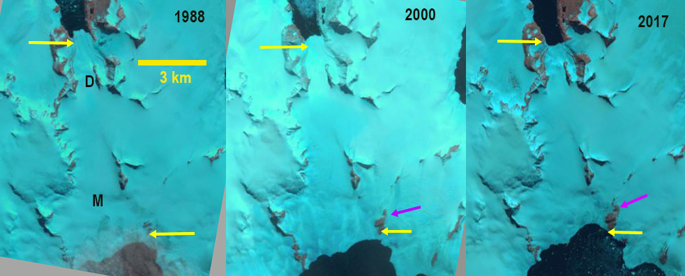
Mondor and (M) and Depot Glacier (D) at the tip of the Antarctic Peninsula in Landsat imagers from 1988, 2000 and 2017. Yellow arrows indicates the 2017 terminus location of each. The purple arrow indicates a bedrock ridge that has been expanding.
On the Trinity Peninsula,which is the region at the tip of the Antarctic Peninsula, are Depot and Mondor that flow north and south from the same accumulation zone emptying into Hope Bay and Duse Bay respectively. The Argentine Research Station, Esparanza is on Hope Bay. This region experienced some of the greatest warming on Earth from 1950-1990’s, but no additional warming since the 1990’s (Turner et al, 2016). This climate change has led to a rapid glaciological response, with 87% of glaciers around the Antarctic Peninsula now receding Davies et al (2012) . The most dramatic response has been the collapse of several ice shelves, Jones, Prince Gustav, Wordie, Larsen A and Larsen B. The Prince Gustav Ice Shelf connecting James Ross Island to the Trinity Peninsula collapsed after 1995 (Glasser et al 2011). There is limited surface melting on Antarctic glaciers, as a result almost all of the mass loss is from bottom melting under ice shelves and calving. These processes have led to and continue to drive dramatic retreat, thinning and acceleration of glaciers that feed ice shelves and the ice shelves, such as Rohss Bay and Coley Glacier Here we examine a glacier that is grounded, which limits the impact of enhanced melting from warmer ocean temperatures. Esparanza Base has a long term climate record with only December and January having a mean temperature above 0 C, at 0.4 and 0.5 C respectively. The record high temperature in Antarctica was recorded at Esparanza Base on March 24, 2015 at 17.5 C (Skansi et al, 2017). Specific anomalously warm days are when most mass balance losses occur. Barrand et al (2013) note a strong positive and significant trend in melt conditions in the region, driving the retreat.
In 1988 Depot Glacier terminus was north of a tributary entering on the west side of Depot Glacier. By 2000 the glacier terminus has receded and is adjacent to the northern side of this tributary. By 2017 the terminus has retreated further and is nearly at the southern edge of the tributary glacier, a retreat of 500 m. Mondor Glacier in 1988 terminates south of bedrock ridge on the east margin of the glacier, yellow arrow. In 2000 the bedrock ridge has expanded and is closer to the terminus. By 2017 the bedrock rib has further extended north, purple arrow, indicating glacier thinning. The overall retreat of the terminus is 400 m from 1988 to 2017. The retreat rate increased after 2000, which is what Davies et al (2012) reported for the region. The rate of retreat is limited as the grounded glaciers have limited calving, and there is limited surface melt. The melt zone is not significant in any of the images on Mondor Glacier. On Depot Glacier there is a melt zone below 200 m evident in both Goggle Earth images, purple arrows and the 2017 Landsat image. The limited changes of this glacier underscores that it is ocean warming that has been the key to date in glacier retreat in the region. There has been a significant temperature rise, but it remains too cold for substantial surface melt.
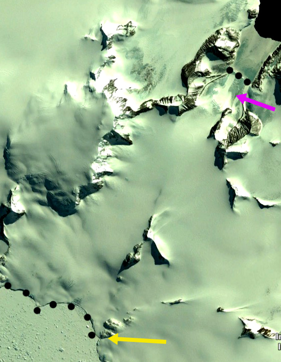
Google Earth image from 2013 of Mondor Glacier terminus, black dots bottom and Depot Glacier black dots top. Purple arrow indicates area of melting where snowpack has been lost. Yellow arrow a bedrock ridge on east side of Mondor Glacier.
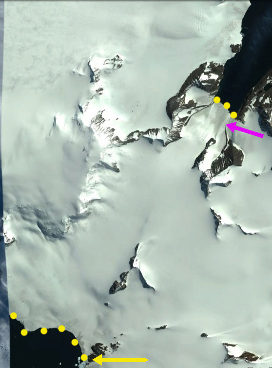
Google Earth image from 2015 of Mondor Glacier terminus, black dots bottom and Depot Glacier black dots top. Purple arrow indicates area of melting where snowpack has been lost. Yellow arrow a bedrock ridge on east side of Mondor Glacier.
 Dean of Academic Affairs at Nichols College and Professor of Environmental Science at Nichols College in Massachusetts since 1989. Glaciologist directing the North Cascade Glacier Climate Project since 1984. This project monitors the mass balance and behavior of more glaciers than any other in North America.