August 1, 2017
34th Annual Field Program NORTH CASCADE GLACIER CLIMATE PROJECT 2017
Posted by Mauri Pelto
2016 Field Season Video
NORTH CASCADE GLACIER CLIMATE PROJECT 2017
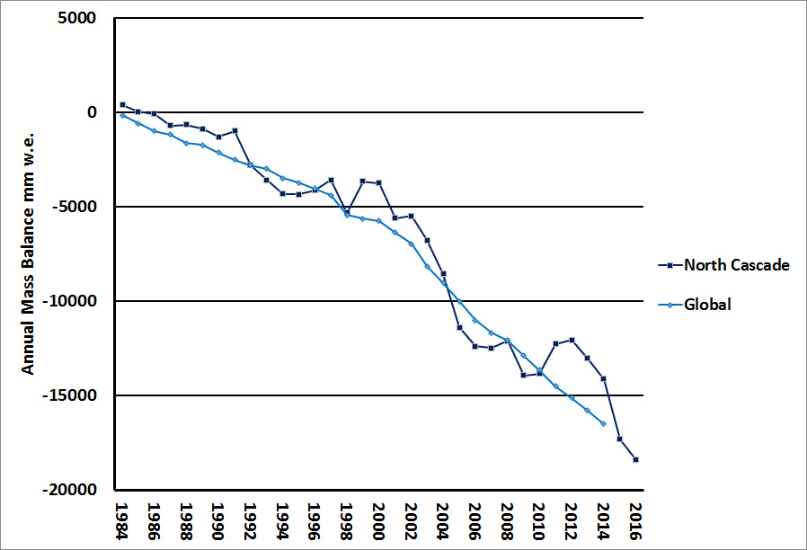
For the thirty fourth consecutive summer it is time to head into the field to monitor the continued response of North Cascade glaciers to climate change. In 1984 when I began this program we selected 10 key glaciers to monitor. Two of these have now disappeared. All the glaciers have retreated extensively and lost considerable volume. The mass balance loss is 19 m of water equivalent thickness, which is over 20 m of ice thickness loss on glaciers that averaged less than 75 m thick. This is significant with 25-30% of their entire volume lost. This project looks at the implications of the glacier loss as we complete an annual inventory of ice worms on Sholes Glacier, mountain goats on Ptarmigan Ridge region and monitor runoff all summer below Sholes Glacier with the Nooksack Indian tribe.
Illustration of research (Megan Pelto and Jill Pelto)
The result of volume loss and area loss is that despite higher melt rates, the reduction in area of melting glaciers has led to a decline in glacier runoff in the region. The reduced runoff effects salmon, hydropower and irrigation. Details of the runoff impacts are detailed in a Book “Climate Driven Retreat of Mount Baker Glaciers and Glacier Runoff and summarized in Salmon Challenges from the Glaciers to the Salish Sea.

The focus will be on mass balance observations, longitudinal profiles and terminus observations. For Mount Baker, Washington the winter freezing level was much lower than the previous two winters, and was 100 m below the long term mean. The snowpack on April 1st snowpack was 110% of normal, by June 10th, the snowpack is trending down steeply, but remained just above average. Since then a persistent dry period and the impending heat wave that begins today, Aug. 1 has led to rapid snow loss. The most recent comparable year is 2009, which featured a good winter snowpack and very warm mid to late summer conditions. We will first travel north to Mount Baker and the Easton Glacier. Of the 40 glacier in the World Glacier Monitoring Service Reference glacier list we have two Columbia and Rainbow, as soon as Easton Glacier has 30 years, the minimum requirement it will be added, that is in 2019. The field team consists of Mauri Pelto, 34th year, Jill Pelto, UMaine for the 9th year, Anthony Himmelberger, Clark University 1st year. Tom Hammond, 14th year will join us for a selected period as will Pete Durr, Mt. Baker Ski Area, 2nd year. We will report on our findings in a month. Field photos will be posted periodically on Twitter.
Measuring terminus change and snowpack thickness in 2016
Aug. 2: Hike into Easton Glacier
Aug. 3: Easton Glacier
Aug. 4: Easton Glacier
Aug. 5: Hike Out Easton Glacier, Hike in Ptarmigan Ridge
Aug. 6: Sholes Glacier
Aug. 7: Rainbow Glacier
Aug. 8: Sholes Glacier
Aug. 9: Hike out and into Lower Curtis Glacier
Aug. 10: Lower Curtis Glacier
Aug. 11: Hike out Lower Curtis Glacier- Hike in Blanca Lake
Aug. 12: Columbia Glacier
Aug. 13: Columbia Glacier
Aug. 14: Hike out Columbia Glacier; Hike in Mount Daniels
Aug. 15: Ice Worm Glacier
Aug. 16: Daniels and Lynch Glacier
Aug. 17: Ice Worm Glacier, Hike out Mount Daniels-Hike out-


 Dean of Academic Affairs at Nichols College and Professor of Environmental Science at Nichols College in Massachusetts since 1989. Glaciologist directing the North Cascade Glacier Climate Project since 1984. This project monitors the mass balance and behavior of more glaciers than any other in North America.