
July 13, 2017
Gabriel Quiroz Glacier, Chile Retreat Forms New Lake
Posted by Mauri Pelto
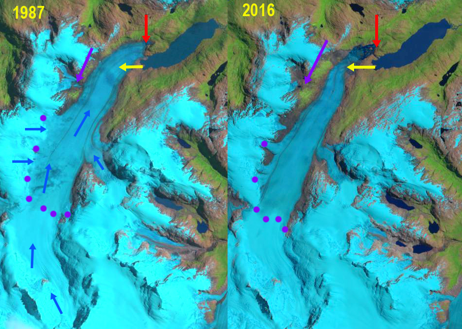
Gabriel Quiroz Glacier, Chile in 1987 and 2016 Landsat images illustrates the retreat. Red arrow is 1987 terminus, yellow arrow the 2016 terminus, purple arrow a retreating northern tributary and purpe dots the snowline.
Gabriel Quiroz Glacier is a northern outlet glacier of the Southern Patagonia Icefield that drains into the Rio Pascua. The glacier in 1987 terminated within 250 m of Lago Gabriel Quiroz. Willis et al (2012) observed that between February 2000 and March 2012 that the Southern Patagonia Icefield is rapidly losing volume and that thinning extends even to high elevations. The overall retreat has been driven by increasing calving rates from the 1975-2000 to the 2000-10 period (Schaefer et al, 2015). The pattern of retreat is consistent between these glaciers and the region as noted by Davies and Glasser (2012), annual rates of shrinkage in the Patagonian Andes increased in from 0.10% year from 1870-1986, 0.14% year from 1986-2001, and 0.22% year from 2001-2011, though they note Gabriel Quiroz Glacier retreat rate from 1870-2011 was low. Glasser et al (2016) observed both an increase in glacier proximal lakes and in debris cover on glaciers with glacier retreat from 1987-2015. In this case the glacier is now terminating in a new and expanding proglacial lake, but has limited debris cover.
In 1987 the glacier terminates 250 m beyond the western shore of Lago Gabriel Quiroz there is no sign of a proglacial lake at the terminus. The snowline is at 950 m in 1987, A tributary from the north almost joins the main glacier, purple arrow. In 2000 a small proglacial lake is evident at the terminus, which has retreated 300 m. The snowline is at 950 m. By 2015 a substantial proglacial lake has formed with an island in it. The lake is 1.6 km long, which represents the retreat of the glacier since 1987. The snowline in 2015 is at 1050 m. In 2016 the proglacial lake is filled with icebergs indicating continue calving driven terminus retreat totaling 2.1 km since 1987. The snowline in 2016 is at 950 m. The terminus remains poised for additional calving retreat, though the calving front has narrowed. The upper limit of the lake basin is not evident. The northern tributary has retreated up valley away from the main glacier. This indicates that even without calving the mass balance of the glacier would be negative and there would be retreat. The retreat is similar to that seen at Balmaceda Glacier, Bernardo Glacier and Glacier Onelli.
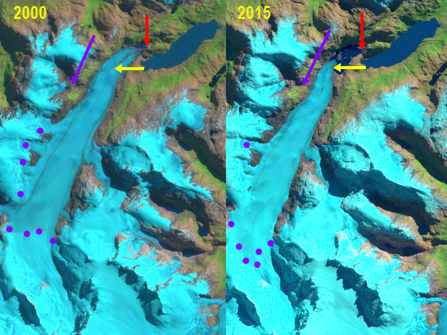
Gabriel Quiroz Glacier, Chile in 2000 and 2015 Landsat images illustrates the retreat. Red arrow is 1987 terminus, yellow arrow the 2016 terminus, purple arrow a retreating northern tributary and purpe dots the snowline.
 Dean of Academic Affairs at Nichols College and Professor of Environmental Science at Nichols College in Massachusetts since 1989. Glaciologist directing the North Cascade Glacier Climate Project since 1984. This project monitors the mass balance and behavior of more glaciers than any other in North America.