
July 6, 2017
Pedersen Glacier, Alaska Rapid Retreat 1994-2015
Posted by Mauri Pelto
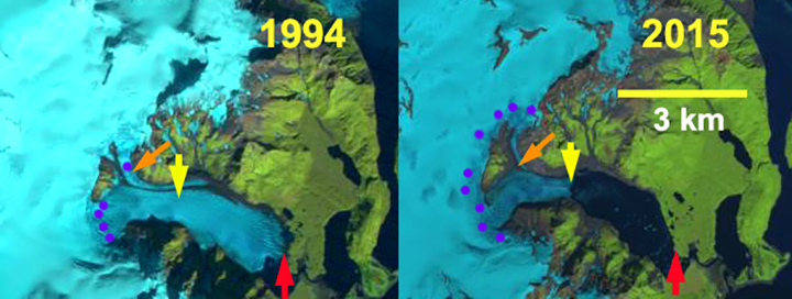
Pedersen Glacier Kenia Peninsula, Alaska retreat from Landsat images in 1994 and 2016. The red arrow indicates 1994 terminus, yellow arrow is 2016 terminus, orange arrow indicates northern tributary and purple dots indicates snowline.
Pedersen Glacier is an outlet glacier of the Harding Icefield in Kenai Fjords National Park near Seward, Alaska. The glacier drops quickly from the plateau of the icefield through a pair of icefalls terminating in a lake at 25 meters above sea level. The Harding Icefield glaciers that drain east are in the Kenai Fjords National Park, which has a monitoring program. Giffen et al (2014) observed that from 1950-2005 all 27 glaciers in the Kenai Icefield region examined retreated. Giffen et al (2014) observed that Pedersen Glacier retreated slow but steady from 1951-1986 at 706 m (20 m/a) and 434 m (23 m/year) from 1986-2005. Here we compare a 1994, 2013, 2015 and 2016 Landsat imagery illustrating a rapid increase in retreat rate from the previous periods.
In 1994 the terminus proglacial lake at the terminus is small and much of the terminus is on land. The snowline in 1994 is at 550 m. The tributary entering from the north, orange arrow, is 400 m wide as it reaches Pedersen Glacier. In 2005 the Google Earth image below indicates extensive terminus crevassing, indicating substantial terminus velocity, and that the retreat is driven by calving. In 2005 the lake is now 1.1 km long on its center axis. By 2015 the glacier has retreated 2600 m since 1994, a rate of 125 m/year, much faster than before. The snowline is average 800 m. The northern tributary is now barely reaching the main glacier and has a width of 150 m. Note there was a medial moraine separating the tributary from the main glacier in 1994 and now this is merely a lateral moraine. This tributary is not particularly impacted by calving losses and indicates a rising snowline is also a source of mass loss for the glacier. A comparison of the 2013, 2015 and 2016 terminus indicates the recession has remained rapid. The glacier is approaching the base of an icefall that would represent the inland limit of the lake and the end of rapid retreat. The snowline in 2013 averages 850 m and is at 800 m on Sept. 30 2016. The glacier follows the pattern of nearby Bear Glacier, Yakutat Glacier, Harris Glacier and the inital phase of retreat on Brady Glacier.

Pedersen Glacier Kenia Peninsula, Alaska retreat from Landsat images in 2013 and 2015. The red arrow indicates 1994 terminus, yellow arrow is 2015 terminus, green arrow indicates 2016 terminus and purple dots indicates snowline.
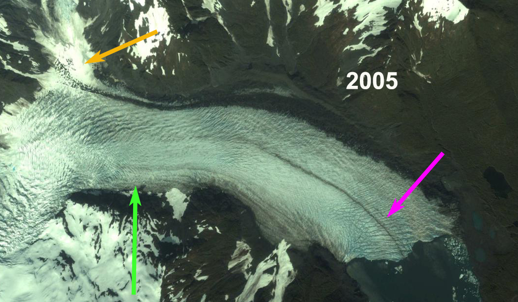
Pedersen Glacier in 2005, note crevassing at the terminus, pink arrow. The northern tributary is indicated by orange arrow and green arrow indicates 2016 terminus position.
 Dean of Academic Affairs at Nichols College and Professor of Environmental Science at Nichols College in Massachusetts since 1989. Glaciologist directing the North Cascade Glacier Climate Project since 1984. This project monitors the mass balance and behavior of more glaciers than any other in North America.
I’m ready to fix global warming, and the rising seas. Are YOU?
[…] glaciers are retreating fastest. This type of glacier includes the popular Bear Glacier and Pedersen Glacier. Bear Glacier retreated by 5 kilometers (3 miles) between 1984 to 2021, and Pedersen Glacier […]
[…] data show that lake-terminating glaciers, which include the popular Bear Glacier and Pedersen Glacier, are retreating fastest. Bear Glacier retreated by 5 kilometers (3 miles) between 1984 to 2021, and […]
[…] data show that lake-terminating glaciers, which include the popular Bear Glacier and Pedersen Glacier, are retreating fastest. Bear Glacier retreated by 5 kilometers (3 miles) between 1984 to 2021, and […]
[…] data show that lake-terminating glaciers, which include the popular Bear Glacier and Pedersen Glacier, are retreating fastest. Bear Glacier retreated by 5 kilometers (3 miles) between 1984 to 2021, and […]
[…] data show that lake-terminating glaciers, which include the popular Bear Glacier and Pedersen Glacier, are retreating fastest. Bear Glacier retreated by 5 kilometers (3 miles) between 1984 to 2021, and […]
[…] KurtzThe data show that lake-terminating glaciers, which include the popular Bear Glacier and Pedersen Glacier, are retreating fastest. Bear Glacier retreated by 5 kilometers (3 miles) between 1984 to 2021, and […]