
June 19, 2017
Potanin Glacier Area, Mongolia Retreat & Fragmentation
Posted by Mauri Pelto

Potanin Glacier, Mongolia comparsion in 1991 and 2016 Landsat images. Yellow dots indicate 2016 terminus, purple dots the snowline, red arrow the southeast margin of proglacial lake, and purple arrows peripheral alpine glaciers that are fragmenting.
Potanin Glacier is in the Altay Mountains of the Tavan Bogd region in western Mongolia, and is the nations longest glacier. The glacier ranges from 2800 to 4000 m a.s.l. and is length is about 11 km long. Konya et al (2008) note the ELA was roughly estimated as 3600 m. The conclude that given the area altitude distribution this indicates the mass balance of Potanin Glacier is negative and it is probable that the glacier is experiencing a negative trend. Konya et al (2010) observed that ablation calculated by an equation using the measured radiation showed good correlation with observed daily ablation, whereas a degree-day model had good correlation with cumulative observed ablation. This region has experienced a substantial warming of 1.6 C in the last sixty year, which has led to a 4.2% decrease in glacier area from 1989 to 2009 in the Tovan Bogd region (Krumwiede et al, 2014). A 2016 expedition to the area led by Aaron Putnam, UMaine Climate Change Institute provides an excellent view of the region (Climate Change, Northwestern, 2016). There expedition was focused on assessing the timing of ice loss at the end of the last ice age. This warming abruptly ended the last ice age and Putnam’s team was looking for the switches that initiate such climate events.
Here we examine Landsat imagery from 1991 to 2016 to identify changes in Potanin Glacier and neighboring glaciers. In 1991 Potanin Glacier terminates near a 500 m diameter proglacial lake, red arrow. The snowline is at 3600 m, purple dots. Three peripheral alpine glaciers at purple arrows 1-3 are each single contiguous glaciers. In 1996 the proglacial lake remains, the snowline is at 3500 m and the peripheral alpine glaciers remain contiguous. By 2014 the proglacial lake is 30% of its former size, with the southeastern margin of the lake remains the same. The snowline is at 3500 m in 2014. In 2016 the three neighboring alpine glaciers have fragmented into multiple sections. Each section remaining has also lost significant area. This is indicative of negative mass balance in the region during the period. The smaller glaciers are more responsive to climate and subsequent mass balance change. The yellow dots on the 1991 and 2016 image represent the 2016 margin. The margin has experience modest retreat averaging 250 m from 1992-2016. At Point 1 the glacier has fragmented into three sections since 1991 with the southern most nearly gone. At Point 2 the glacier has separated into two parts with the eastern one largely gone. The continued fragmentation of smaller glaciers will lead to their disappearance in the coming decades. The large supraglacial streams that are present indicate the limited velocity and high melt rates in the terminus region, see below. The mass balance of the World Glacier Monitoring Service Maliy Aktru, in the Russian Altay has been negative in all but five years since 1990.
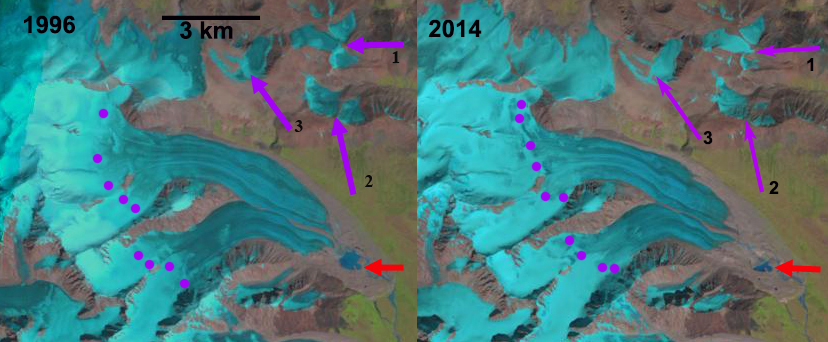
Potanin Glacier, Mongolia comparsion in 1996 and 2014 Landsat images. Purple dots the snowline, red arrow the southeast margin of proglacial lake, and purple arrows peripheral alpine glaciers that are fragmenting.
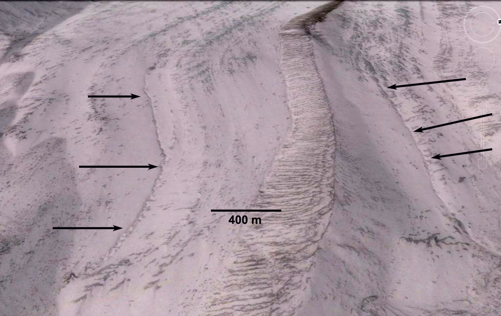
Streams channels on surface of Potanin Glacier in Google Earth image. The extent and size indicates limited velocity and high ablation.
 Dean of Academic Affairs at Nichols College and Professor of Environmental Science at Nichols College in Massachusetts since 1989. Glaciologist directing the North Cascade Glacier Climate Project since 1984. This project monitors the mass balance and behavior of more glaciers than any other in North America.
Hey good job guys! I’m from Mongolia. Also I have been doing research on Potanin Glacier with Aaron Putnam and his research team with my classmate as an undergraduate student of Geology since 2016. Could you share about this research on Landsat imagery? Who made this one?
I did the analysis, as is the case with all satellite imagery in these posts.