May 15, 2017
Azaubashi Glacier Fragmenting, Mount Elbrus, Russia
Posted by Mauri Pelto
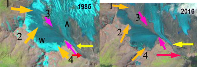
Azaubashi Glacier (W) and Azau Glacier (A) in 1985 Landsat and 2016 Sentinel Image. Orange arrows indicate particular areas of fragmentation and bedrock expansion. Pink arrows indicate connection with Azau Glacier the terminus of which in 1985 is at red arrow and in 2016 is at yellow arrow.
Azaubashi Glacier is on the southwest side of Mount Elbrus, Caucasus Mountains of Russia, merging with the Greater Azau Glacier. The glacier drains east from Gora Azaubashi (3600 m). The glacier is west of the ski complex at Prielbrusye, that has lifts from Azau at 2300 m to Krugozor at 3000 m and Mir at 3500 m. Shahgedanova et al (2014) report glaciers on the mountain experienced a 5% loss in area from 1999-2012, with the Azaubashi Glacier losing a much higher percentage.
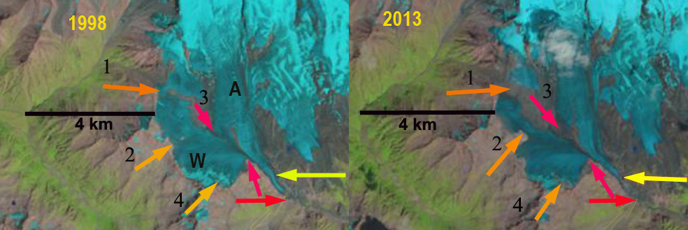
Azaubashi Glacier (W) and Azau Glacier (A) in 1998 and 2013 Landsat Images. Orange arrows indicate particular areas of fragmentation and bedrock expansion. Pink arrows indicate connection with Azau Glacier the terminus of which in 1985 is at red arrow and in 2016 is at yellow arrow.
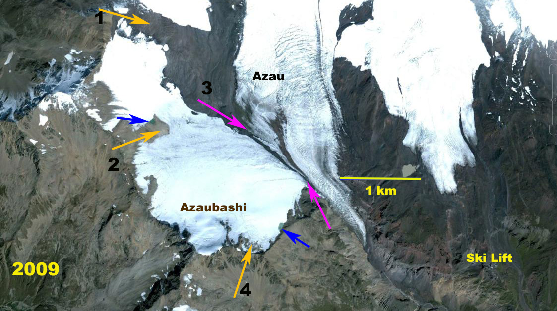
Here we examine Landsat images from 1985 to 2016 to quantify the substantial change. In 1985 the glacier extends north from Azaubashi to join with glaciers on the upper slopes of Elbrus in a 4 km continuous sweep. At Arrow 1 and 2 the glacier is continuous and extends at least 800 m from top to bottom. At Arrow 3 the glacier connection with Azau Glacier is extensive. At Arrow 4 the glacier extends to the ridge. By 1998 At Arrow 1 a bedrock arrow has nearly separated the glacier. At Arrow 2 the glacier remains at least 700 m from top to bottom. The connection between Azaubashi and Azau Glacier remains extensive. At Arrow 4 the glacier extends to the ridge. By 2013, the bedrock exposed at Arrow 1 is 300 m wide. At Arrow 2 the glacier is nearly severed with a connection of just 300 m. At Arrow 3 the connection between glaciers is now discontinuous and tenuous. At Arrow 4 the glacier no longer extends to the ridgeline, The snowline on the south side of Mount Elbrus is at 3700 m. In 2016 the main change is the continued disconnection between Azaubashi Glacier and Azau Glacier, the connection that in 1985 was 1500 m long is now just 500 m long. The glacier will soon be split into three sections. The glacier did not retain any snowcover in 2016, in 1998 and 2013 less than 10% of the glacier retained snowcover. The snowline in 2016 was at 3700 m on Aug. 28th. This indicates a glacier that cannot survive current climate as it lacks a consistent significant accumulation zone. The retreat from 1985 to 2016 of the Azau Glacier noted at the red and yellow arrows has been 650 m. The Azau Glacier still has an extensive accumulation zone. TheAzaubashi Glacier is similar to the Dzhikiugankez Glacier in losing mass across nearly its entire surface.
Azaubashi Glacier in 2009 Google Earth image. Orange arrows indicate particular areas of fragmentation and bedrock expansion. Pink arrows indicate connection with Azau Glacier, blue arrows indicate two small lakes developing in previously glacier covered areas.


 Dean of Academic Affairs at Nichols College and Professor of Environmental Science at Nichols College in Massachusetts since 1989. Glaciologist directing the North Cascade Glacier Climate Project since 1984. This project monitors the mass balance and behavior of more glaciers than any other in North America.