
April 26, 2017
Fasset Glacier, Alaska Retreats from Tanis Lake
Posted by Mauri Pelto
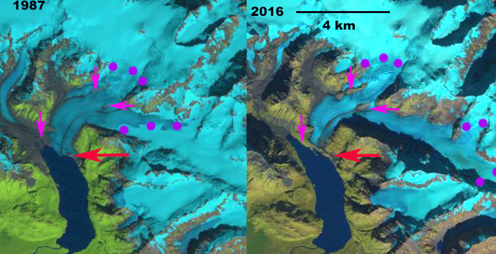
Fasset Glacier in 1987 and 2016 Landsat images. Red arrow indicates glacier front in 1987, pink arrows indicates areas where glacier retreat has exposed rock/bare ground and purple dots indicate snowline.
Fasset Glacier drains west from The Brabazon Range near Yakutat and had terminated in Tanis Lake for the entire 20th century. (Truessel et al 2013) and Truessel et al (2015) note the rapid retreat and thinning of nearby Yakutat Glacier. Here we examine Landsat imagery that illustrates the retreat from 1987 to 2016.
The glacier extended most the way to the southern end of the Tanis Lake in the 1951 Yakutat map. In 1987 the glacier terminated on the northeast shore of Tanis Lake. The calving front in the lake was 800 m wide. The snowline was at 600 m. In mid-June of 2014 the snowline was already at 600 m, by the end of the melt season it was at 900 m. In 2016 the terminus of the glacier no longer reaches Tanis Lake. The eastern side of the terminus is stagnant and ends 200 m from the shore of the lake. The western edge terminates in a new lake that is forming. The average retreat has been 250 m for the glacier from 1987-2016. The larger changes are upglacier of the terminus where large areas of bedrock have been exposed due to retreat, and several segments of the glacier that used to be joined have separated. The snowline is at 850 m in 2016. There are three large areas of bedrock denoted in the 2014 Google Earth image below. The two at 500 m well above the terminus appeared as medial moraines in 1987 and are now bedrock ridges 600 m and 1100 m long. There is a group of ogives extending below these two locations indicating the annual flow rate is 100 m/year in this reach of the glacier. The new lake is also evident in the Google Earth image.
Walker Glacier, Yakutat Glacier and East Novatak Glacier are nearby glaciers that have experienced greater recent retreat than Fasset Glacier. Fasset Glacier is poised to continue a moderate rate of retreat.

USGS Yakutat map from 1951
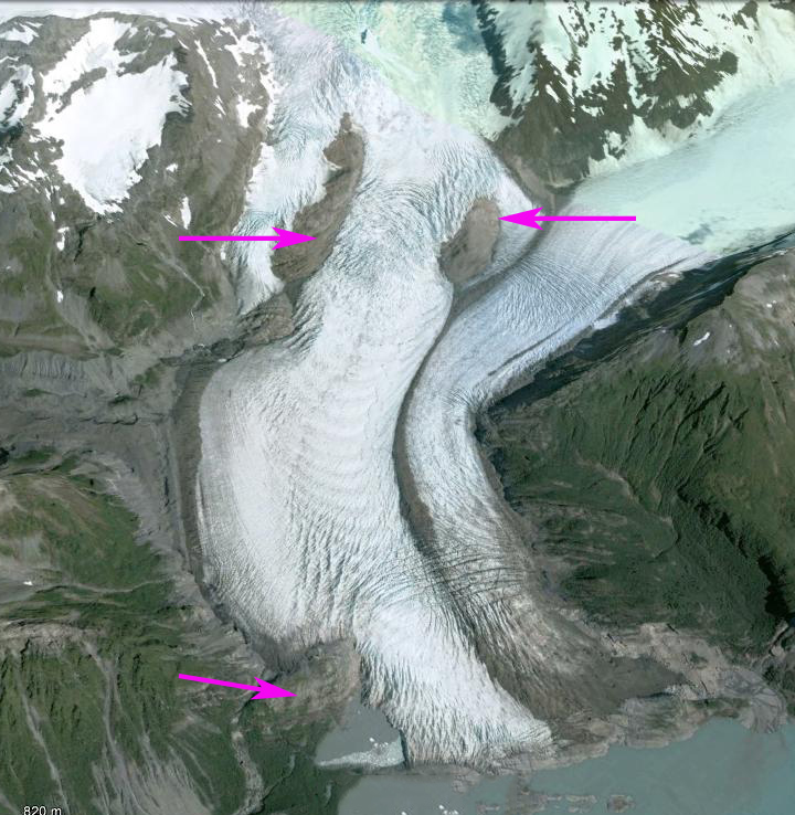
2014 Google Earth image, pink arrows indicate three areas of thinning.
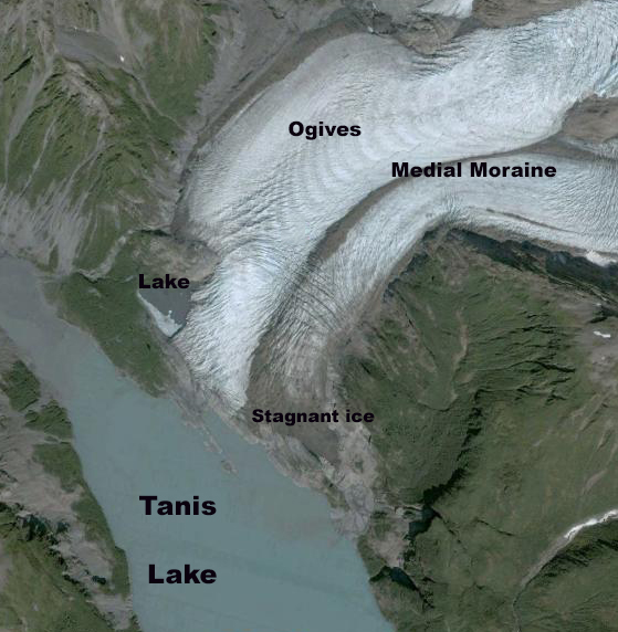
2014 Google Earth image.

2014 June Landsat image indicating snowline.
 Dean of Academic Affairs at Nichols College and Professor of Environmental Science at Nichols College in Massachusetts since 1989. Glaciologist directing the North Cascade Glacier Climate Project since 1984. This project monitors the mass balance and behavior of more glaciers than any other in North America.