
March 29, 2017
Vallunaraju Glacier Retreat, Peru 1992-2016
Posted by Mauri Pelto
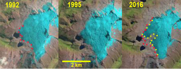
Vallunaraju Glacier comparison in Landsat images from 1992, 1995 and 2016. Red dots represent the 1992 margin and yellow dots the 2016 margin
The Cordillera Blanca, Peru has 27 peaks over 6,000m, over 600 glaciers and is the highest tropical mountain range in the world. Glaciers are a key water resource from May-September in the region (Carey, 2010). Mark Carey describes the importance of glacier runoff to the Andean society in this region in his book”In the Shadow of Melting Glaciers: Climate Change and Andean Society“. The loss of snow and consequent impacts is also beautifull illustrated by Ben Orlove and others in the book “Darkening Peaks : Glacier Retreat Sciecne and Society”. The glaciers in this range have been retreating extensively from 1970-2003, GLIMS identified a 22% reduction in glacier volume in the Cordillera Blanca. Vuille (2008) noted that the mean retreat rate has increased from 7-9 meters per year in the 1970’s to 20 meters per year since 1990. One of the glaciers that is receding is Vallunaraju Glacier descending the west slopes of Vallunaraju. This glacier drains into the Rio Santa in Huarez, Peru. Baraer et al (2012) notes the importance of glaciers to the Cordillera Blanca watersheds in the Huarez region, which receive at least 30% of their runoff from glaciers. Rio Santa is undergoing a decline in dry-season flow that likely began in the 1970s and given the weak correlation between discharge and precipitation suggests the trend is driven by the glacier retreat. Bury et al (2013) examined glacier recession in the Cordillera Blanca, declining Santa River discharge, and alpine wetland contraction noting that water shortages already exist in the basin. Fraser (2012) reporting on recent NSF research project examining water from interdisciplinary perspectives throughout Peru’s Santa River watershed—from Cordillera Blanca glaciers to the Pacific Ocean. That included Mark Carey, University of Oregon, Bryan Mark at Ohio State University, Jeffrey Bury at UC Santa Cruz, Kenneth Young at the University Texas, Austin, and Jeff McKenzie at McGill University.
In 1992 Vallunaraju Glacier extended to the cliffs immediately above the northern of two alpine lake adjacent to the glacier and within 400 m of the southern alpine lake, red dots in Landsat above. By 2003 the glacier seen in Google Earth imagery had retreated from cliff top above the northern lake. By 2011 the glacier had retreated 100-200 meters across the entire glacier front since 2003. An area of bedrock between two terminus lobes had also begun to expand rapidly. This expansion continued up to 2016. The retreat of the glacier from 2003-2016 averaged 180 m across the glacier front. Retreat from 1992-2016 ranged from 200-300 m. The glacier remains heavily crevassed indicating significant glacier flow resulting from substantial annual accumulation. In every Landsat image analyzed there is a significant snowcovered area. The glacier though receding maintains a significant accumulation zone and can survive current climate. The glacier is adjacent to the retreating Llaca Glacier.
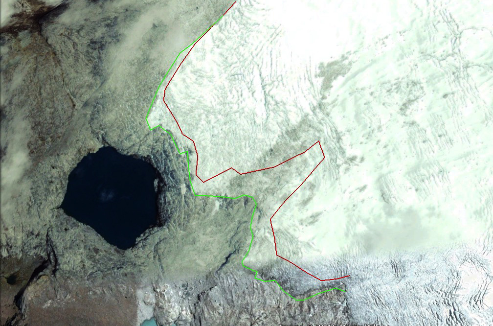
2003 Google Earth image of Vallunaraju Glacier. Green line is the 2003 margin and red line the 2013 margin.
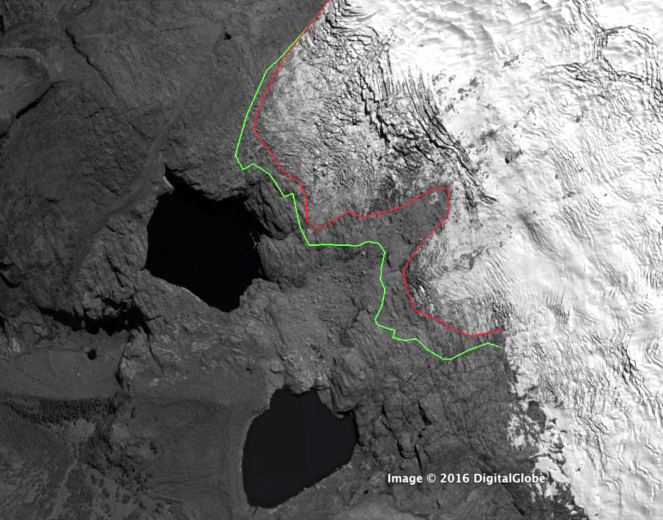
2011 Google Earth image of Vallunaraju Glacier. Green line is the 2003 margin and red line the 2013 margin.
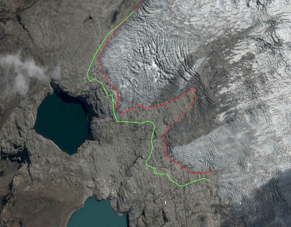
2013 Google Earth image of Vallunaraju Glacier. Green line is the 2003 margin and red line the 2013 margin.
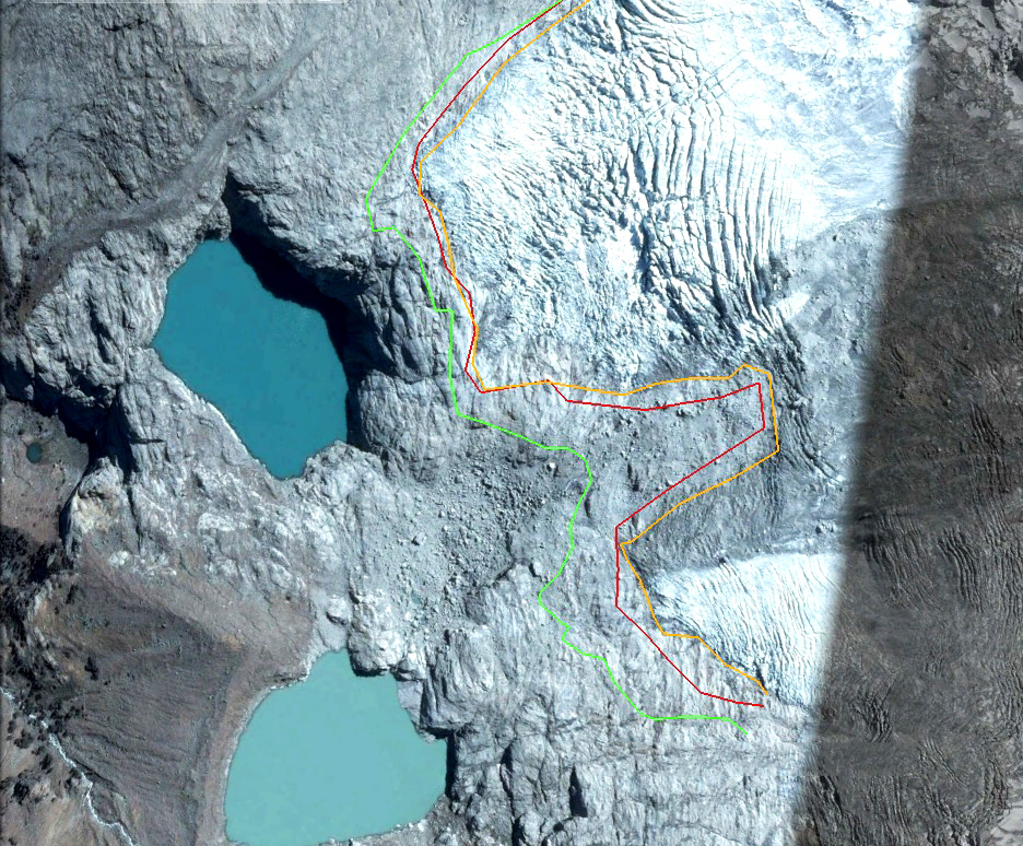
2016 Google Earth image of Vallunaraju Glacier. Green line is the 2003 margin and red line the 2013 margin. and orange line is the 2016 margin
 Dean of Academic Affairs at Nichols College and Professor of Environmental Science at Nichols College in Massachusetts since 1989. Glaciologist directing the North Cascade Glacier Climate Project since 1984. This project monitors the mass balance and behavior of more glaciers than any other in North America.
Vallunaraju consistently has one of the highest light absorbing particle loads as measured by the American Climber Science Program. http://www.the-cryosphere.net/9/331/2015/