January 20, 2017
Penny Ice Cap Northern Outlet Retreat, Baffin Island
Posted by Mauri Pelto
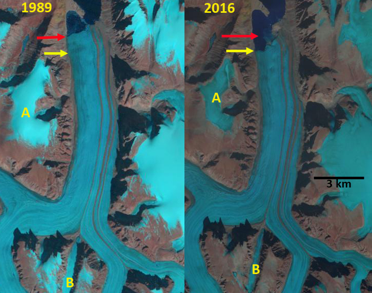
Penny Ice Cap Northern Outlet Glacier #43 in 1989 and 2016 Landsat images. Red arrow indicates 1989 terminus, yellow arrow 2016 terminus. Two peripheral ice masses are at Point A and B.
The primary northern outlet from the Penny ice Cap is an unnamed glacier, noted as #43 in the recent study by Van Wychen et al (2015). it is one of two large tidewater outlet glaciers on Baffin Island. Here we examine the response driven by climate change of this glacier from 1989 to 2016 using Landsat and Sentinel Imagery. Van Wychen et al (2015) observe that it is one of the two largest discharging glacier on the island and the Penny Ice Cap, with Coronation Glacier. They observed peak velocities of over 100 m/year, 20 km upglacier of the terminus, declining to less than 20 m/year in the lower 10 km of the glacier. Zdanowizc et al (2012) noted that in recent years the ice cap has experienced heightened melt, a longer melt season and that little retained snowpack survives the summer, that most of the retained accumulation is refrozen meltwater or superimposed ice. Geodetic methods indicate surface lowering of up to 1 m/year on all ice masses on Baffin Island and Bylot Island between 1963 and 2006 (Gardner et al.2012).
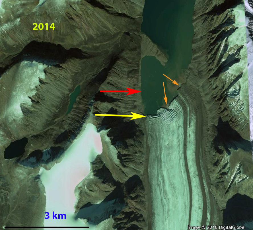
In 1989 the glacier terminated 1 km south of a terminal moraine peninsula that extends most of the way across the fjord. By 2014 glacier retreat is accompanied by the formation of two deltaics areas in front of the glacier, orange arrows in images below. It is not clear if these are islands, a shoal in the fjord or the head of the fjord. Retreat from 1989 to 2016 is 900 m on the west side of the terminus, 600 m on the east side. Two peripheral ice masses at Point A and B lack snowcover in 2016 and have lost area as well. Extensive transverse crevasses develop in the last 700 m upglacier of the terminus, indicating the force imbalance that enables and enhances calving at the ice front, yellow arrow. The reduced retained snowpack on the Penny Ice Cap is leading to reduced discharge and glacier retreat. With a high snowline in 2016 indicated by the lack of retained snowpack on ice masses at Point A and B, it is clear this trend is ongoing. The impact is less dramatic than those noted in the Clephane Bay area of Baffin Island.
Penny Ice Cap Northern Outlet Glacier in 2016 Sentinel 2 image. Yellow arrow indicates crevassing triggered by calving processes, orange arrows developing deltaics areas.
A 2014 Google Earth image of glacier front. Red arrow indicates 1989 terminus, yellow arrow 2016 terminus and orange arrows deltaic land areas building.


 Dean of Academic Affairs at Nichols College and Professor of Environmental Science at Nichols College in Massachusetts since 1989. Glaciologist directing the North Cascade Glacier Climate Project since 1984. This project monitors the mass balance and behavior of more glaciers than any other in North America.