May 20, 2016
Clephane Bay Ice Cap, Baffin Island Being Erased from Map
Posted by Mauri Pelto
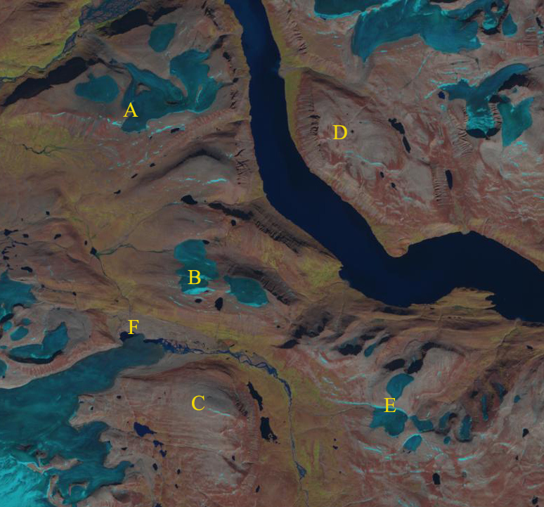
Comparison of 1995 and 2014 Landsat images of ice caps A, B, C, D and E. Pink arrows indicate where A, B and E separated. C and D have disappeared. F is an outlet glacier with a retreating terminus.
The southern part of the Cumberland Peninsula on Baffin Island features many small ice caps. Here we examine the disappearance of two and the separation of two others from 1995 to 2014. Way (2015) noted that on the next peninsula to the west, Terra Nivea and Grinnell Ice Cap had lost 20% of their area in the last three decades. The retreat and disappearance of ice caps in the area have led to a INSTAAR project at UColorado-Boulder examining vegetation that had been buried and is now being exposed. Gardner et al 2011 and Sharp et al (2011) both note that the first decade of the 21st century had the warmest temperatures of the last 50 years, the period of record. They identified that the mass loss had doubled in the last decade versus the previous four for Baffin Island. This is causing ice caps like Dexterity and those around Clephane Bay to melt away
In 1995 ice caps A-E are each a single coherent ice cap, there are narrow points of connection between sections on A, B and E. Ice Caps C and D are simple ice caps between 500 and 800 m across on their widest axis. The terminus of the outlet glacier at F is an expanded lobe. Only Ice Cap A has a significant area above 800 m. The rate of loss from 1995 to 2002 is not as rapid as after, C and D still exist, A,B and E are still connected as a contiguous ice mass. In 2013 ice cap C and D are gone. The snowline is generally above A, B and E with only a small stripe of retained snow on each. Ice cap A, B and E have each separated into multiple parts. In 2014 there is no retained snow on the ice caps, pink arrows indicate the location of separation for ice caps A,B and E. In 2014 the terminus lobe at Point F has lost half of its area, retreat in distance will not accelerate. The lack of retained accumulation most years indicates no accumulation zone and the ice caps cannot survive without that. The only clear image in 2015 indicates a snowcover in August, but this appears to be from a summer snow event.
Canada Toporama map of the region.
2002 Landsat image limited retained snowpack
2013 Landsat image no retained snowpack.
2015 Landsat image, appears that a summer snowstorm has spread snow across ice covered regions above 500 m.


 Dean of Academic Affairs at Nichols College and Professor of Environmental Science at Nichols College in Massachusetts since 1989. Glaciologist directing the North Cascade Glacier Climate Project since 1984. This project monitors the mass balance and behavior of more glaciers than any other in North America.