
April 14, 2016
Goddess of Light (Kolahoi) Glacier Showing Mortality, Kashmir Retreat 1993-2015
Posted by Mauri Pelto

Kolahoi Glacier comparison in Landsat images from 1993 to 2014. Kolahoi Glacier is the northern glacier, East Kolahoi Glacier the other noted glacier. Red arrows indicate 1993 terminus locations, and yellow arrows the 2014 terminus locations.
The Kolahoi Glacier in Kashmir is known as the—”goddess of light”—Gwash Brani (NatGeo, 2010). The glacier descends the north side of the mountain with two tongues of the glacier merging above the terminus in 1993. The glacier drains into the Liddar River and then the Jhelum River system. The Jhelum River has several large operating hydropower stations and several more under construction including the Karot Hydropower Project a 720 MW run of river project. Jeelani et al (2012) observed that the Liddar Watershed derives 60% of its runoff from snowmelt and just 2% from glacier ice melt. They further report that the Liddar watershed has 17 glaciers covering an area of 40 km2 in 2008. The climatic warming in the region has led to mass wasting of Kolshoi Glacier and retreat. From 1970 to 1990 there was a cooling trend of about −0.02°C per year followed by the time period from 1991 to 2010 with the highest increasing trend of 0.07°C per year (Jeelani et al 2012) . Tayal (2011) observed the detachment of the two glacier branches and a loss of 2-3.5 m of ice thickness due to ablation in the lower reach of the glacier.
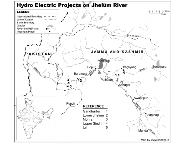
Hydropower Projects in Jhelum Basin.
From 1993 to 2001 there is limited retreat of Kolahoi Glacier and East Kolahoi Glacier, though both glacier fronts become narrower. By 2006 Kolahoi Glacier has retreated to near the base of a steeper slope. The glacier remains heavily crevassed in the region above the icefall within 1 km of the terminus, Point A. By 2014 the glacier has retreated to the top of the steeper slope between two bedrock knobs at 3650 m, total retreat from 1993 to 2014 is 700 m. Crevassing above the slope, at Point A, that used to be an icefall has become limited since 2006 and before. The reduction in velocity indicates retreat will continue. The western tributary of the Kolahoi has developed a separate termini from the main glacier after 2001, single vertical red arrow.. The East Kolahoi Glacier has retreated 300 m. The lower 300 m of Kolahoi Glacier is thin and relatively uncrevassed. This indicates the retreat will continue. This region has its highest precipitation from January through April and highest runoff in June and July. Hence, the glacier is not a summer accumulation type like glaciers to the east in the Himalaya. The retreat is similar to that of Samudra Tupa Glacier and Durung Drung Glacier.
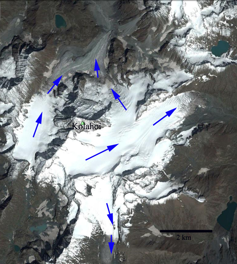
Google Earth image from 2014 of Mount Kolahoi and its main glaciers flow directions indicated.

2001 Landsat image of Kolahoi Glacier
2015 Landsat image of Kolahoi Glacier

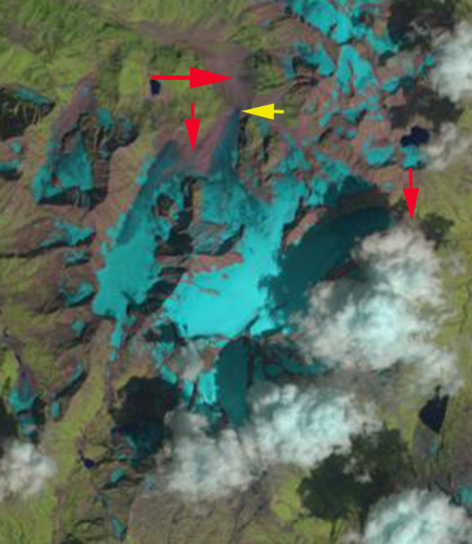
Google Earth image of the terminus area outlined in blue of Kolahoi Glacier in 2006 and 2014.
Image of the terminus of Kolahoi Glacier in 2010 from Jellani et al (2012)
 Dean of Academic Affairs at Nichols College and Professor of Environmental Science at Nichols College in Massachusetts since 1989. Glaciologist directing the North Cascade Glacier Climate Project since 1984. This project monitors the mass balance and behavior of more glaciers than any other in North America.
Thanks for your blog. I hope this OT post is appropriate.
I am no expert but have been engaging (probably foolishly) with a climate “skeptic” online.
I pointed out the World Glacier Monitoring Service and he came back with the following link:
http://www.currentscience.ac.in/Volumes/106/07/1008.pdf
As a non expert my response is that Bahuguna et al is a short term study over a small part of the planet, while WGMS is global in extent. Is this a reasonable response?
The paper claims to monitor 2018 glaciers over a 10 year period. Is this feasible?
If Himalayan glaciers are relatively stable, this is good news for India, though I expect not particularly relevant for the state of glaciers globally.
There are many inventories of Himalayan glaciers that indicate a consistent net area and volume loss using various satellite platforms. The paper you indicate is over a very short period and they found 248 retreating versus 18 advancing, not an even mix. They did not distinguish snout change of most, but the resolution and time period were not ideal, and this does not indicate steady state, since area loss and thinning were still occurring in the region. Look at the Himalayan Index for details on many glaciers and studies.
[…] (Si noti che l’immagine è stata ruotata in modo che il nord sia in alto a sinistra). Il ghiacciaio Kolahoi, uno dei più grandi ghiacciai della regione, si trova sul suo versante settentrionale. Il monte […]
[…] above sea level. (Note that the image has been rotated such that north is toward the top-left.) Kolahoi Glacier—one of the largest glaciers in the region—rests on its northern slope. Mount Harmukh (5,142 […]